Feeling Like a Krispy Kreme?


Snow, snow all around…

Filling in to the west, filling in to the east. Raleigh left in the doughnut hole.

Should begin to snow in the Triangle over the next hour or so and then we’ll see how long the precip lasts…cutting off in Raleigh before midnight.

Hopefully we can achieve that inch or two!

Again, be safe and take it slow as just a little snow on these cold roads will make driving tricky.


Monkey in the Middle?

As we’re about to get the party started, wintry precip is breaking out all over the deep south coastal areas.

The short term modeling is now suggesting that the inland precip shield may dissipate in favor of the precip band on the western edge of the bombing offshore cyclone.  Meaning that the snow moving northward thru GA and SC might begin to dissipate as is moves into the southern Piedmont of NC as moisture and energy is transferred to the developing precip band directly associated with the rapidly deepening storm.  So, there could be a relative minimum between these two, which would leave Wake Co as the monkey in the middle.  This, as opposed to that band coming out of SC holding together a little farther north, while the eastern band forms just a little farther west.

Still too early to make any major pronouncements, as it’s a developing situation…literally.  Greenville to Norfolk still looks to be the sweet spot.  But for Wake Co., probably more like a dusting to an inch, with those higher total scenarios, while not off the table, certainly looking more sketchy.  Remember, though, that the ground is very cold and just a little snow will go a long way in making travel slick very quickly.


The Trend Is Your Friend

…but do we have a trend?

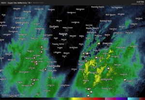
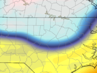
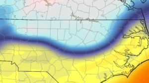
This afternoon’s Euro shifted the storm track significantly westward, and closer to the NAM 3km.  One run doth not make a trend, so we wait to see what the next cycle shows.  NC probably gets most of its moisture rung out as snow from confluence forced by an inverted trough and costal baroclinic zone to the west of the eventual storm track.  It’s a highly dynamic system that will lead to a spectacular storm.  And the questions remain just where all these fireworks take place from the novel winter storm in the FL Panhandle northward to most all areas along the Eastern Seaboard.

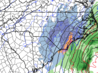
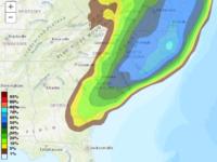
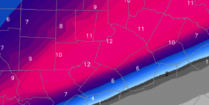
For NC you’ve got two things going on: 1) moisture coming together ahead of the storm that will produce light to moderate snow in the eastern 1/3 of the state, and 2) the storm system really beginning to bomb out as it approaches NC’s latitude on it’s race northward to Newfoundland.  The extent to which rapid cyclogenesis occurs, how close the low is to the coast and what the precipitation shield looks like will all dictate how much bonus snow eastern NC will tally.  If the low tracks a little farther west under more influence of the coastal trough, then NC snow totals will edge higher.  Obviously, the opposite is also a viable option, resulting in just light accumulations.

I hesitate to throw around things like the Jan 2000 storm, but there are some similarities.  Again, it’s a highly dynamic situation and in these situations it’s best to see how the precipitation begins to blossom in the early stages before we write off one solution or another as implausible.

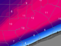
To summarize…this will be a storm where the accumulation gradient lines up mostly WSW  to ENE… i.e. this is not a Roxboro gets all the snow where everybody south gets nothing.  Highest snow totals should be found in northeastern NC.  My best estimate is that Wake county will see 1″ near the airport, ramping up to 2-3″ at the JoCo border.  Higher totals will be eastward in a band from say Greenville to Norfolk where they could be looking at 3-6″, possibly more.  Snow begins tomorrow afternoon.

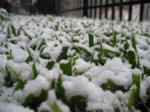
Finally, need I remind you that it’s cold?!  And any snow on the ground will only make it colder.  Also, the breezy conditions behind the storm will make the cold bite even more.  Be prepared.

Update:  most 18Z guidance came in wetter and farther west.  we shall see if this is a trend.  if so, totals my be increased a category.


Eastern NC Snow to Come

Snow appears likely to be flying in eastern NC beginning Wed afternoon thru Thursday.

What first looked to be an out-to-sea storm system only grazing the Outer Banks, now looks destined to swing farther westward, spreading snow into at least the eastern third of NC.  There are major discrepancies between the coarse global models and the higher resolution mesoscale models.  The global models tend to be farther east with the precipitation shield.  The mesoscale models are farther west and insist on explosive cyclogenesis that will make for enhanced precipitation totals as well as gale force, gusty winds.

At this point, there is much uncertainty as to the evolution of the storm.  We will look for more clarity on the upper level phasing through the modeling that comes later tonight and tomorrow morning.  A sharp back edge of snow accumulations seems likely.  So…will Raleigh have some flurries or a dusting…or will Raleigh get several inches?  A range of possibilities are on the table at this point with this highly dynamic system.

Stay tuned.


Snow Problem!

I like my broad brush outline from a couple days ago for Raleigh….

…lots of rain, mixing at times with snow as the day wears on tomorrow.  then, finally changes to all snow.  The question will be, how much moisture is left when the changeover happens.  i.e. how much snow falls at the end?

Additionally, there is thermodynamical cooling to consider with bursts of heavy precipitation as snow melts.  Translation…when it snows in an above freezing boundary layer, if it snows hard, then as all those snowflakes melt, they rapidly cool the local atmosphere.  This cooling lets the subsequent snow survive all the way to the ground.  It can briefly accumulate on the ground and stir folks into a tizzy before the snow melts a little later.

It looks like there will be a fair bit of rain tomorrow morning, then after lunch Raleigh will see periods of rain/snow mix or maybe even a period of snow, but mostly rain until later in the afternoon when snow mixing in becomes favored.  Into the evening, snow becomes more likely to the end on Saturday AM.  In Raleigh, I think there will be a minor dusting accumulation (an inch would be lucky) on the grass.  Nothing on the roads.  Travel will not be impacted.  North and west of the Raleigh you are more likely to see slightly higher accumulations on the grass, especially later in the evening and Saturday AM.

Let’s nowcast this tomorrow!


And the Sky Is a ‘Hazy Shade of Winter’…

…but will there be flakes falling from that sky?

I’m fairly confident that flakes will fly in the Triangle Friday into Saturday morning.  That’s the good news.  The bad news for snow lovers is that flakes flying could be all that happens with nothing to show for it on the ground.  Or…precip rates could be hard enough to push surface temperatures close enough to freezing that would allow minor accumulations on grassy surfaces.  In the spectrum of possibilities, (remembering…nearly three days left to go) I favor a scenario where precip begins as rain on Friday, mixes with snow Friday afternoon, changing to all snow Friday evening and overnight Saturday morning.

Accumulation should be limited by the warm surface layer.  So, best guess now is the ‘everyone is happy’ scenario:  that is, snowflakes in the air…minor accumulation on the grass to make it look pretty…no travel problems!

More tomorrow!

Irma… Hard Right

I apologize for being late to the game in commenting on Irma.  It’s only now that impacts to NC will begin to come into focus for the incredible storm that is nearly 5 days out.

The coverage in the media is comprehensive.  What can I add?  Two things…

  1. Models vacillate.  Don’t look at the last run.  Don’t even put too much stock in the latest runs of an ensemble suite.  Rely on the National Hurricane Center.  They are the experts, literally working around the clock for all of us.
  2. The hard right turn of Irma will be the key in discerning impacts to NC…and we can only guess with model guidance as to when and where that will happen.  This time around, more so than with smoother tracking storms, predicting this hard right turn to the north will mean the difference between devastation vs inconvenience.  Late Saturday will be the tell for how this abrupt change in trajectory will affect the entire southeastern seaboard.  Until then…we can conjecture, we can wring our hands over the latest model runs, but we can’t really know where Irma is going.  Anyone who tells you differently isn’t being truthful.

I’m sorry to disappoint for a forecast for NC.  All I can do is give you my best guess…It seems to me that Irma should have a similar trek up the Florida coast just offshore akin to last year’s Matthew, ultimately making landfall between Charleston and Wilmington overnight Monday into Tuesday AM.  Probably she curves westward after that.  Remember, to the east of the center will be worse for wind intensities.

Again, lots of time to figure it out for NC.  No harm in making preparations now.

Winter Returns?

And so…let the snow lovers begin to wish and hope for the potential of winning the snow lottery this weekend.

There will be a strong tight gradient between arctic air to the north and unseasonably warm air to the south.  A storm will form and ride along the boundary with abundant moisture.  To the north of the track, cold with lots of wintry precip, to the south, warm and wet.  This map gives you an idea of what the temperature gradient might look like.  

So it becomes a question of how far south the arctic air can penetrate.  Right now the best guess is probably that central/northern VA and north is the favored axis for snow.  But northern NC is not necessarily out of the game.  5-6 days out all solutions remain in play.

Don’t get worked up over this.  Just something to see how it plays out.  Even though it’s been a rough hot winter…it’s only takes one time for everything to come together and make all the snow people happy.  We shall see.


Snow Cream Crunch!

A quick update as a blanket response to the thousand questions I’m getting about ‘the latest’.

To specifically address Wake Co. and Triangle…yes, it does look like the transition zone will be over or very close to Wake Co. during the middle of the event.  If you’re rooting for a major event, don’t worry, we’ll get one.  There is a lot of moisture to fall and much of it (after 10 tonight) will fall as something frozen.  Obviously, the accumulation will be higher where there’s less sleet (north) and lower where there’s more sleet (south).  The numerical guidance and meteorologists have done all that can be done to this point in outlining the storm and defining broad boundaries for this transition zone.  What happens now is realtime data analysis to determine over the next several hours where the magic line ends up.img_3282

The message is that your snow cream is likely to have some crunch in it, but look at it as a culinary upgrade, rather than a problem!  Just use more Eagle Brand Milk and you’ll be fine!

I actually think 6-10″ in the northern half of the county (plus western parts of the Triangle…Durham/Chapel Hill/Hillisborough) is good, while 3-6″ in the southern half of Wake is good.  And while I buy the warm tongue penetrating all the way to northern Wake for at least some of the event, I’m also still a little skeptical that a couple degrees above freezing for a couple hundred feet might not be overcome by vigorous precipitation rates.  That is, if it precipitates hard enough during the height of the storm (which looks likely), then it could conceivably snow right thru any warm layer, creating an isothermal layer right at the freezing point.  Something to watch for…along with 143 other things.

Another thing to think about…all that brine that went down on the roads over the past couple days has really been compromised this PM with the rain.  So, the pretreating isn’t going to help the roads very much.

More updates as the real part of the storm begins.

Addressing the Sleet Fear

It’s true.  The short-term, finer scale NAM and many mesoscale (local) models that are initialed off the NAM, push the warm tongue inland thru Wake Co., resulting in a prolonged period of sleet before snow completes the storm.

A couple of points:

  1. It’s too early to jump on that hypothesis without support from other models (for the record, the GFS (American long term) and Canadian have come in steady with minimal warm tongue intrusion this evening…still waiting to see the Euro)
  2. Even if the NAM solution verified, we are still looking at a formidable winter storm…something like and inch or two of sleet plus and 2-3″ of snow.  This is arguably worse for travel with the more efficient sleet as an icy base with snow on top.
  3. Let’s see more data.  There are other mesoscale models that keep Wake Co. all snow.

No changes tonight to my outline for a range of 6-10″ in Wake Co.

In thinking about measuring accumulations with the possibility of a snow-sleet combination:

  1. Snow and sleet should be measured separately.
  2. If there is any sleet mixed in, it would most likely precede the snow.  However, in the event that any sleet falls on top of the snow, it will compress snow in your backyard vs the official measurement.
  3. Remember that snow would fall with a higher accumulation to liquid ratio (probably 10:1) than sleet which is probably closer to 3:1…i.e. sleet eats up the available precipitable moisture for hydrometeors much more quickly than snow.

And just as I’m about to finish…THE NEW EURO COMES IN…

It holds fast with thermal profiles that support all snow in Wake Co. It also portrays the favored moisture axis a little farther north, such that its totals push a foot.screen-shot-2017-01-06-at-1-12-55-am

So, as I started this post…I’ll hold fast on my 6-10″ range for Wake Co.