« Posts under Hurricane

‘Wind’ow of Time for Damaging Gusts

The main rain shield from Michael is just arriving in Raleigh.  The heaviest axis of rain looks to setup west of the Triangle where several inches are likely while totals near Raleigh are likely to be more on the order of 2″.

Our main threat appears to be from a period gusty winds in the 5:30-7:30pm timeframe after most of the rain has passed.  On the back side of the circulation will be a burst of winds that could catch everyone off guard, thinking the storm has passed.  The higher resolution models indicate that higher momentum air above the surface should get mixed down to near the surface making for a short period of of straight-line winds similar to a derecho event.  10m winds are indicated in the 60-80mph range.  If this pans out, we can expect lots of trees down following the soaking rains, plus associated power outages.

Again, this looks to move from west to east thru the Triangle just after commute time.  Stay alert.

Michael, Row Your Boat Ashore…

Michael is gaining strength offshore of the Yucatan Peninsula tonight.  If not for stiff westerly wind sheer, Michael would have the potential to strengthen rapidly.  As it appears now, Michael should have to deal with significant wind shear throughout its evolution.  Hopefully, that will limit its intensity.  There is uncertainty to the extent of that influence.  So, while I would expect Michael to be a borderline 2/3 storm at landfall…it’s certainty possible for it only to be a minimal hurricane or, as some outlier models suggest, a cat 4.  I’ll remind you that track forecast has much higher skill than intensity forecasts.

So what does it matter for NC?

Landfall should be along the Florida panhandle.  Then, the track is likely to be just inland from the coast all the way up through SC and NC before exiting the Outer Banks.  Again, the exact location of the center of Michael isn’t so important except that a cat 3 moving inland fast (even as far south as Florida) will dictate where the gustiest of winds will be.

And speaking of fast-moving… it looks like this may be a saving grace with Michael.  Still, we’ll expect gusty, perhaps damaging, winds in eastern NC along with 3-5″ of unwelcome rain.

Lots of time to figure it all out before impacts in the Thursday timeframe.  Of course, there’s still some discrepancy in the thinking on that as well.  Stay tuned.

Go with the Flo

The first real heavy rain band is arriving in the Triangle.  Remember that you can generally expect the highest wind gust to accompany the heavier showers and thunderstorms because the higher momentum air 1000 ft above the ground tends to get entrained down to the surface.

So, over the next couple hours watch for flash flooding, higher wind gusts and the possibility of an isolated small tornado.  In fact, right now there is a radar indicated mesocyclone and possible tornado racing west from Rocky Mount.  It’s holding together nicely, currently, near Bunn. If this continues, it would arrive in the Wake Forest Rolesville vicinity close to 2pm.


Breaking It Down

My last post was a synopsis of the highlights of the latest numerical modeling.  This time I’d like to make things as simple as I can with a series of bullet points.

This evening, we have confidence that the track of Florence will take her toward the NC/SC border over the next couple days.  (I’ve been advocating a landfall near the NC/SC border for a while now.)  The latest guidance questions if an actual landfall will occur… meaning, the eye may stall 25 miles offshore and meander with a lack steering forces for a prolonged period.

First and foremost, this situation is significantly more complicated than an average tropical cyclone landfall, because steering currents for Florence will be weak once she is under the influence of the departing Atlantic ridge of high pressure.

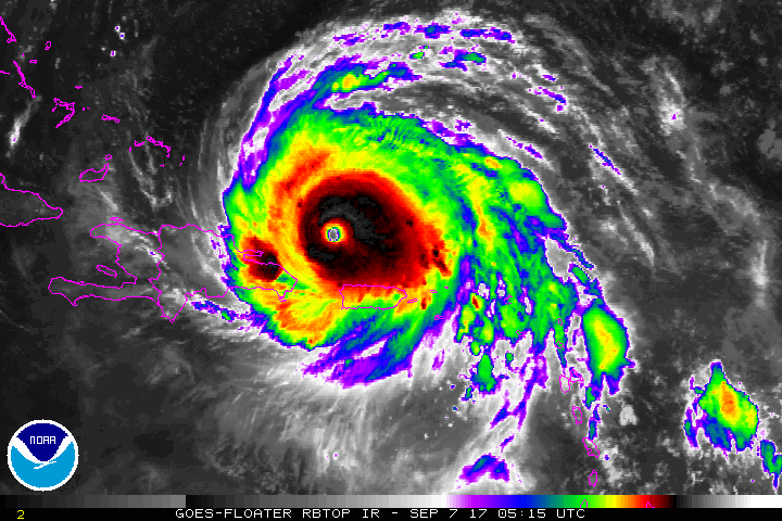
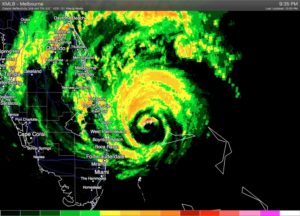
Let’s break this down step by step for Major Hurricane Florence…

  • the intensity should wobble between Cat 4/5 dependent upon eye-replacement cycles
  • the trajectory should take it to the NC/SC border
  • the forward speed should slow and perhaps even stall Florence offshore
  • where a stall might occur will be key as to the extent of wind damage for the coast… a stall offshore will allow Florence to throw wind and rain to the coast and coastal plain (albeit in an eroded state from the Cat 4 status) for 24+ hrs
  • if the stall occurs inland, Florence will be robbed of her energy source and will spin down quickly, with only torrential rains to deal with

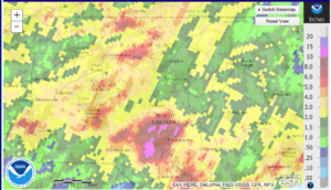
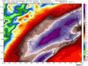
At this point, the model guidance indicates that the slowing forward speed will make it so that Florence won’t be able to penetrate far enough inland for significant wind gusts towards Raleigh.  The uncertainty of the areal coverage of what will be a prolonged heavy rain event is the wild card.

For tonight, confidence is increasing that the threat of damaging winds should be well to the south of the Triangle, in the southern, central and eastern NC.  Flooding rains seem likely to extend northward toward Virginia, however, predicting where those heavy axes will line up at this point is premature.

My big point tonight is that there is a significantly higher degree of uncertainty with Florence than there would be if we had a storm under the influence of defined steering currents.  Continue to stay alert and be ready for a much worse Triangle scenario.  We still have 2 days and 700 miles to go!

Mercy and a Mean Left Hook

We have some good news and some bad news.

The good news… In the battle of mercy armwrestling that’s been going on between the American (GFS) and the European models, the GFS has thrown in the towel and conceded the European’s track guidance of Florence approaching Cape Fear for landfall(?)

The bad news… This is the reason for the above question mark and where the left hook comes in.  The latest operational European run, hot off the presses, depicts the same track, that it has been remarkably consistent with, from the past couple days.  However, this run is a little slower in forward speed.  Consequently, Florence never quite makes it ashore before it loses steering currents.  Then it drifts southwestward paralleling the coast to SC.  So the track plot literally looks like a hard left turn as Florence gets to NC.  This would be horrible, because the hurricane would still have an energy source over water to fuel a prolonged period of winds and torrential rains that would be devastating along the coast.

So, while we’re more confident of the direction it’s coming with a track into the Cape Fear area, the next and probably really difficult thing to discern is what happens when the steering currents are gone and just when does that happen.  The above scenario outlined by today’s Euro is just one possibility that we need to consider over the next two days before Florence arrives.

It’s important not to get fixed on an exact solution yet.  We know that this is going to be a devastating situation for some in the NC/SC/VA, and a widespread bad situation for many.  Everyone in central and eastern NC and upstate SC should stay alert and prepared for the possibility that you could be one of the ones devastated by life-threatening conditions, as opposed to inconvenienced by a bad situation.

I’m still hoping to have more firm ideas on the track by this time tomorrow.


Quick Update Now…More Comprehensive Post Tomorrow ~3pm

There’s not a lot to add to what I posted last night.  The same general thinking applies although, there may be a tendency to shift landfall farther north.

Today, the rapid intensification expected to take place has occurred.  Currently, an eye wall replacement cycle is underway.  It is likely that once this is complete, we will have a Cat-5 Florence heading for NC.

Tomorrow, we can narrow the track cone a bit.  Tonight, things look farther north.  Tomorrow they may look farther south.  But by Wed AM we should be confident in a detailed track.  And as a reminder, that track will dictate the extent of the worst inland wind damage, which will be something like 25 miles west and 50 miles east of center of circulation.  But as bad as all the winds may be, the real widespread threat should rain and tens of inches of it.

More tomorrow…


Florence (to) Henderson

Here’s the story of a lovely lady who was…

It’s too early to know if Florence will fulfill her Brady Bunch destiny and pass over Henderson (NC) or not, but any way you slice it, the chances for a potentially crippling natural disaster across central and eastern NC are on the rise.

Ensemble track guidance continues to converge on a solution that would bring Florence ashore between Myrtle Beach and Morehead City.  But remember, it is important not to focus on the singular point that is the center of circulation.  Significant wind damage will radiate out many miles (especially east and north) from the eye.  And while the fact that Florence looks to be at least category 3 and probably 4 at landfall is concerning from a wind standpoint…what happens afterwards with a meandering storm and its torrential rains is potentially more troublesome for a wider region.

So let’s break this down.  Assuming current trends continue we would expect…

  • landfall near the NC/SC as a low end Cat 4 storm (max sustained winds near 140mph) Thursday late afternoon/evening.
  • after landfall, the center of circulation should continue inland toward central NC and toward the VA border, losing forward speed.
  • tropical storm force winds will be felt across the entire state, and hurricane force wind gusts would be realized along and to the east of the track more than 100 miles inland.
  • widespread downed trees and power outages should be expected with the potential that many of those power outages could last a week or more.
  • without any real steering currents, Florence may meander about NC for a couple of days dumping buckets of rain across eastern NC.  10″ will be common with extremes in excess of two feet, maybe more.

I don’t mean to imply that the above general outline is what everyone will experience.  However, many locations in NC will be affected by these conditions.  Make preparations and alternate plans now so that, dependent on storm track and resultant rainfall maxima, you will be comfortable to ride out the storm, which may last a couple days.

The good news is that we have several days to prepare, continue to monitor track and intensity, and hopefully be able to narrow down exactly where the worst will be as we get to mid-week.


Irma… Hard Right

I apologize for being late to the game in commenting on Irma.  It’s only now that impacts to NC will begin to come into focus for the incredible storm that is nearly 5 days out.

The coverage in the media is comprehensive.  What can I add?  Two things…

  1. Models vacillate.  Don’t look at the last run.  Don’t even put too much stock in the latest runs of an ensemble suite.  Rely on the National Hurricane Center.  They are the experts, literally working around the clock for all of us.
  2. The hard right turn of Irma will be the key in discerning impacts to NC…and we can only guess with model guidance as to when and where that will happen.  This time around, more so than with smoother tracking storms, predicting this hard right turn to the north will mean the difference between devastation vs inconvenience.  Late Saturday will be the tell for how this abrupt change in trajectory will affect the entire southeastern seaboard.  Until then…we can conjecture, we can wring our hands over the latest model runs, but we can’t really know where Irma is going.  Anyone who tells you differently isn’t being truthful.

I’m sorry to disappoint for a forecast for NC.  All I can do is give you my best guess…It seems to me that Irma should have a similar trek up the Florida coast just offshore akin to last year’s Matthew, ultimately making landfall between Charleston and Wilmington overnight Monday into Tuesday AM.  Probably she curves westward after that.  Remember, to the east of the center will be worse for wind intensities.

Again, lots of time to figure it out for NC.  No harm in making preparations now.

Dark Side of the Moon

If Matthew is listening to a playlist, right now he’s probably playing (Pink) Floyd. (insert groan)

Thankfully, the eyewall of Matthew has maintained just offshore through FL.  As it moves northward, I still like the idea that it tracks over water or just grazes the coastline all the way to Cape Fear.  As mentioned last night, this will put eastern NC in a really bad position to receive a lot of rain.  The numerical modeling continues to highlight this threat and is converging on a solution that would produce widespread inland flooding.

I make the reference to Floyd in 1999 as the last great flooding event in eastern NC.  One of the things that exacerbated the flooding with Floyd was the fact that Hurricane Dennis had dumped several inches of rain over eastern NC just 10 days earlier.  This time around, areas around the region, including Fayetteville, are still recovering from flooding last week.

screen-shot-2016-10-07-at-12-20-25-pm

Here is the observed rainfall over the past 2 weeks centered over Raleigh and Fayetteville.


screen-shot-2016-10-07-at-12-38-31-pm


Here are predicted storm totals for Matthew from today’s 12Z GFS.  That’s a lot of rain on top of already saturated ground.


For comparison, let’s look at totals from Dennis followed by Floyd 10 days later in 1999…

fig03


Here’s Dennis…


precip-19990915


Here’s Floyd…


It’s a serious situation to watch over the next 36 hrs.


[Untitled]

Matthew is poised to graze Florida’s Space Coast early tomorrow morning as a category 4 hurricane.  There is still much debate at this late hour as to whether it actually penetrates image-10-6-16-at-10-01-pminland or remains slightly offshore.  It’s the trickiest of forecasts with significant implications to subsequent storm strength farther north up the coast, including in NC.

I’ll leave the nowcasting to your local media outlets as Matthew tracks north.  What I’d like to put out there are a couple of points:

The models have waffled back and forth as to the track.  I’ve always been of the opinion that Matthew will track just offshore from Melbourne, FL all the way north to Cape Fear… mimicking the shape of the coastline.  Models have insisted on a sharp right turn out to sea near Charleston, but this evening’s 0Z guidance leans more towards my camp, suggesting a farther northward motion before the push to sea takes place.  Obviously, this would mean more rain, wind and surge for NC.

No matter the exact track, the interaction of Matthew with an inverted trough along the coast and the impinging cold front from the west, will combine to funnel a ton of moisture into eastern NC.  Indications this evening are that totals could trend higher.  At least 2-3″ in Raleigh on the low end.  More likely to be 4-6″ for us.