Squall line is entering western Wake Co. now with gusts in excess of 50 mph. Get inside and be safe!
« Archives in February, 2014
The Final Curtain
While there are some pockets of heavy accumulating snow, they are the exception and not the rule. Temps are just above freezing and melting is taking place. We will continue to see snow showers for the next several hours, but there should be very little additional accumulation…just a couple of exceptions under really vigorous cells. Again, the summertime afternoon thunderstorm analogy is a good one…general showers with couple of gully washers embedded. So enjoy the pretty postcard snow and be safe. And I won’t even mention the possibility of a little snow overnight Friday 😉 Don’t worry, probably not a big deal for us (we’re probably too warm), but it may be the seed of another coastal storm for the mid-Atlantic and NorthEast for Saturday.
Have Snow Fear…
…if you get a little rain in the next hour before the heavier snow showers arrive.
Short term high resolution models are doing a good job depicting today’s snow. Compare these:
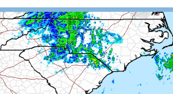
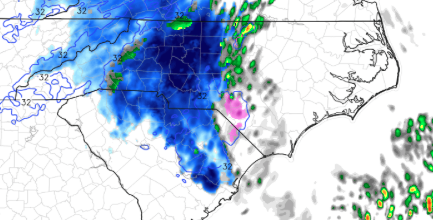
Careful, because the color schemes are different, but at the top are the actual reflectivities (normal color bar from a typical radar shot) and at the bottom the simulated reflectivities from a short term ‘nowcasting’ model (the precip types are color coded snow=blue, pink=sleet, green=rain)
All to say that, I’m believing in a little higher totals at this point. Again, still the highest totals to the north and west, but the Triangle may be able to get 2-3″ generally with lollipops of 4 and 5″ under convective cells. And several reports of thundersnow have come in from the western part of the state. Not out of the question here for us, either.
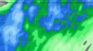
This next picture is of liquid equivalent QPF from that short term model on a super close-up shot centered on the Triangle (look for the county lines). Couple of things to note: the cellular nature of the precip distribution, and decent totals. Here the dark green starts the .3″ contour and the dark blue is .4″, while the second blue contour is .5″ and then each contour goes up by tenths. Bottom line is that this model depicts quite a bite of moisture.
(also, note that if you need these images larger, you should be able to click on them to pop them out of your browser window)
Here we go!
Act III
The patrons are heading back in from the lobby as the entr’acte begins to play ahead of Act III…
For reference, my totals so far from the first two acts are 4.1″ snow, .4″ of sleet and .2″ of ice accrual. The warming to freezing and just above in the eastern part of the Triangle helped tremendously in limiting ice accruals to just a couple tenths. Hence, just spotty power outages this AM.
We should see the final bout of snow move in from west to east near lunchtime. Heavy bursts of snow will be seen with some quick accumulations. The best chances for highest totals are north of the Triangle, but the convective nature of these snow showers will mean that locally there could be some heavier amounts…think summertime thunderstorms and the localized nature of heavy rains with them.
1-2″ in Raleigh is a pretty good bet. But again, with 1-2″/hour accumulation rates in these snow bursts, we could overachieve. I’ll monitor as it moves in and nowcast, as necessary.
Follow me on Twitter @trextrex14 for more frequent updates.
Act II
An impressive thrust of warm air has pushed the surface freezing line all the way into Wake county near Raleigh. But it looks like that’s about as far west as it will make it. Which means that eastern Wake will stop accruing ice, while western Wake accrues through the night. Although, a more northerly flow later may push the freezing line back a little more to the east toward morning.
The near freezing temps will mean that ice accrual totals will fall under the crippling 1/2″ thresholds. Still, western Wake and points west will realize several tenths of ice, which will be enough for power outages, especially as the winds kick up into the 20s with gusts in the 30s.
Then tomorrow as the colder air wraps around the backside of the storm it seems likely that we will see a period of snow showers to the tune of 1-3″ of snow. The farther north, the more likely greater accumulations…something we’ll have to nowcast tomorrow.
Goodnight and here’s to keeping your power!
Act II and III
Act I is about to wind up for those in Wake Co. And by wrap up I mean that the precip rates will decrease and become more showery in nature, and the bigger one is that the snow will changeover to sleet. Difficult to say exactly, but this should happen over Wake Co. from SE to NW. There are reports of sleet mixing in south now. So maybe Raleigh has until 5 or so. Until then heavy snow continues at the rate of 1″+ per hour. Weathertrex headquarters has right at 4″, so this means that Act I will end up delivering more than advertised ranging from 4-7″ up from the 3-5″ progged.
Act II will be showery sleet and freezing rain this evening and overnight. We’ll have to see how the radar fills tonight to ascertain if we will achieve the 1/2 of ice. Will monitor.
Act III is tomorrow with the wraparound bonus snow. Looks like 2-4″
Lots more storm to come! Enjoy and be safe!
And Snow It Goes…
The snow is entering extreme southern Wake Co. at 11:45am. It will arrive in Raleigh within the next hour…right on schedule. And when it begins, it will be significant. Expect snow rates of 1″ or even greater per hour. This will quickly whiten things with a a good several inches before any change to sleet. I’m happy to leave the forecast in place with the caveat of the possibility of higher accumulations on the front end.
With regard to the wrap-around snow expected tomorrow…it’s looking more likely, especially from the Triangle north to VA. A couple inches with that seems like a safe bet.
Steady as she goes. I’m eager to see the Euro’s latest track, which will help with understanding just how much warm air works in.
And Another Thing…
First, I agree with Fishel and his isothermal rant…especially in light of the fact that precipitation rates will be high, dictated by mesoscale banding.
But the other thing I wanted to address is the so-called wrap around or comma head or deformation band. The new GFS continues in the trend of significant supplemental snows in association with this. However, this new run really cranks it up to the tune of several addition inches. We’ll see if there is consistency in subsequent runs and the other models.
And finally, you should be aware of a clipper system progged to dive over NC Friday night into early Sat AM. This system could drop another inch or so of nuisance snow. Just something to watch for now.
Actually as I think about it, we have a growing list of things to watch…
I Wonder If the Triangle Will Be in the ‘Sleet’ Spot
Watching the American models come in tonight, I’m wondering if maybe the Triangle might end up in the ‘sleet’ spot. Here’s my train of thought. I wonder if there will be a relative low in ‘inches of stuff on the ground’ in between the heftier snow totals to the west and the ice accrual glazing to the east. So if there is zone which ends up staying for a prolonged period as sleet, then maybe it actually works out with lower snow/sleet totals and less of the dangerous icing. I’m not saying I know the answer here. Just pondering. Now question this would be a preferable solution with far fewer power outages.
At this point, we’ll just leave the current outline as is, but perhaps the snow might be overdone in favor of more sleet and freezing rain. Let’s look at the new Euro tonight. And then perhaps more exacting might be tomorrow AM’s run cycle when have the benefit of initializations with the storm already in progress. Although, it should be noted that this evening’s runs had the benefit of supplemental hurricane hunter aircraft data from a special mission flown to improve the accuracy of the data-poor analysis over the Gulf of Mexico.
Fun Stuff!
The Main Event
Round 1 is coming to a close for NC, but not before some impressive snow totals were squeezed out, especially in places like New Bern where up to 6″ have been reported. Elsewhere, south of Wake county more general 1-4″ accumulations were observed into the Sandhills.
Today’s snow was a foretaste of the much stronger headline storm that arrives tomorrow. I don’t have big changes to make at this time from previously outlined ideas. The new 12Z Euro shows a slight shift to the east of the storm track, more in-line last night’s Euro ensemble mean. But I continue to favor a track even just a little farther east, which would take it right over Cape Hatteras. This is where I could be wrong, in which case snow totals would be reduced in favor of more ice.
As I’ve said before the QPF (liquid equivalent) is becoming a matter of certainty for this event. Latest SREF (short term ensemble suite) mean QPF is 1.35. The favored Euro 12Z deterministic is at 1.6″ and last night’s Euro ensemble mean was also right at 1.6″. Again, lots of precip to fall. And most, if not all will be frozen.
To review what will happen tomorrow. Precip should arrive in Triangle around lunch in the form of snow. Snow should accumulate several inches before mixing with and changing to sleet. Sleet should accumulate quite a bit before changing to freezing rain. Then, as the low passes there is growing evidence that more snow will occur to the tune of a couple of inches in a formidable deformation zone wrapping about the comma head of the surface cyclone.
Blah, blah, blah…just give me the number! Here’s my thought for Raleigh, which is basically the same as yesterday, plus bonus on the backside. 3-5″ of snow/sleet, plus .35-.5″ of ice, plus 1-3″ of snow Thurs AM in the comma head.
This evening maybe we can talk about what might go wrong…like Gulf convention limiting northward moisture transport and getting dry slotted and a far inland storm track that would cause a changeover to rain even to the Triangle.
Recent Comments