« Archives in January, 2017

Snow Cream Crunch!

A quick update as a blanket response to the thousand questions I’m getting about ‘the latest’.

To specifically address Wake Co. and Triangle…yes, it does look like the transition zone will be over or very close to Wake Co. during the middle of the event.  If you’re rooting for a major event, don’t worry, we’ll get one.  There is a lot of moisture to fall and much of it (after 10 tonight) will fall as something frozen.  Obviously, the accumulation will be higher where there’s less sleet (north) and lower where there’s more sleet (south).  The numerical guidance and meteorologists have done all that can be done to this point in outlining the storm and defining broad boundaries for this transition zone.  What happens now is realtime data analysis to determine over the next several hours where the magic line ends up.img_3282

The message is that your snow cream is likely to have some crunch in it, but look at it as a culinary upgrade, rather than a problem!  Just use more Eagle Brand Milk and you’ll be fine!

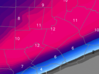
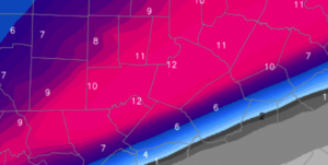
I actually think 6-10″ in the northern half of the county (plus western parts of the Triangle…Durham/Chapel Hill/Hillisborough) is good, while 3-6″ in the southern half of Wake is good.  And while I buy the warm tongue penetrating all the way to northern Wake for at least some of the event, I’m also still a little skeptical that a couple degrees above freezing for a couple hundred feet might not be overcome by vigorous precipitation rates.  That is, if it precipitates hard enough during the height of the storm (which looks likely), then it could conceivably snow right thru any warm layer, creating an isothermal layer right at the freezing point.  Something to watch for…along with 143 other things.

Another thing to think about…all that brine that went down on the roads over the past couple days has really been compromised this PM with the rain.  So, the pretreating isn’t going to help the roads very much.

More updates as the real part of the storm begins.

Addressing the Sleet Fear

It’s true.  The short-term, finer scale NAM and many mesoscale (local) models that are initialed off the NAM, push the warm tongue inland thru Wake Co., resulting in a prolonged period of sleet before snow completes the storm.

A couple of points:

  1. It’s too early to jump on that hypothesis without support from other models (for the record, the GFS (American long term) and Canadian have come in steady with minimal warm tongue intrusion this evening…still waiting to see the Euro)
  2. Even if the NAM solution verified, we are still looking at a formidable winter storm…something like and inch or two of sleet plus and 2-3″ of snow.  This is arguably worse for travel with the more efficient sleet as an icy base with snow on top.
  3. Let’s see more data.  There are other mesoscale models that keep Wake Co. all snow.

No changes tonight to my outline for a range of 6-10″ in Wake Co.

In thinking about measuring accumulations with the possibility of a snow-sleet combination:

  1. Snow and sleet should be measured separately.
  2. If there is any sleet mixed in, it would most likely precede the snow.  However, in the event that any sleet falls on top of the snow, it will compress snow in your backyard vs the official measurement.
  3. Remember that snow would fall with a higher accumulation to liquid ratio (probably 10:1) than sleet which is probably closer to 3:1…i.e. sleet eats up the available precipitable moisture for hydrometeors much more quickly than snow.

And just as I’m about to finish…THE NEW EURO COMES IN…

It holds fast with thermal profiles that support all snow in Wake Co. It also portrays the favored moisture axis a little farther north, such that its totals push a foot.screen-shot-2017-01-06-at-1-12-55-am

So, as I started this post…I’ll hold fast on my 6-10″ range for Wake Co.

Consensus

I have to make this short and sweet…

While there remain some quantitative differences among the various models as to the morphology of the precipitation shield, there is a consensus we will see a significant winter storm beginning tomorrow evening and through Saturday.

As demonstration of the unanimity across the GEFS (American) ensemble members, check out this AM’s run compared to a couple days ago. (again, thanks to WeatherBell for their great graphics)

screen-shot-2017-01-05-at-3-05-03-pm

screen-shot-2017-01-03-at-1-14-04-pmObviously, with each ensemble member producing 10″+ and an ensemble mean nearing a foot, this is the real deal.  The Euro and its ensembles are in similar agreement, albeit with ensemble mean closer to 6-7″.

The trick is figuring out the orientation of the precip axis and then factoring in any warm tongue intrusion that may change over the southeastern boundary of snow to sleet for some or a significant duration of the storm.  These are details to be ironed out over the next day.

But qualitatively, I’d expect Wake county to range from 6-10″ west to east.  Bust potential to the low side is 2-3″, bust to the high side is 12-13″.

It will be chilly on Sat night down to the mid teens, but Monday AM will be brutal in the 0 to 5F range with a solid snowpack.

Quick Midnight Update

I’m interested to see how the model runs come in this cycle and over the next two, particularly.  The upper level energy that will fuel our weekend winter event is just now being sampled on the West Coast tonight.  Preliminary indications show that our thinking is on point.

I’m going to hold off defining snow accumulation zones until early afternoon tomorrow.  However, I will say this…I’m fairly confident that 2″ in Raleigh is a lock.  4-6″ is a prudent forecast.  6-8″ is not really a stretch.  More than 8″+ is possible…not likely.  (Of course, to the alternative, you have to consider that the forecast could bust to the low side.  Best estimation to the low end is 1-2″)

For now, it’s safe to put big money on white ground cover from Durham, East and North.  We’ll sort out details tomorrow afternoon.

Plinko!

Happy New Year!

PLINKO IS THE NAME OF THE GAME

We all remember Plinko from The Price Is Right, don’t we?  And now there’s a new show, ‘The Wall’, that’s basically high-tech Plinko.  In case you have no idea what I’m talking about, here’s a gif to refresh your memory.  A contestant drops a chip from the top of the peg board and it randomly bobbles back and forth, down the board until it lands in money slot.  As you can see $0 is very close to $10K!

plinko-o

So what does this have to do with the weather?  Well, using numerical modeling to predict the weather isn’t as easy as numbers in–answer out.  There are a bunch of factors:  the basic mathematics in the billions of equations being solved, the accuracy of the initial conditions assigned, rounding and truncation errors, and the sensitivity of a particular fluid dynamic setup to chaos.  To mitigate the impact of all these potential pitfalls, modern numerical weather prediction relies heavily on ensemble forecasting.  (Here’s where the Plinko comes in…individual model runs in highly dynamic scenarios is like dropping Plinko chips and getting a different answer each time.) So… we don’t use any one run of a particular model.  Instead, we look at dozens of variations of the same model to ascertain the veracity of the operational or deterministic run of a model.  i.e. if the spread is small among all the runs, you’re confident in the outcome. If it’s all over the place, then you have to tread with caution.

This weekend’s potential snow for the Southeast feels more like a random Plinko board at this point, although some focus is beginning to come.


WHAT OUR PLINKO BOARD LOOKS LIKE

As with all winter weather events, it will be fun to see how this turns out, versus what things looked like from a week out.  If, in fact, NC receives a major snowfall, it must be said that the GFS American model had it first…in both it’s operational and ensembles…altho the run to run variability has been rather Plinko-like.  Over the past couple cycles, the Euro has come on board with the American and Canadian to heighten the threat.  And even as there appears a significant threat for the late Fri thru Sat, things are far from certain and the range of solutions continues to be wide.  It is conceivable for central NC to get a flurry or a dusting, and it’s also quite possible to get a foot.  As with life, the answer maybe falls in the middle…but with the climatology of NC not in our favor…perhaps the answer will fall toward the lower end.

So, here’s an example of what our Plinko board looks like today…some $10K, some $0, some $100.  This graphic shows accumulated snow (and note that these plots show all frozen precip to include sleet and freezing rain in addition to snow) from each of the control and ensemble members of the American suite.  No doubt, there are some exciting possibilities, and yet there are disappointing outcomes too.  (This graphic is courtesy of the good people of WeatherBELL.)  screen-shot-2017-01-03-at-1-14-04-pm


BOTTOM LINE

Central/ Eastern NC has the potential for significant snowfall this weekend.  Perhaps begin planning what you might do differently, particularly on Saturday.  Don’t clean out the grocery stores just yet, though.  Also, be aware of the potential for some sprinkles, flurries or snow showers overnight Thursday that will proceed the more significant weekend system.