« Archives in January, 2014

What’s Next?

I hope everyone enjoyed the snow, even if we were robbed of a couple inches.  And what better thing to do than look ahead to the next event…

Things begin to warm up such that a beautiful weekend is in store with temps in the mid to upper 50s Sat and well into the 60s on Sun before rain comes in late.  Then there’s a cool down, and second storm, mid week that we’re again on the warm side.  But maybe the third storm is the charm for next weekend with something brewing out of the gulf for another NC snow special.

Obviously, a long way off and just something to keep an eye on for now.

And Snow It Begins…

Things still look on target for snow to begin in the Triangle between 3:30 and 4:30pm.

Let’s not get ahead of ourselves before the first flake falls, but some of the short-term/high-res ‘nowcast’ modeling is indicating the potential for higher totals in the the Triangle, especially Wake county.  Let’s not up our totals just yet, but just say that the 12Z Euro came in a little wetter, and now the RAP is more bullish.  So while the large totals are still a longer shot, there are decent chances on the table for a major event this far west.

Just for fun, and because I know you children like pictures…here is the RAP snowfall accumulation map that assumes a ratio of 10:1.  Remember that I’m expecting ratios at 12 to 15:1.  So, if this solution verified you can bump the Raleigh value of 7-8″ up to 9″-12″.  (for reference the first purple contour is 7″, the dark blue is 3″…again, assuming a 10:1 ratio)

Screen Shot 2014-01-28 at 2.19.09 PM

Again, I show you this kind of stuff just for fun.  This is not a forecast.  Just an example of one of many products that the meteorologist has to ingest before coming up with a forecast.

GameDay

Happy Snow Day!

In a continuation of the theme from last night, it would seem that southern sections (like FAY) will be influenced by a mid-level intrusion of warmer air such that a period of sleet and possibly some freezing rain will reduce their snow totals.  At the same time, this influx means more overall moisture transport farther westward.  So, what looked like a sharp back edge to the snow totals a couple of days ago, now looks more broad.  There still looks to be a relatively sharp axis where generally light snows will ramp up to a band of heavy snow in northeastern NC.  There is some concern about just how dry this arctic air mass is and the loss of some snow totals that will go to saturating it.  Fair enough. Just another of the questions that linger as we get warmed up in the pregame.

Here’s my new outline…5-7″ in central Raleigh, tapering to 3-4″ in Durham, back to 1-3″ in INT/GSO.  Then going east, we ramp up from Rocky Mount to the Tidewater where it’s 8″ up to 12″+.  For the second storm in a row, the big winners are in northeast NE.

You see the theme here…farther east more snow…farther south more sleet.  We’ll see how this all plays out this afternoon after kick-off.


Steady as She Snows

Not much in the way of changes in the thinking for the event.  A couple of points, tho…maybe, in general, more moisture farther west, which also implies a little more mid-level warm air in the south and at the coast.  This means maybe bumping snow totals from the Triangle and west, and looking for more ice at the coast and having to worry about a sleet zone in the south.

For now, i’m happy to leave my outlined totals where they are until I see what the Euro looks like when it comes in after 1am.  In a previous life I probably would be making changes now, but there’s still plenty of time to reevaluate to the upside on snow near the Triangle and adding ice south.

The Trend is Your Friend

Last post was before the Euro came in.  Thought you’d like to see the comparison of snow totals from last night’s run (top) to this AM’s (bottom).  Note that this uses a standard 10:1 ratio for snow conversion, so you might expect a little higher totals on the western edge if the the QPF verified.Screen Shot 2014-01-27 at 1.15.15 PM Screen Shot 2014-01-27 at 1.13.35 PM

Run to the Grocery!

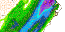
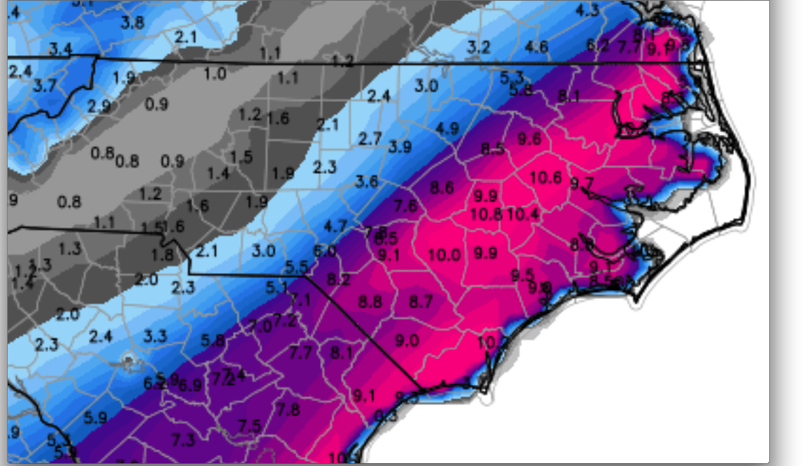
The picture is becoming more clear with more consistency among the different models as to how the event will evolve, even as exact QPF morphologies may differ.  This is to say with growing confidence, accumulating snow is likely from the Triangle and points east.  And of course, everyone wants to know if that means 1″ or 1′.  In truth, both of these solutions are possible for Raleigh, and both these solutions will likely play out somewhere over eastern NC.  Let me reiterate what I said yesterday about the sharp gradient to the western periphery of accumulations.  It is quite likely that over the distance of something like only 20-30 miles you could have variance from a dusting to 4 or 5″.  One of the factors that will also aid in larger accumulations should be the arctic air to the west, which will act to increase snow ratios.  At the same time the arctic air is very dry, which acts to erode away the good moisture feed on the back edge.  Hence…a sharp cut off.

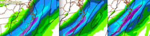
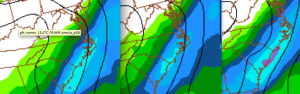
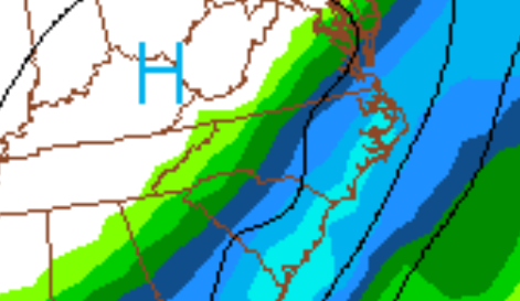
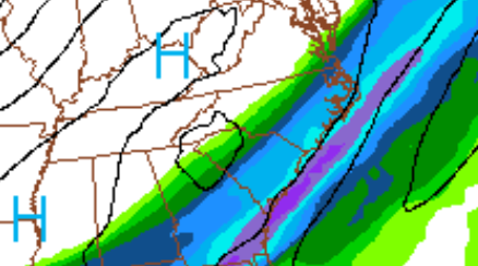
Just for fun here are the last 3 runs of the liquid equivalent for the NAM (above) and GFS (below).  The leftmost plots are the newest.  You see the NAM has backed westward, while the GFS has trended eastward to give decent spatial agreement, even if the orientation of the band is somewhat rotated.

Screen Shot 2014-01-27 at 11.20.51 AM Screen Shot 2014-01-27 at 11.25.25 AM

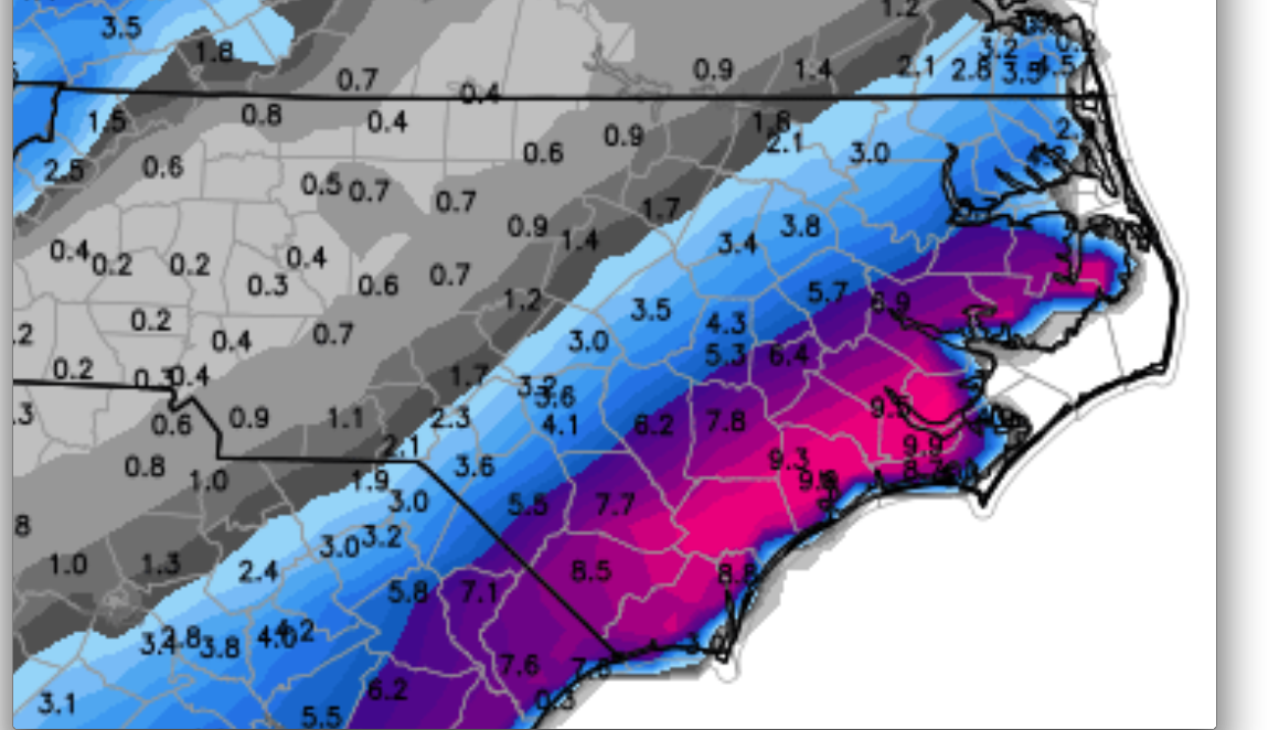
What you want to know is a number, though.  Right?  What’s in my backyard?  OK, I’ll bite.  FIRST GUESS – 4″ in central Raleigh, tapering to 1″ west to Durham and increasing to 8″ in Wilson.  Make your own extrapolations from these guideposts.  Again this is a first guess.  I’ll revise tonight and again tomorrow.

Finally, note that the timing of this event is moving up a bit from what was first progged.  The accumulating snow could begin as early as tomorrow mid-afternoon, with most of the snow tapering off southwest to northeast just after midnight.

The National Weather Service will upgrade the watches to warnings this afternoon. So it’s time to do what all good southern boys and girls do in a situation like this…RUN THE GROCERY!!

Beware When the Models Go Gangbusters

Quick note to say that the latest 0Z American models continue with their over-the-top fantasies of what would be an historic snowstorm for eastern NC.  It’s a great dream that we can all have fun pretending will happen, but realistically, you have to be very skeptical.  Just for fun i’ll show a couple pics to give you sweet dreams…

Screen Shot 2014-01-26 at 11.43.53 PM Screen Shot 2014-01-26 at 11.44.25 PM

These are 24-hr liquid equivalents from the GFS and NAM operational runs tonight.  The dark blue represents .5″ and the 2nd light blue 1″.  Rule of thumb is 10:1 snow to liquid, but for us with the airmass as cold as it will be, expect ratios of 15:1, maybe higher.  I’ll let you do the math.

Enjoy the dream, and maybe things will pan out.

Confidence Increasing for Mid-Week Snow

Lots of questions still to be nailed down, but if you live from the Triangle and east, the chances to see snow late Tues and Wed are increasing.  This looks to be the rare Eastern NC special.  A couple of things seem relatively clear: 1) the predominant p-type will be snow,  2) the farther east, the higher the snow totals, and finally 3) there will be a relatively sharp gradient along the western periphery of the precipitation shield.  The trick will be figuring out where that back edge for those getting a dusting and the lucky ones only 50, 75, 100 miles east who get thumped with >6″.  Lots more time to nail it down.

Wide Right or Thru the Goal Posts?

A quick update on the mid-week event…

This has always been the case of how close to the coast will the surface low track and consequently, how far west will the moisture shield extend.  For a couple of run cycles yesterday, the models were in major poo poo mode with most whisking everything out to sea.  Now things are coming back west and we can begin to play the game of “will it miss wide right?”  Agonizing to come over the next couple of days…

I’ve Been Snow Busy

I’m sorry to have not been commenting on the weather of late…combination of busyness and vacation, coupled with the fact that there really has been nothing to comment on from a snow perspective.  Until now…

So let the snow mongering begin!  It’s a long way off, but our first shot at a respectable snow storm comes next tues and wed.  (and maybe a second something for the weekend following)

Let’s leave it at that for now as the vicissitudes of life whisk me away again.  But I promise to update on this threat as our first real prospect of the season!