« Archives in February, 2020

I Was Wrong

Couple of things…

1) the antecedent ground temperatures really held their own — while it was snowing really hard, it worked. but now the precip rates are winding down earlier than anticipated, which brings me to…

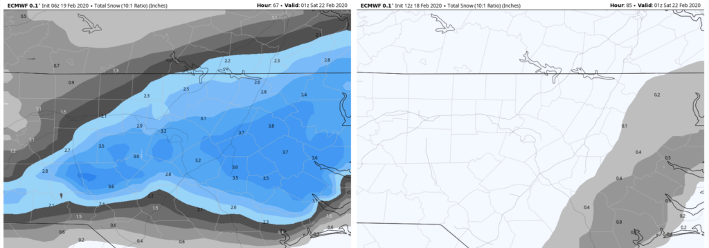
2) the axis of enhanced moisture never extended as far north as advertised— that means that the NE corner of the state that was expected to be the winner will end up underfed. In Wake county, while the snow coming down now is lovely, there will be little to no additional accumulation.

Still the temps will drop well below freezing tonight and all that slush on the roads will be treacherous tomorrow. The question then becomes how much melting and evaporation do we get tomorrow…should be a lot… to prevent more back ice on Sat AM when temps will plummet to the lower 20s.

Then… guess what… I’m watching the potential for another winter event next weekend! Fun times. Enjoy!

Snow…Pack!

Looks like the Pack victory was a good call! Now onto the snow to complete the “snow-pack”!

Precip should begin arriving not too long after lunch. With dry air rushing in on the back of a stiff NE breeze, any rain and sleet should quickly change over to snow. As we approach rush hour, the intensity of the snow should pick up and we should be in for a beautiful snow thru the evening.

Let’s say 3-5″ for Wake county. Again, the real winners look to be east where it should be 8+. Back towards Greensboro and Charlotte look for more like 1-2″

Looking ahead, Saturday morning lows will be near 20. That hard freeze will make for bad traveling on whatever is on the roads.

Short Term Models Looking Good

I thought I’d push a quick post 1) as another test that my website issues are resolved, and 2) because I won’t get to update until after the Wolfpack beats Duke in the late 9pm game tonight!

The models continue to come in, in support of a significant winter storm in central and especially, eastern NC. The short term ensembles are impressive as well.

I still like the axis of heaviest snow to line up from Raleigh and extending northeastward toward Norfolk. I feel more comfortable with the idea of something closer to 4 or 5″ in Raleigh with higher totals in that Rocky Mount to Edenton zone nearing 8″.

More tonight, after the Wolfpack’s victory. 🐺

Euro Rights the Ship?

I’m sorry to not have posted until now. There were technical problems with the website. (perhaps I was hacked by the Europeans so I couldn’t poo poo their model 😉

While certainly it is too early to declare an American model victory, what can be said is that the deterministic Euro and its ensembles have steadily ticked up from 0 to 3+” for central and eastern NC over the last 4 runs. It should be reiterated that the Euro skill scores are statistically superior over all global models, but as they say… you can’t win ’em all. That appears to be what’s going on here.

Comparison of Euro snow maps from yesterday 12Z to early this AM at 6Z

Snow looks likely for a good swath of NC tomorrow thru early Friday AM. The NAM, while maybe overdone, has displayed remarkable run-to-run consistency. It is insistent on strong frontogenetic forcing which would drive heavy precip rates. Those heavy precip rates will be key in overcoming warm antecedent ground temps.

A concern with all this strong forcing is how far north the warm nose will extend. The warm nose (elevated layer of temps > 0° C) will turn snow over to sleet and reduce totals in those areas. Right now it looks like the warm nose will make it no farther north than central to southern Wake county.

I’d like to digest the complete set of 12Z model runs before passing judgment. And, of course there’s a problem with the GFS coming in this cycle. At this point it’s about an hour late.

The skinny… Precip starts late tomorrow AM as rain or rain/snow mix. Changes to snow for a good chunk of NC. Mixes with and changes to sleet in the south. Storm totals highest from Raleigh north and east. Raleigh is probably 2-4″, up to 6-8″ toward Rocky Mount and to Edenton.