« Archives in March, 2015

There’s No Way to Avoid the Ice

Any way you slice it, tonight will be icy.  Even if you dodge the bullet of sleet and freezing rain this evening, there will be a ton of water left around to freeze as temps fall to around 20.

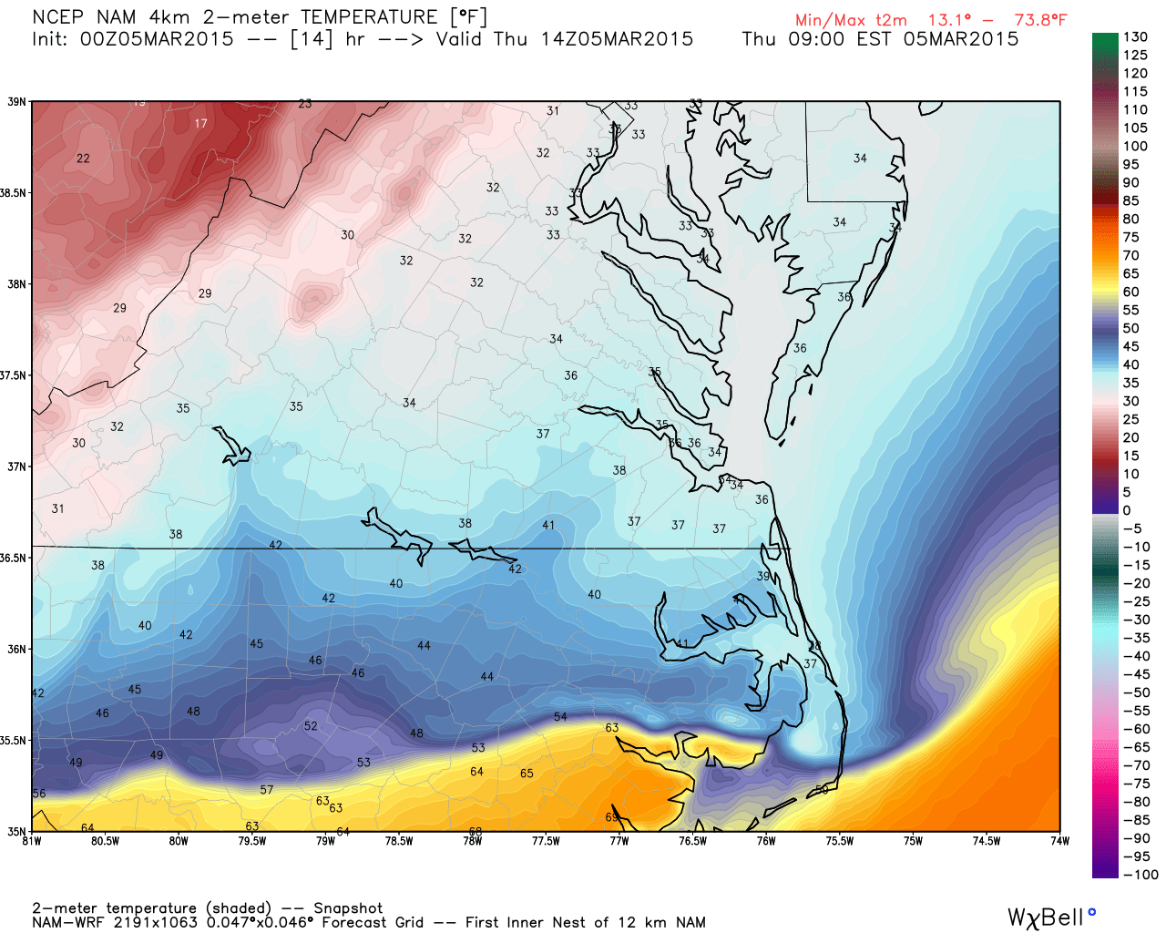
An impressive surge of cold air has been dropping temps more than 20 degrees over the course of just 2 hours. Temps are running about 36-37 in the Triangle with 34 numbers showing up in the counties just to the north. I don’t expect the Triangle to hit freezing until at least 8pm. So there’s probably not going to be a great deal of freezing rain, in favor of some minor accumulations of sleet.  However, the heavy precip is over and what will come thru in the next couple hours will be lighter than what we saw earlier today. So, look for a lull in the precip for another hour or so and then sleet showers mixed with freezing rain…maybe a little snow late?

Sleet falling will be more efficient in cooling the surface and especially warm roadways. This will set the stage for hazardous roads once the temps get a few degrees below freezing.

So, expect minor sleet accumulations and maybe a little glaze in the trees and elevated surfaces. But the real story will be icy roads as the evening wears on and especially as near that low of 20.


‘Siri’ously!

This evening’s post was my first attempt at posting via mobile.  So I used Siri to lessen the typing.  And then I didn’t have time to proof.  I’ve corrected the post now, but there were some funny things!  Ha!

How’s this for a front! (valid tomorrow AM)

hires_t2m_norfolk_15The latest American models continue a wintry threat, if even a bit less bullish.  But there’s really not an appreciably significant difference.  Tomorrow, as the time horizon of interest comes into range of the  high-res short-term models, we will evaluate along with radar trends to see how many problems we’ll have.

HOUSEKEEPING ISSUES…some of you have voiced concern that you have not been receiving emails when I update the site.  I’m not sure what’s wrong, but will look into it.  In the meantime just check back to the top page (don’t use a link from an old email because it will mostly likely take you to a specific post).  Navigate to weathertrex.com directly and you will always get the latest post.


More Significant Event Possible

As hard as it is to imagine with springlike temps well into the 70s, winter make a triumphant return tomorrow. The cold front is spectacular. It will come through later tonight and the real cold air arrives tomorrow during the day. Temperatures will fall through the day such that by late afternoon temperatures will be near freezing. The sooner you get to freezing the more time the moisture has to work with the cold air. So this event will set up with the highest ice accruals and sleet accumulation in a north to south gradient.  The models are trending a little wetter with the backend moisture over the past couple of days, such that now much of the northern half of NC will see at least some freezing/frozen precipitation.

It looks like there will be combinations of freezing rain and sleet as the predominant P-types when the rains changes over. Determining how much of each of those you get will drive how impactful the storm will be.  If it’s predominantly freezing rain, it will take longer to cool the very warm ground temperatures from today’s beautiful weather. However, if there’s an appreciable amount of sleet involved, then roads will become impacted much sooner.

Overnight lows tomorrow evening will be in the upper teens, so black ice will be a problem regardless of if it freezes on contact or freezes later overnight.  Best guest for Raleigh will be up to a 1/2 of sleet and 1/10″inch of glaze in the trees and elevated surfaces. Durham may be a little higher on those totals. And certainly towards the Virginia border and Roxboro… They will see the most significant impacts from this storm.

Lots of time still to watch, and watch we will. Looks like another snow day for the kids on Friday.

Cold Chasing the Wet

As I mentioned before, this will not be a good setup for a significant event.  However, it does seem probable that the rain will change to sleet and maybe some freezing rain late Thursday as the cold air invades.  Big changes from the 70s tomorrow to falling temps thru the day on Thursday.  Ground temps running higher will help limit any appreciable accumulation.

Will continue to watch as we get closer, of course.  It will be a borderline situation no matter how you slice it.

Heads Up!

I know we’re not used to it, but tomorrow will be your one day with the sun out that’s above freezing!  Yes, Wednesday could be pushing 70 (with rain)…and that’s where the fun begins.  We’ll get a roaring southerly flow ahead the next blast of cold air.  And it looks like as the cold front comes thru, it will stall just along the coast.  So markedly colder air will be infiltrating NC as a wave of low pressure uses the frontal boundary as a guide to move north with more moisture.  If this scenario materializes, we would see rain change to sleet and eventually to all snow later Wed night into Thurs AM.

Screen Shot 2015-03-01 at 7.56.02 PM

A couple of caveats…it’s 4 days out, this is not a typical snow setup for NC, we will have warm temps ahead of the front earlier in the day and it is now March so sun angles are really climbing.  Having said all that…the GFS has been pretty consistent on insisting this and there is support from the Euro and ensembles.  What’s two more snow days among friends?!?!