« Archives in January, 2016

Next Round

The back edge of the steady precipitation shield is exiting the Triangle now.  There will be a lull for a bit before the next more showery, quasi-convective band makes it’s way thru this evening.  This band should be accompanied by moderate to heavy sleet/snow showers and even a rumble of thunder to two.  In fact, since it will be dark, you’ll probably be able to see the lightning go cloud to cloud.

So, expecte sleet and freezing rain in the lighter showers and when the precip rates pick up in the convective cells that’s when you’ll see a snow/sleet mix.  There could be another inch or so of accumulation, plus the potential for another tenth or so of glazing before things wind down later tonight.

Then tomorrow expect to see off and on flurries with the potential for a dusting to an inch or so more snow.

Enjoy the winter wonderland!  The glazing of the trees is really beautiful (until it crashes on your house, of course!)

The ‘I’ce Have It

Looks like Raleigh has taken another perfectly good snow opportunity and thrown it down the tubes for an ice storm.  I feel like Lucy has just ripped the football out from us again.lucy2

Oh well, it is what it is. At least the ground is white and pretty.  We have missed the window for real snow and are now into the sleet freezing rain window.  Expect more of the same…sleet showers, mixed sleet and  freezing rain. Then later in the afternoon we’re likely to have mostly freezing rain predominate.  It will be showery…off and on, and some could be of moderate intensity.  Surface temps are running in the upper 20s, which should make for efficient ice accrual.  Still expect temps in Raleigh to edge up right to the freezing point at which time ice accrual becomes less efficient.  Still, watch out this afternoon as things begin to glisten and ultimately topple over.  1/3″ of ice looks pretty easy to achieve, maybe 1/2″.  More later on…

Steady as She Snows…

…and Ices!9e3d1b35ac45742cf5745c992b30699b.620x388x1

I’m happy to make this short and sweet this evening.  While we have this latest model, and that latest model…the guidance balances out to warrant holding steady with my current thinking.  With that said, it’s worth reiterating that the gradient of snow (and sleet) totals will be steep.  Knowing where the transition zone sets up will drive how the totals map ends up being draw.  Unfortunately, the state (limitation) of the science today is that we cannot honestly make those sorts of quantitative pronouncements.  We can, however, qualitatively say what the accumulation distribution will look like and refine the transition zone in a nowcasting mode.

To boil it down…my forecast for Raleigh of 3-5″ snow/sleet plus 1/4-1/3″ ice glaze plus 1″on Sat is good.  Can I see downside risks?  yes!  Can I see upside risks? yes!  Has tonight’s numerical guidance provided a clear direction?  no!  So let’s see how things evolve tomorrow AM.  They key will be how long we stay snow and/or how much sleet mixes in.  If we’ve begun mixing sleet by 10, then the lower end totals will rule.  If we keep predominantly snow thru after lunch, watch out.

Finally, to reiterate…for simplicity I’ve made just a Raleigh forecast.  You can extrapolate to other locations with the simple rule of thumb of… more accumulation north and west… less accumulation and more ice potential south and west (use the coastline as the angle for the line orientation)… moreover, there is more risk to change over to rain south and east.  


Major Winter Storm Imminent

As complicated a forecast as this is for central NC, I’m thankful to not have to worry so much about the battle raging over the northern extent of the major snow axis in the Megalopolis!

At midday, I’m comfortable with the previously outlined ideas for precip types and timelines.  In yesterday’s post we talked about how inches of frozen stuff on the ground would vary wildly over relatively short distances owing to duration of each precip type.  So the forecast that I’m going to outline now will be for Raleigh.  Then we can hand wave later for other locations.

Here’s what I think happens…Precip arrives tomorrow 4-5AM in the form of snow.  We should be able to achieve 3-5″ of mostly snow and sleet before early afternoon. Then it sleets for a bit before changing over to freezing rain. The tricky part is figuring out how much freezing rain accrues.  Complicating factors that will limit high totals will be the anticipated heavy precip rates and surface temperatures close to freezing (i.e. not in the upper 20s).  These things are in our favor as a limit.  Favoring greater accruals are indications that the warm nose might not be as pronounced, i.e. the temperature at 850mb (about a mile up) might not be as warm as first thought. This is the trickiest part…deciding how long we have sleet before the change to freezing rain.  My best guess is to say we add 1/4″ to 1/3″ of glaze.  It is also possible that we briefly pop above freezing for an hour or so late evening tomorrow. (remember that freezing rain is a self-limiting process, which actually releases heat into the atmosphere. so each time a rain drop freezes, the air get slightly warmer.  if you don’t replace that ‘warm’ air with more cold it eventually heats up)  So, if we’re dumping a lot of rain and freezing a lot of rain we’ll probably warm to at or just above freezing before the colder air sweeps back in behind the storm.  Once the main precip shield exits tomorrow evening we will be dry slotted for several hours and wait for the elusive wraparound snow.  I’ll go conservative on that for now with an additional of snow Sat, but some folks could easily get up to 3″ if it really works out.

Let me summarize succinctly… For Raleigh, precip begins just before dawn with 3-5″ of snow/sleet before an afternoon changeover to freezing rain, which adds 1/4 to 1/3″ of ice, followed by a lull until Sat AM for another inch or so.

There is definite potential for more upside on the “white stuff on the ground”, but also a definite downside risk as well in the case that freezing rain to predominates.

Also remember that there will be impressive cyclogenesis taking place on the Carolina’s coast and as such, winds will begin to pick up.  So expect gusty winds in combination with trees and power lines coming down from the weight of the ice.  Make sure to you have batteries and candles.  And make sure to charge your mobile phones!

Screen Shot 2016-01-21 at 1.59.00 PM

Storm total QPF (predicted liquid equivalent)

Short Update

NAM was warm…a definite outlier.  If it is a contrarian, I’ll trust it when we’re 12-24 hrs out, which is close…but remember last year’s debacle in NYC for the feet of snow that never came.

The GFS was qualitatively the same…steady as she goes.

Euro won’t come in until after 1am.  imgname-assessing_the_future_of_venture_capitalism-50226711-flickr_2521098846Other thoughts…

Friday AM, I bet we’ll start to fret over Gulf Coast convection that may ‘rob’ northern moisture transport.

Then, Friday night we have to worry about dry slotting, which is likely to happen.  Following, the question becomes…will there be the elusive ‘wrap around’ snow showers as the storm exits?

Points to ponder.

More infö tomorrow…


Evening Musings

Hope you enjoyed the quick snow flurry this evening…just a harbinger of things to come!

No new information yet as the evening model runs will trickle in over the late evening, but there a couple of other points to drive home while we wait.

When you have the potential for more than 2 feet of snow, it’s fun to anticipate a blockbuster event.  And it’s especially fun when those totals will be relatively close by and/or near major metropolitan centers.  This is going to be a big storm that impacts millions of people.  And while extreme totals are cool to talk about, I think it’s important to remember that in terms of covering the ground and roads…2-3″ of white stuff (snow, sleet, freezing rain) is about all you need for a ‘successful’ NC snow.  And really, it’s not appreciably different from 4 or 5 or 6 or 7″.  It just takes longer to get rid of afterwards.  Of course, when you approach a foot plus, things get more complicated.

Interestingly, the high res GFS ensembles have been the most bullish on higher snow totals nosing down into NC even more so than the Euro.  As I mentioned in earlier posts, there is good consistency in the ensembles suites for a significant event.  See this image, which is a collection of the thumbnails of all 21 ensemble members of the GEFS (American) for accumulated “total snow” for the storm.

Screen Shot 2016-01-20 at 9.16.18 PM

Remember to not take the scale literally because the way snow and frozen precip are treated and accounted is complicated to interpret.  So, use this as a qualitative broad stroke depiction, not a quantitative metric.  That being said, the latest (18Z) ensemble mean pushes the 1 1/2 ft line south of the NC/VA border past Roxboro and Henderson.  Again, it is not likely to be all snow there, but…  Also know that there will be steep gradients on the southern (and northern) precip boundaries where accumulations go from nothing to something to a really big deal over just 50 miles.

Finally, keep in mind that for many people in central NC, the storm will go snow to sleet to freezing rain (maybe rain too) and back to snow.  After the initial snow falls it will be compacted by the heavier sleet that falls on top.  This may cause some shock for those who get 2 or 3″ of snow and look out a couple hours later to see that their accumulation has shrunk to only an inch or two with the sleet on top.


Time to ‘Watch’

The NWS has issued a Winter Storm Watch, so let the games begin.

First, it should be noted that the numerical modeling has been pretty good with its handling of the storm over the past several days.  Not that there haven’t been changes and trending. But qualitatively, most of the global models have been consistent in depicting a blockbuster storm over the past week.  The battle has really been to discern if the storm track is to be more northerly or southerly.  As we approach gametime, the southerly track looks to be the winner.  And for central NC, a more southerly track means being on the colder north and west of the storm track.  What was depicted as a 35° rainy depression a couple of days ago, now looks to be a classic NC winter storm with all the forecasting challenges associated with a Miller type B storm evolution, cold air damming and four different precip types.  Not to sound like a Facebook relationship status, but…It’s complicated.

As outlined a couple of days ago, the general storm evolution for us will be that of coldest on the front and back ends with the questions of how much warm where and for how long in the middle.  Those answers drive the ‘what’s gonna be in my backyard?’ precipitation forecast.  I’ve also been reporting that the trend of the numerical guidance has been colder.  And that still continues, altho with much less dramatic correction than before.  For instance, this AM’s Euro deterministic keeps all of Wake Co. at or below freezing for the entire event.  Additionally, the depth and northward penetration of the warm tongue was scaled back.  All this indicates that snow and sleet might be the predominant p-types for longer, which would limit ice accrual from freezing rain.  Again, the Euro is still colder than the American GFS, but both the Euro ensembles and the GEFS ensembles are in impressive qualitative agreement.

Freezing_New_Mid

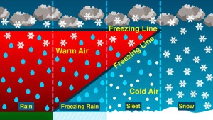
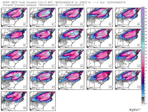
Everyone wants to know how much.  Let me put forth a first guess for Raleigh.  2″ of snow before a changeover and/or mixing with sleet.  The sleet will compact the snow down as it adds another inch or so.  Then we add a 1/10th inch of glaze from freezing rain. And finally as we change back over to snow on the back side on Saturday we add another inch or two.  So, a relatively conservative first stab is 3-5″ of miscellaneous wintry stuff.  More snow/less ice north and west will yield impressive totals of over 2 feet in the northern NC mountains through central Virginia, and with 1 foot totals possibly as close as just north and west of Greensboro.  South and east of Raleigh accumulations ramp down pretty quickly as freezing rain could be the major concern, but a changeover to all rain in the middle of the storm for these folks would limit the severity.

Still 36 hrs to see where the models exactly converge and the aforementioned transition zone sets up.  Obviously, a continued trend to the south with the storm track will bias snow totals higher.  A reversal of the track to jog more north would limit accumulations as a changeover to rain becomes more likely.  I’ll try to draw up a forecast map this evening to help you visualize.

More late tonight on weathertrex.com.  And for more frequent comments follow me on twitter @trextrex14.


Today’s Snow

I’m working on a more comprehensive treatment of Friday’s storm and will have that out soon.

First up, though, a quick note about this afternoon/evening’s show showers…we should expect some flurries in the next couple hours ahead of a more organized band of snow showers that should impact the Triangle closer to dinner time.  Again, this will mostly be spectacle snow, but there could be a few bursts that would get some lucky folks a 1/2″ maybe?  The sun will have set and it’s been cold, so there could be some slick spots out there.  Take it easy. (Glenn Frey, RIP)

more soon…

Caught Looking Ahead

In bad form akin to say the Panthers looking beyond the Cardinals to the Super Bowl…I failed to address tomorrow’s snow potential while dreaming of the bigger deal down the road.

content_snowflake-001

Quickly…the air is quite dry.  Tomorrow we have a weakening system approaching from the west, struggling mightily to make it over the mountains.  Not a recipe for significant snow.  However, with things being so cold (another low tonight in the mid teens…and today being just the first day in the last 70 or so years that Raleigh had a subfreezing high without snow), anything that falls should ‘stick around’.  It looks like Raleigh is pretreating roads, so we’re not looking at the debacle of 2005 again even if we get lucky and a flurry blossoms into a quick burst.  Enjoy the snowflakes in the air and any slight accumulation… a couple of tenths at most.

Move along. Nothing to see here.

One Run Doth Not Make a Forecast…

…but it sure can stir one’s hope.  The new 12Z Euro is just what winter weather lovers want to see in NC and VA.

I don’t want to go on about details of this model run and that model run because there really is no point.  What I can tell you with certainty is that this afternoon’s best guess accumulation map would be different (and likely appreciably different) from any final guess maps issued on Thursday night.

So let’s talk about trends.  Being a meteorologist is just like being a stock picker…the trend is your friend!  (Of course, when the trend reverses is when you lose $$!)

The-trend-is-your-friend

As referenced above, what is of most significance today is the southward shift of the storm track in much of the numerical guidance.  The 12Z Euro had quite a significant push to the south, which puts central NC in deeper colder air = more frozen p-type.  The Euro has been in the colder camp from the beginning (especially vs the GFS American model).  Today we’ve seen the GFS begin to acquiesce to this colder outcome.  What is really surprising is to see such a decided swing in this latest run of the deterministic Euro.  And while there is also support among the Euro’s ensemble members for this shift, I’m skeptical until we see what tonight’s run shows in terms of continuity.

Make no mistake. This is the trend you want to see for more snow in NC.  The latest Euro keeps RDU just at and below freezing thru the entire event.  But, you’d like to see the storm track sag even another 50-75 miles south for the real crazy snow action to invade NC.  Something tells me that tonight’s run will come in and give back some of this southerly advance.  Should be a fun couple of days to sort this whole mess out!

And as I said last night…while the track is uncertain, what is likely is that this will be a very strong, headline-grabbing storm that will end up causing quite a bit of damage with coastal flooding and erosion in addition to crippling millions of people under 1-2 ft of snow.