Yes, it looks like there will be some minor icing tomorrow AM. But this will not be a major event, if fact there should be few if any problems in the Triangle. It looks like the rain will be light and patchy in the early AM and thru mid morning when temps will be below freezing. That being said, anything that falls should freeze easily in the trees and elevated surfaces. It’s just that there shouldn’t much until later when the temps should rise above freezing. Heaviest icing will be west of Raleigh toward the Triad where more moisture is expected sooner. For Raleigh, expect a light glaze at the most. Roads should generally be fine, but as always watch those bridges and overpasses first. We’ll watch it tonight to make sure nothing changes.
11:45 update
Happy Snow!
If nothing else, it’s pretty!
Heavy snow will arrive in Wake Co. over the next 2 hours.
Wake County looks to be just on ‘the line’. Southern Wake might only achieve 3, 4, 5″? while northern Wake may achieve 8-10 or a foot. Or…will the transition zone creep even farther north another 30 miles, as some of the latest short-term modeling indicates?
Hard to say. What I will say is that 4″ is a lock for most in the Triangle and north.
The 0Z models indicate even more liquid equivalent. If that’s right, then there’s more room for any mixed precip in the totals to still allow for earlier snow outlines, even if the wintry mix transition zone flirts farther north into the Triangle.
Epic Snow
At the risk of ‘jumping the shark’…sing this to yourself…(to the tune of Let It Go)
 Epic snow, Epic snow!
Can’t hold it off anymore
Epic snow, Epic snow
By the end you’ll scream…no more!
The snowstorm that many in NC dream of is potentially lurking just around the corner.
The main question mark is…how far north does the warm tongue penetrate? This could cause a 6″ or more differential in snow totals. The trick in nailing this forecast will be accurately assessing how far north it gets. Just to the north of that will probably be the axis of heaviest snows.
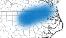
What if the forecast is a bust…I think the low end bust potential for the Triangle is 4″. However, I think the Triangle will probably end up at the southwest corner of the swath of heaviest accumulations. (See the graphic). In this axis, accumulations of 7-10″ are likely. But there is potential for more than 1 foot. As I said last night, to the south of this band, the gradient to light accumulations will be much sharper than to the north.
The models are in complete agreement for copious QPF (liquid equivalent) for the event. For Raleigh, 1.25″ of liquid equivalent is the consensus. Knowing we’ll begin as rain and be above freezing, let’s take away 0.25″ to rain and melting at the beginning. Then, take away another .2″ to account for any sleet and freezing rain that might mix in. That leaves you at .8″ –> 8″ at 10:1 or about 9.6″ at 12:1.
(There is one little fly in ointment for realizing all this QPF that I’ll not discuss yet, but will watch and talk about later tonight, if necessary.)
What to expect…this evening, rain will breakout 6:30-7:30pm and change to heavy snow between 9 and 9:30. There will be times overnight when it snows 1 to 2″ an hour. We’ll be watching that warm air to see how far north it makes it. But any way you look at this, it’s going to be a major event. Enjoy.
No Changes
The same caveats from earlier apply…we’ll see if we stay 100% snow for the event to realize max snow totals.
Tomorrow should be a good opportunity to get out during the day. No trouble until late night Wed.
The Now and Later
ABOUT THE NOW…
From an accumulation point of view, a call of a dusting to an inch wasn’t too bad. The better call was to bite on the later guidance suggesting slightly heavier amounts and call it 1/2 – 2″. Today’s snow actually seemed like more than it was because…1) it was very cold this AM, which initially made for efficient laying on roads, and 2) all it takes it about 1″ to cover everything in white and it looks more impressive than it really is. Snowfall reports around the Triangle were lighter towards Durham (1/2″) and heavier in Wake Co. (up to 1.5″). Not much in the grand scheme of things…and not much compared to the potential of tomorrow night.
Aside…it has been really cool to see how the back edge of snow keeps regenerating over Wake Co. As I write this at 4:30, it’s still happening. And we’ll see another round train through over the next 30 mins.

ABOUT THE LATER…
Hopefully, you enjoyed today’s amuse bouche as a prelude to tomorrow night’s feast. The situation still looks favorable for a significant snowfall in the Triangle and for a good portion of NC. Not that everyone will get hefty snow totals, but a large swath will get some accumulation. There is likely to be an axis of heaviest snows, and right now that band seems most likely to set up from Asheboro to Raleigh to Rocky Mount to Ahoskie. Now you wanna know how much, right?
Having the storm track farther west is good to bring lots of moisture farther west, but it also means that the air will probably not be quite as cold as first envisioned. For instance, expect ground temps to be above freezing for the first couple hours of this event tomorrow evening. It will take some time to cool the surface to freezing and that will loose some snow to melting. I can also see how initially the precip could begin as rain for a bit. But then once the snow gets going it looks like it will come down heavily at times.
We do need to talk about the threat of the warm tongue knocking at the door of southern Wake Co. for a time. This could cause the snow to mix with or change to sleet at times and possibly near the end of the event have a little light glaze possible. These are details to watch over the next 24hrs.
Before I give you what you want, I have to say that achieving a snowstorm of the magnitude indicated by this system’s potential is hard and rare. There are several things to go wrong, any one of which could easily slash snowfall totals. And to my point above about 1″ looking like a lot…really once you cover the ground, it’s really all bonus and there’s not much difference between 4″ vs 8″. With all that handwaving out of the way. The axis of heaviest snow looks to be along that line I outlined above with 6-8″. North and east from Rocky Mount probably more than 8. The totals taper down quickly south and east such that Fayetteville probably only gets 1 or 2″ with some icing or changing to rain. Totals on the north side of that line will have a more gradual ramp down so that places in VA like Williamsburg still get a couple inches. Snow will fly all the way back to the western part of the state with general 2-6″ depending on where you are.
More later!
So Many Variables to Consider
Let’s deal with tomorrow first…
In interpreting meteorological model data, the saying goes…the trend is your friend. Over the last 24 hrs, clearly, the trend has been to strengthen the first surface low farther westward. So much so, that this evening’s American models show the normally more reserved GFS joining the NAM in backing the 1/4″ liquid equivalent contour back to Raleigh. And you all know the rule of thumb for converting liquid equivalent to snow… In general, use a 10:1 ratio (if it’s colder (combination of aloft and surface) use a higher ratio, which is rare in NC…or if it’s close to freezing and/or mixed with sleet or graupel, then you’ll use a lower ratio) So, if you believe this evening’s latest models then you think we could see a couple inches tomorrow. I’m still not convinced. Although, cold air is streaming in this evening, it seems unlikely to realize all of that QPF (meteorologist-ese for liquid equiv). At this point, I would expect a dusting to an inch beginning early morning tomorrow. Hopefully, not too many road problems unless we have a panic situation like 10 years ago! Snow should increase in significance farther east and south where deeper moisture will be present. Closer to the coast you’ll be fighting warmer air. For the Triangle, let’s monitor the radar trends overnight and see if it looks like the significant precip shield will, in fact, extend this far west.
 Let’s talk about Wed nite into Thurs AM…
The thing about Wednesday is that with a good deal of sun during the day, surface temperatures could pop into the upper 40s. If that is the case, a significant first portion of the snow that falls would be lost from accumulation totals to cooling the surface. But…what if we have a more impressive showing tomorrow in snow cover? In that case, we might not warm as much Wednesday afternoon.
At any rate, it seems that significant QPF will be realized over central NC overnite Wed/Thurs. How much initial QPF will be lost is yet to understand. There is ensemble agreement with >1/2″ of QPF for the event. The disconcerting part of the equation is that, in particular, the GFS deterministic continues to track the low center east with only .1-.2″ of QPF for Raleigh. In fact, this evening’s 0Z operational run of the GFS prints more QPF for RDU with tomorrow’s initial wave, rather than with the second storm. A coup? Maybe…but the problem is that the deterministic version of the GFS has been consistently tracking the low east of it’s ensemble suite mean. Not good.
Thank you for reading to the end of my blah, blah, blah. The bottom line is that there exists much uncertainty both Tuesday and late Wed. And…the evidence suggests that there is potential for significant snowfall. Tomorrow it could be a pretty snow shower, or…a accumulating snow to a 2″. For Wed nite into Thurs AM, it could be as little as an inch, but as much 9. So, let’s play it low key and we’ll talk tomorrow as to how this evolves.
Bonus!
Today has gone according to plan, but perhaps I have not been giving enough credit to the potential for snow for tomorrow. As I mentioned last night, the southern stream is very active with various waves blipping along. As they round the bend at the SouthEastern coast, there is the potential for development. Tomorrow’s wave is looking more promising for development farther west in today’s modeling. So, what looked to be a flurry or two, now looks to be more snow showery with the potential for some light accumulations, especially on grassy surfaces all the way back to central NC. Certainly the (relatively) heavier precip will be near the coast, but wintry precip will be tampered by a warmer boundary layer. Taken literally, the 18Z NAM, would be quite snowy, but there’s not much evidence to bit that hard yet. Just something to watch.
As for the main event for Wed evening into Thursday AM. While the operational GFS is the most easterly of the model data, it’s ensemble members are generally west into central NC with significant precip. The Euro is in a similar camp with it’s ensemble mean being wetter than the deterministic. All this to say that the stage is set for a potentially significant snowfall.
I’ll not mention totals for Wed night’s event until later tonight. I wouldn’t want anyone to get to excited too soon.
The Signal and the Noise
Forgive me Nate Silver for my title ripoff. (but it’s really a great book…especially if you like weather, baseball and politics!)
 The noise part…over the past couple of days, the numerical modeling for the upcoming week has been all over the place. With a suppressed southern storm track, various runs and models have popped a storm into the Carolinas at some point. But there has been little consistency from model to model or run to run or among the ensemble members. There has, however, been plenty of indication in the ensembles that something might be out there. (again, with no consistency in time or space) I told a friend tonight that it was like the CIA hearing “chatter” on a possible terrorist attack, but not having any idea of the specificity of the event. So…you keep listening and hopefully things firm up sooner rather than later.
Today, it seems things may be turning the corner in the way of clarification. The 12z Euro was very bullish in its operational and ensemble suite, depicting a significant winter storm for overnight Wednesday into Thursday morning. There is not enough evidence yet, but we need to monitor how far west the the storm track might be. It is curious that so many ensemble members had a strong hit on central NC. With the previously large spread in solutions, I would have expected a wide spread of low tracks. But the operational and deterministic were in agreement with .6″ of liquid equivalent of frozen precip at RDU. This evening’s NAM has trended west with it’s storm track (although to be fair, we’re just coming into the scope of it’s time range, so trends can just now be discerned.) We’ll look to see if the GFS, which has been out to sea, will trend westward. And then, really telling will be the 0Z Euro and it’s ensembles to see if their 12Z runs were a one-off or not.
Also, some of you maybe concerned about tomorrow. Don’t be. If we do have any frozen mixing in or changing over, it should be inconsequential.
4:45 Update
That was fun. The initial lighter snow showers came thru on schedule about 4.
The next band is the heavier more substantial band. It is just moving into Durham now. It should arrive in Raleigh by 5:15 or so depending on where you are west to east. This is the band that will be capable of producing a quick coating to 1/2″ maybe 1″ for a couple of lucky ones. Roads should be safe having absorbed a lot of energy today from a full day of sun.
Happy Snow…it should be pretty!
Arctic Front This Afternoon with Snow Squalls
Bitter cold air arrives tonight behind the arctic front that will be accompanied by gusty winds and the possibility of a moderate to heavy snow squall for the lucky. The sun has done a great job this afternoon warming up the boundary layer under beautiful blues skies. This will all rapidly change over the next couple hours as the skies darken and clouds thicken up.
Radar trends and short-term high resolution models indicate that the snow bands should arrive in the Triangle about 4pm. With a steep temperature drop in the atmosphere are you go up in height, we expect a cellular, convective appearance to the bands…more like what you would expect in the summer with a line of thunderstorms. And just the same as with a line of thunderstorms, it is hit or miss as to who is under the heaviest cells. There will be some places under the more vigorous cells that see heavy snow for a brief period. It should be very pretty and satisfy those who were disappointed in the the sleet on Monday. Under one of these heavy bands, there could be a quick flash accumulation of up to an inch (roads will be hard to accumulate on if they have been in the sun). Don’t panic. It will be over before you know it. Taken literally, the latest short-term modeling suggests that after a couple lighter snow showers come thru Raleigh about 4pm, that a heavier cell will head thru Wake Co. between 5 and 6pm. Should be fun to see if that pans out.
Then bundle up! Near 10 tonight and near 0 tomorrow night.
There could be a couple hours of light wintry weather on Sat before changing to rain. Low confidence on this.
Then next week there are lots of questions about another winter storm. Models are all over the place and not consistent from run to run. Something to watch.
Recent Comments