« Posts under SNOW

Short Update

NAM was warm…a definite outlier.  If it is a contrarian, I’ll trust it when we’re 12-24 hrs out, which is close…but remember last year’s debacle in NYC for the feet of snow that never came.

The GFS was qualitatively the same…steady as she goes.

Euro won’t come in until after 1am.  imgname-assessing_the_future_of_venture_capitalism-50226711-flickr_2521098846Other thoughts…

Friday AM, I bet we’ll start to fret over Gulf Coast convection that may ‘rob’ northern moisture transport.

Then, Friday night we have to worry about dry slotting, which is likely to happen.  Following, the question becomes…will there be the elusive ‘wrap around’ snow showers as the storm exits?

Points to ponder.

More infö tomorrow…


Evening Musings

Hope you enjoyed the quick snow flurry this evening…just a harbinger of things to come!

No new information yet as the evening model runs will trickle in over the late evening, but there a couple of other points to drive home while we wait.

When you have the potential for more than 2 feet of snow, it’s fun to anticipate a blockbuster event.  And it’s especially fun when those totals will be relatively close by and/or near major metropolitan centers.  This is going to be a big storm that impacts millions of people.  And while extreme totals are cool to talk about, I think it’s important to remember that in terms of covering the ground and roads…2-3″ of white stuff (snow, sleet, freezing rain) is about all you need for a ‘successful’ NC snow.  And really, it’s not appreciably different from 4 or 5 or 6 or 7″.  It just takes longer to get rid of afterwards.  Of course, when you approach a foot plus, things get more complicated.

Interestingly, the high res GFS ensembles have been the most bullish on higher snow totals nosing down into NC even more so than the Euro.  As I mentioned in earlier posts, there is good consistency in the ensembles suites for a significant event.  See this image, which is a collection of the thumbnails of all 21 ensemble members of the GEFS (American) for accumulated “total snow” for the storm.

Screen Shot 2016-01-20 at 9.16.18 PM

Remember to not take the scale literally because the way snow and frozen precip are treated and accounted is complicated to interpret.  So, use this as a qualitative broad stroke depiction, not a quantitative metric.  That being said, the latest (18Z) ensemble mean pushes the 1 1/2 ft line south of the NC/VA border past Roxboro and Henderson.  Again, it is not likely to be all snow there, but…  Also know that there will be steep gradients on the southern (and northern) precip boundaries where accumulations go from nothing to something to a really big deal over just 50 miles.

Finally, keep in mind that for many people in central NC, the storm will go snow to sleet to freezing rain (maybe rain too) and back to snow.  After the initial snow falls it will be compacted by the heavier sleet that falls on top.  This may cause some shock for those who get 2 or 3″ of snow and look out a couple hours later to see that their accumulation has shrunk to only an inch or two with the sleet on top.


Time to ‘Watch’

The NWS has issued a Winter Storm Watch, so let the games begin.

First, it should be noted that the numerical modeling has been pretty good with its handling of the storm over the past several days.  Not that there haven’t been changes and trending. But qualitatively, most of the global models have been consistent in depicting a blockbuster storm over the past week.  The battle has really been to discern if the storm track is to be more northerly or southerly.  As we approach gametime, the southerly track looks to be the winner.  And for central NC, a more southerly track means being on the colder north and west of the storm track.  What was depicted as a 35° rainy depression a couple of days ago, now looks to be a classic NC winter storm with all the forecasting challenges associated with a Miller type B storm evolution, cold air damming and four different precip types.  Not to sound like a Facebook relationship status, but…It’s complicated.

As outlined a couple of days ago, the general storm evolution for us will be that of coldest on the front and back ends with the questions of how much warm where and for how long in the middle.  Those answers drive the ‘what’s gonna be in my backyard?’ precipitation forecast.  I’ve also been reporting that the trend of the numerical guidance has been colder.  And that still continues, altho with much less dramatic correction than before.  For instance, this AM’s Euro deterministic keeps all of Wake Co. at or below freezing for the entire event.  Additionally, the depth and northward penetration of the warm tongue was scaled back.  All this indicates that snow and sleet might be the predominant p-types for longer, which would limit ice accrual from freezing rain.  Again, the Euro is still colder than the American GFS, but both the Euro ensembles and the GEFS ensembles are in impressive qualitative agreement.

Freezing_New_Mid

Everyone wants to know how much.  Let me put forth a first guess for Raleigh.  2″ of snow before a changeover and/or mixing with sleet.  The sleet will compact the snow down as it adds another inch or so.  Then we add a 1/10th inch of glaze from freezing rain. And finally as we change back over to snow on the back side on Saturday we add another inch or two.  So, a relatively conservative first stab is 3-5″ of miscellaneous wintry stuff.  More snow/less ice north and west will yield impressive totals of over 2 feet in the northern NC mountains through central Virginia, and with 1 foot totals possibly as close as just north and west of Greensboro.  South and east of Raleigh accumulations ramp down pretty quickly as freezing rain could be the major concern, but a changeover to all rain in the middle of the storm for these folks would limit the severity.

Still 36 hrs to see where the models exactly converge and the aforementioned transition zone sets up.  Obviously, a continued trend to the south with the storm track will bias snow totals higher.  A reversal of the track to jog more north would limit accumulations as a changeover to rain becomes more likely.  I’ll try to draw up a forecast map this evening to help you visualize.

More late tonight on weathertrex.com.  And for more frequent comments follow me on twitter @trextrex14.


Today’s Snow

I’m working on a more comprehensive treatment of Friday’s storm and will have that out soon.

First up, though, a quick note about this afternoon/evening’s show showers…we should expect some flurries in the next couple hours ahead of a more organized band of snow showers that should impact the Triangle closer to dinner time.  Again, this will mostly be spectacle snow, but there could be a few bursts that would get some lucky folks a 1/2″ maybe?  The sun will have set and it’s been cold, so there could be some slick spots out there.  Take it easy. (Glenn Frey, RIP)

more soon…

Caught Looking Ahead

In bad form akin to say the Panthers looking beyond the Cardinals to the Super Bowl…I failed to address tomorrow’s snow potential while dreaming of the bigger deal down the road.

content_snowflake-001

Quickly…the air is quite dry.  Tomorrow we have a weakening system approaching from the west, struggling mightily to make it over the mountains.  Not a recipe for significant snow.  However, with things being so cold (another low tonight in the mid teens…and today being just the first day in the last 70 or so years that Raleigh had a subfreezing high without snow), anything that falls should ‘stick around’.  It looks like Raleigh is pretreating roads, so we’re not looking at the debacle of 2005 again even if we get lucky and a flurry blossoms into a quick burst.  Enjoy the snowflakes in the air and any slight accumulation… a couple of tenths at most.

Move along. Nothing to see here.

One Run Doth Not Make a Forecast…

…but it sure can stir one’s hope.  The new 12Z Euro is just what winter weather lovers want to see in NC and VA.

I don’t want to go on about details of this model run and that model run because there really is no point.  What I can tell you with certainty is that this afternoon’s best guess accumulation map would be different (and likely appreciably different) from any final guess maps issued on Thursday night.

So let’s talk about trends.  Being a meteorologist is just like being a stock picker…the trend is your friend!  (Of course, when the trend reverses is when you lose $$!)

The-trend-is-your-friend

As referenced above, what is of most significance today is the southward shift of the storm track in much of the numerical guidance.  The 12Z Euro had quite a significant push to the south, which puts central NC in deeper colder air = more frozen p-type.  The Euro has been in the colder camp from the beginning (especially vs the GFS American model).  Today we’ve seen the GFS begin to acquiesce to this colder outcome.  What is really surprising is to see such a decided swing in this latest run of the deterministic Euro.  And while there is also support among the Euro’s ensemble members for this shift, I’m skeptical until we see what tonight’s run shows in terms of continuity.

Make no mistake. This is the trend you want to see for more snow in NC.  The latest Euro keeps RDU just at and below freezing thru the entire event.  But, you’d like to see the storm track sag even another 50-75 miles south for the real crazy snow action to invade NC.  Something tells me that tonight’s run will come in and give back some of this southerly advance.  Should be a fun couple of days to sort this whole mess out!

And as I said last night…while the track is uncertain, what is likely is that this will be a very strong, headline-grabbing storm that will end up causing quite a bit of damage with coastal flooding and erosion in addition to crippling millions of people under 1-2 ft of snow.

Major East Coast Storm

There seems to be little question as to whether this weekend’s major East Coast storm will come to pass.  The questions are where and how much.

It appears likely a good swath of real estate will be measuring snow totals in feet as opposed to inches.  It appears likely this will be a monster storm.  It appears likely many coastal areas north of NC will experience significant beach erosion coinciding with a full moon.  It appears likely gale force winds will be felt over most of the Mid-Atlantic and NE, if not a couple of hurricane force gusts mixed in.  So…it’s likely to be the storm of the year, if not the storm of the past several.  If you have plans to go anywhere north of the NC/VA border this weekend, change them.

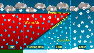
For us the questions are how much snow, how much sleet, any freezing rain? and how much rain?

It looks like we’ll should have frozen something on the front end and back end.  But, what about the middle?  Changeover to rain? and for how long and how much QPF goes to that?

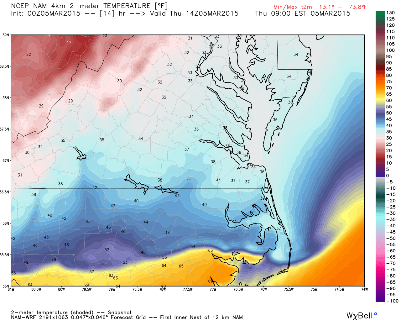
Most likely outcome for the Triangle at this point seems to be some frozen at the onset, with changeover to rain for a good portion of the storm, followed by snow at the end.  Indications 4 days out are that we should expect a rather sharp gradient in the haves and have nots.  That is, over a relatively short distance, snow totals should ramp up.  For example, see this projection. (and not to be one of those proliferating NWP snowfall maps…this is to show the gradient)

Screen Shot 2016-01-19 at 12.25.01 AM

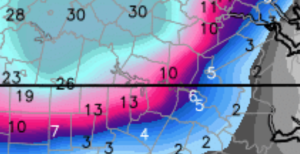
You see how quickly we go from 3″ at RDU to 13″ at Roxboro to 30″ in Central VA.  Again, don’t take this as literal.  Just one piece of guidance for real life humans to interpret and come up with their best assessment.

Bottom line, we don’t know yet.  And I imagine we’ll be fine tuning this up to Thursday night.  There will be significant wintry precip in NC.  The mountains are a near lock…east of there we’ll see how it works.

In the meantime, we can expect a round of flurries or a lucky snow shower on Wednesday evening.  The QPF (amount of actual water equivalent) will be very small, but anything that falls should have no trouble sticking around with the antecedent cold temps.  We will monitor it assiduously, as a little snow goes a long way on frozen ground to make for bad driving a la Jan 19th 2005…lo these 10 years ago.


End of Week Storm

Hope everyone enjoyed their cometic snow event this morning!

I thought I’d follow up on my earlier alert for end of this week, especially since the snow hype machine will begin in full force after the last couple runs of the Euro (and to be fair the GFS, too)

Yes, it seems a pretty good bet there will be a significant East Coast winter storm into the weekend.  But the range of outcomes with regard to sensible weather and it’s impact literally run the spectrum.  At this point, we need to be alert for the possibility a strong storm with significant wintry consequences over a good portion of the East Coast from NC north thru New England.  There’s a lot that could go wrong…so, let’s wait and watch.

Snow-Sleet-Freezing-Rain

Right now, it looks like NC would be on the southern end of the action with a mixed bag in the Triangle.  It’s a classic setup with more proportion of snow north and west with the mountains the big winners.  Interesting to note that the timeline has been trending faster by the numerical guidance, which helps from a cold-air-in-place-perspective.  Not in our favor, is the low origin, which would traverse the Tennessee Valley.  A more favorable setup for central NC would have the low farther south.

There no doubt the Euro is the model with the best skill in these situations, but it doesn’t mean it’s right on day 5 or 6, just that it’s the best of what we have.  Should be fun to see what sort of corroboration exists for the major storm in the operational run when the ensembles come out in a couple hours.

Again, plenty of time to dissect this over the next couple days.  Don’t run to the grocery yet!


sNOw News Is Bad News

Happy New Year!

Curiously, there seems to be quite a buzz about the potential for 14 flakes of snow this weekend.  And with the buzz come many questions directed my way.  So, I thought I’d take a second to clarify that if I am not excited about the possibility of something wintry (or otherwise meteorologically spectacular), then I probably won’t post.  That is…if something is going to be a non-event (like the flurries before Christmas), there is really no need to update.  So, going forward, consider no news as bad news for the snow lovers out there.  And if you want more frequent thoughts from me on the weather you can follow me on twitter @trextrex14.  I tend to tweet with short updates especially when an extended post is not warranted.

All this being said, this weekend looks quite unimpressive.  The cold will follow Monday and beyond, and the cold will be significant.  But more intriguing is a system pegged for late next week into weekend.  Let’s watch that to see if we lovers of the white flake from above will be more than satiated!


‘Siri’ously!

This evening’s post was my first attempt at posting via mobile.  So I used Siri to lessen the typing.  And then I didn’t have time to proof.  I’ve corrected the post now, but there were some funny things!  Ha!

How’s this for a front! (valid tomorrow AM)

hires_t2m_norfolk_15The latest American models continue a wintry threat, if even a bit less bullish.  But there’s really not an appreciably significant difference.  Tomorrow, as the time horizon of interest comes into range of the  high-res short-term models, we will evaluate along with radar trends to see how many problems we’ll have.

HOUSEKEEPING ISSUES…some of you have voiced concern that you have not been receiving emails when I update the site.  I’m not sure what’s wrong, but will look into it.  In the meantime just check back to the top page (don’t use a link from an old email because it will mostly likely take you to a specific post).  Navigate to weathertrex.com directly and you will always get the latest post.