« Posts under SNOW

For Raleigh, Things Seem on Plan

The northern part of the Triangle got some bonus snow on the front end this evening with only 27 flakes in Raleigh…or was it 28?

So the idea that the steady (light to moderate) snow moves back in early morning before sunrise still holds. And at that point begins the game of nowcasting banding structure and figuring out who wins for the initial snow/sleet accumulation.  Right now indications are that the enhanced axis probably lies north of Raleigh.  But we’ll see…that’s why you play the game, right?

More tomorrow and for more frequent updates, follow me on Twitter @trextrex14

Winter Weather Nuisance

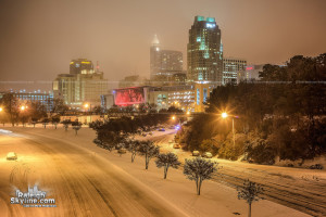
For the Triangle, we will dodge another winter weather bullet.  Unfortunately for the snow geese, it is unlikely that Raleigh looks anything like this tomorrow…

raleigh_snow_ice_abandon_cars_feb_12_2014_raleighskyline.com_05

While we will end up with a wintry mess for tomorrow morning’s commute, the impacts in the Triangle should be limited to some minor snow/sleet accumulations followed by minor ice accrual owing to warming aloft.  Surface temperatures should be able to rise just above freezing by mid-afternoon to bring the party to an end.

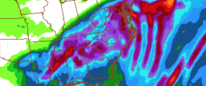
North and west, surface temps will hold under freezing for longer, allowing slightly more significant accumulations of both snow/sleet and freezing rain.  South and east there will be little to no accumulations of either.  The quicker the precip arrives, the more likely we are to achieve snow/sleet accumulations and a delayed onset would mean something like only a dusting.

Right now the best estimate for how this plays in Raleigh is for the steady light snow to begin between 3:30-4:30am (there could be flurries this evening, though).  The snow relatively quickly mixes with and changes to sleet toward daybreak.  Then, through the morning the sleet mixes with and changes to freezing rain until the temperature creeps up to freezing just after lunch.  Best guess for our accumulation is 1/2 to 1″ of snow/sleet with a 1/10th of an inch of ice accrual from the freezing rain.

So while tomorrow, especially in the morning, will be a winter potpourri, the accumulations should be relatively light and short-lived.  Temps will continue to rise overnight Monday into the 40s and rocket into the upper 50s with heavy rain on Tuesday.

What’s the forecast bust potential??

downside risk- the precip overnight and into tomorrow AM aligns itself along an axis farther north near the VA border, leaving Raleigh with only a couple hundredths of liquid equivalent from a couple of snow/sleet showers and a quick bout of freezing rain.  In this scenario…little to no sensible impact.

upside risk- 1) the steady precip arrives a bit ahead of schedule and is slightly stronger and more banded over the Triangle, 2) the cold air damming is more pronounce and more stubborn to erode than the models depict.  In these cases, 1) would give Raleigh the chance for up to 1.5″ of snow/sleet and 2) would extend the period of freezing rain so that the glaze could reach .15 of an inch.  Any way you look at it, even the upside risk is not a particularly significant storm.  Even if number like those were achieved, the warm air at all levels will eventually win out Monday evening and the Monday night and Tuesday’s heavy rain will was it all away.

I’ll be watching the latest trends and update this evening.  And remember, don’t freak out when you see a snow flurry this evening.  The real stuff won’t arrive until overnight.


Winter Storm Potential Discussion this Afternoon

Central NC will experience a round of wintry weather late tonight thru midday Monday before temps rise above freezing and we have heavy rain Mon night into Tues.  There seems there will be enough precip to cause problems before the changeover.  I’ll give a full discussion and update late this afternoon.

The Trend Ain’t Your Friend…

…not this evening.  Numerical guidance tonight seems to be poo-pooing any accumulation in Raleigh.  Really, I can’t see much of any reason to expect any more than a flurry here and there this far west.  Precisely the reason I haven’t mentined this possibility over the last week.  Anything of consequence is simply unlikely to happen.09Maybe we could get lucky, but even the ‘lucky’ upside potential is only an inch or so. Hope you did your homework!

Precip on Monday will be the bigger story.  Let’s see how that evolves. At this point, it’s hard to get excited about a lasting wintry event.  More likely is frozen on the front end that all to soon changes to rain.  So many details to figure out…all dependent on the low track.

Lots of time to clarify all the details.


Winter Is Coming…

…to which some of you are probably saying, “What are you talking about?!  Winter is here!  It’s cold!” Which it is, yes.  But an even colder weekend lies ahead with two chances for wintry precip flanking it on either side.  Your Valentine may have good reason to be “cold hearted” this time around!

Jon-jon-snow-34156123-1920-1080_zps00afaa56

About tomorrow…  Upper level energy will spawn a relatively weak surface low off the SC coast tomorrow AM.  The resultant confluent moisture and lift now looks to be sufficient to generate an area of snow over eastern NC.  The available moisture gradient increases as you go east.  It’s difficult to exactly pin down what the QPF field will look like, but the short term models are beginning to indicate that the axis of greatest precip will orient itself generally west to east or wsw to ene…again with the heaviest totals on the eastern side of that band.  While the models have trended generally ‘wetter’, this still looks to be a generally light event, especially this far west in the Triangle.  I can say with confidence that most from the Triangle east will see some snow, but it’s difficult to pinpoint what will happen in your backyard until we see where the aforementioned axis sets up.  In this axis is probably 1″ in the west to 2″ in the east.  As you go farther east warm temperatures being to play a role in the precip falling as all snow.  Back west toward Raleigh, it should be mostly snow, altho you could rule out a little sleet.

Bottom line…flurries and snow showers begin tomorrow around daybreak and increase in intensity thru lunch.  With the cold of recent days, the snow that falls shouldn’t have much of a problem sticking to the ground and untreated roads.  Look for a dusting to a half inch for now with the potential for an inch if things setup right.

About the cold over the weekend… Brrr.  Saturday evening lows to should run in the low teens in town with maybe some single digits north.  High on Valentine’s Day probably not making it out of the 20s.

All this cold sets the stage for a southern track low to arrive on Monday.  At this point, I’m sorry to disappoint, but it’s doesn’t look to be the classic snow setup.  It looks to be a snow to sleet to freezing rain to rain mess.  Lots of time to work that out.  But be prepared for a what could be a high impact event.


Tough Call for Sunday Snow

We’ve known for several days that there would be a rapidly deepening low forming this weekend off the Southeast coast that would race out to sea.  At this point, it looks like the low will be tracking ‘too close for comfort’.  As is the case with, particularly bombogenesis, the models many times have a tough time converging to a consensus solution…even still with just hours until the event.  And so this is the case today where much uncertainty and spread exists among the numerical guidance.

Two factors to consider… 1) Low track and it’s implication for where the tight precip gradient lies and 2) thermal structure of particularly the lowest 1000 or so feet of the atmosphere.

This is where much of the uncertainty is in this forecast.  Obviously a track closer to shore means more precip.  And this is one of those situations where the precipitation rates can dictate precip type.  Heavier precip rates will tend to cool the marginally cold boundary layer and mean that the precip falls as snow.  Otherwise, lighter rates would mean rain or a rain-snow mix.  Moreover, heavier precip rates would favor overcoming a somewhat warm ground for slushy accumulations.

Just for fun…here are the short term ensemble members numbers for total snow.  All over the place.

Screen Shot 2016-02-06 at 4.27.16 PM

I think it would take a miracle for everything to come together for something truly significant.  In Raleigh (and even less west towards Durham) the most likely outcome is a dusting to an inch accumulation, especially on grassy surfaces.  Looks like probably the highest accumulations occur toward the sandhills, maybe Goldsboro, where a couple inches are possible.  Timing is middle of the night thru tomorrow AM.  So for this one, the aesthetics of the snow falling will probably trump the impacts.  However, this is one to keep an eye on just in case.  We’ll see how it develops tonight and nowcast.

Upcoming…

There’s another chance for rain/snow mix on late Mon/Tues.

Then, a big cold shot coming for Valentine’s!  Temps could be 30° below normal.

And more interesting is a potential interaction with southern stream energy that may be lurking for early in the week following Valentine’s.

Next Round

The back edge of the steady precipitation shield is exiting the Triangle now.  There will be a lull for a bit before the next more showery, quasi-convective band makes it’s way thru this evening.  This band should be accompanied by moderate to heavy sleet/snow showers and even a rumble of thunder to two.  In fact, since it will be dark, you’ll probably be able to see the lightning go cloud to cloud.

So, expecte sleet and freezing rain in the lighter showers and when the precip rates pick up in the convective cells that’s when you’ll see a snow/sleet mix.  There could be another inch or so of accumulation, plus the potential for another tenth or so of glazing before things wind down later tonight.

Then tomorrow expect to see off and on flurries with the potential for a dusting to an inch or so more snow.

Enjoy the winter wonderland!  The glazing of the trees is really beautiful (until it crashes on your house, of course!)

The ‘I’ce Have It

Looks like Raleigh has taken another perfectly good snow opportunity and thrown it down the tubes for an ice storm.  I feel like Lucy has just ripped the football out from us again.lucy2

Oh well, it is what it is. At least the ground is white and pretty.  We have missed the window for real snow and are now into the sleet freezing rain window.  Expect more of the same…sleet showers, mixed sleet and  freezing rain. Then later in the afternoon we’re likely to have mostly freezing rain predominate.  It will be showery…off and on, and some could be of moderate intensity.  Surface temps are running in the upper 20s, which should make for efficient ice accrual.  Still expect temps in Raleigh to edge up right to the freezing point at which time ice accrual becomes less efficient.  Still, watch out this afternoon as things begin to glisten and ultimately topple over.  1/3″ of ice looks pretty easy to achieve, maybe 1/2″.  More later on…

Steady as She Snows…

…and Ices!9e3d1b35ac45742cf5745c992b30699b.620x388x1

I’m happy to make this short and sweet this evening.  While we have this latest model, and that latest model…the guidance balances out to warrant holding steady with my current thinking.  With that said, it’s worth reiterating that the gradient of snow (and sleet) totals will be steep.  Knowing where the transition zone sets up will drive how the totals map ends up being draw.  Unfortunately, the state (limitation) of the science today is that we cannot honestly make those sorts of quantitative pronouncements.  We can, however, qualitatively say what the accumulation distribution will look like and refine the transition zone in a nowcasting mode.

To boil it down…my forecast for Raleigh of 3-5″ snow/sleet plus 1/4-1/3″ ice glaze plus 1″on Sat is good.  Can I see downside risks?  yes!  Can I see upside risks? yes!  Has tonight’s numerical guidance provided a clear direction?  no!  So let’s see how things evolve tomorrow AM.  They key will be how long we stay snow and/or how much sleet mixes in.  If we’ve begun mixing sleet by 10, then the lower end totals will rule.  If we keep predominantly snow thru after lunch, watch out.

Finally, to reiterate…for simplicity I’ve made just a Raleigh forecast.  You can extrapolate to other locations with the simple rule of thumb of… more accumulation north and west… less accumulation and more ice potential south and west (use the coastline as the angle for the line orientation)… moreover, there is more risk to change over to rain south and east.  


Major Winter Storm Imminent

As complicated a forecast as this is for central NC, I’m thankful to not have to worry so much about the battle raging over the northern extent of the major snow axis in the Megalopolis!

At midday, I’m comfortable with the previously outlined ideas for precip types and timelines.  In yesterday’s post we talked about how inches of frozen stuff on the ground would vary wildly over relatively short distances owing to duration of each precip type.  So the forecast that I’m going to outline now will be for Raleigh.  Then we can hand wave later for other locations.

Here’s what I think happens…Precip arrives tomorrow 4-5AM in the form of snow.  We should be able to achieve 3-5″ of mostly snow and sleet before early afternoon. Then it sleets for a bit before changing over to freezing rain. The tricky part is figuring out how much freezing rain accrues.  Complicating factors that will limit high totals will be the anticipated heavy precip rates and surface temperatures close to freezing (i.e. not in the upper 20s).  These things are in our favor as a limit.  Favoring greater accruals are indications that the warm nose might not be as pronounced, i.e. the temperature at 850mb (about a mile up) might not be as warm as first thought. This is the trickiest part…deciding how long we have sleet before the change to freezing rain.  My best guess is to say we add 1/4″ to 1/3″ of glaze.  It is also possible that we briefly pop above freezing for an hour or so late evening tomorrow. (remember that freezing rain is a self-limiting process, which actually releases heat into the atmosphere. so each time a rain drop freezes, the air get slightly warmer.  if you don’t replace that ‘warm’ air with more cold it eventually heats up)  So, if we’re dumping a lot of rain and freezing a lot of rain we’ll probably warm to at or just above freezing before the colder air sweeps back in behind the storm.  Once the main precip shield exits tomorrow evening we will be dry slotted for several hours and wait for the elusive wraparound snow.  I’ll go conservative on that for now with an additional of snow Sat, but some folks could easily get up to 3″ if it really works out.

Let me summarize succinctly… For Raleigh, precip begins just before dawn with 3-5″ of snow/sleet before an afternoon changeover to freezing rain, which adds 1/4 to 1/3″ of ice, followed by a lull until Sat AM for another inch or so.

There is definite potential for more upside on the “white stuff on the ground”, but also a definite downside risk as well in the case that freezing rain to predominates.

Also remember that there will be impressive cyclogenesis taking place on the Carolina’s coast and as such, winds will begin to pick up.  So expect gusty winds in combination with trees and power lines coming down from the weight of the ice.  Make sure to you have batteries and candles.  And make sure to charge your mobile phones!

Screen Shot 2016-01-21 at 1.59.00 PM

Storm total QPF (predicted liquid equivalent)