« Posts by trex

Steady, Steady…

As much as everyone wants to hear the latest… the latest is that what I outlined yesterday still looks good to me tonight.

I can see concerns for bust potential above and below my current forecast.  My thoughts on Wake Co. follow, but really they are applicable to the wider region…

  • bust big?… there will be a period of heavy snow after the initial onset of precip which quickly cycles thru rain to sleet to snow.  some models say there could be as much as 6-8″ in that initial hit.  so, you’d have that and then sleet and then frz rain.
  • bust small?… fears of the warm tongue penetrating earlier and more pronounced would limit the initial accumulation of snow and changeover precip to sleet and freezing rain much more quickly.

I’m going in the middle on this and holding firm to my forecast from yesterday.  The action starts overnight with snow beginning in earnest between 2 and 3am.  I’ll nowcast early morning with an update for how that tricky transition zone looks.


Wild Ride Coming!

It’s been many, many years since NC has experienced a winter snow of this magnitude this early in December.  This storm promises to make it a December to remember.

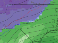
As has been widely advertised, there are going to be heavy snows to the west, rain to the south and east and a battle zone that should line up fairly close to a line from Raleigh to Charlotte where the forecast is super complicated and the weather super messy. I can hear the bemoaning of the infamous “line” as I type.  There are some interesting numerical modeling disagreements ongoing behind the scenes that hopefully will be resolved soon, but in the larger picture here are a couple of key points:

  • There will be a lot of moisture available for this system.  Liquid equivalents will run about 2″ for most along and south of the Triangle and Triad with amounts tapering to an inch along the Virginia border.
  • Heavy snows of 12 to 20″ will be common in places like Greensboro, Hickory, Boone, Asheville where most of the moisture comes in the form of snow with little mixing.
  • The zone to the south and east, in places like Burlington, Chapel Hill, Salisbury and Concord, should probably expected half snow, half sleet and a little freezing rain.
  • The next zone to the south and east has Durham and Raleigh and Charlotte.  I expect a mixed bag of it all…something like 3-6″, 1-2″ of sleet and 1/4 of freezing rain.  Remember that west and north in these zones you are more likely to skew to snow.  For instance, Durham may get 6″, Raleigh may only get 3 or 4″.
  • Remember that whatever snow you get will be compacted by any sleet falling on top of it.  So, you could measure 6″ pre-sleet and shrivel down to only 3″ afterwards.
  • IMPORTANT: The impacts of this event will be high and widespread no matter what form the frozen stuff on the ground is.  And after you get a couple inches, it’s really all the same in terms of impacts.  It just takes longer to go away with more of it there when it’s over.
  • Something to watch will be the extent of the freezing rain.  If the warm nose penetrates farther north and west and deeper than is currently thought, significant ice accrual could become a real problem.
  • Timing:  this looks to arrive from south to north overnight tomorrow.  For Raleigh, perhaps in the 1-3am timeframe.

As always, stay tuned as we monitor the latest trends and I will update as necessary.


Major Winter Storm Impending

Details need to be ironed out, but what it clear is that an early season winter storm is on tap for much of NC this weekend.

I don’t want to get into specifics this early… we have plenty of time for backyard forecasting later.  At this point, let’s say that from Wake Co. N and W this will be a high impact event with significant snow, sleet and freezing rain beginning at late night Sat into Sun and continuing thru Mon.  Especially from Greensboro west, the snow totals will be historic for this early in the season.

Of course, we still have three days to go, but as it is now… the model guidance is converging on a storm to remember.  Start making alternate plans for Sun, Mon and Tues of next week.


Early Season Major Winter Storm Coming (but where?)

A quick post to say, yes… there is the potential for a major winter storm in many parts of NC, VA and upstate SC this weekend.

Of course, all that potential doesn’t mean anything unless it’s in your back yard.  It’s waaaaay too early to say anything definite.  Be alert for the possibility of significant issues, especially north and west of Raleigh.  At this point, we can say that there is the potential for higher precip totals (liquid, frozen or refrozen).

We will monitor the evolution of this system for impacts Saturday night thru Monday. This will be a fun week of forecasting!

‘Wind’ow of Time for Damaging Gusts

The main rain shield from Michael is just arriving in Raleigh.  The heaviest axis of rain looks to setup west of the Triangle where several inches are likely while totals near Raleigh are likely to be more on the order of 2″.

Our main threat appears to be from a period gusty winds in the 5:30-7:30pm timeframe after most of the rain has passed.  On the back side of the circulation will be a burst of winds that could catch everyone off guard, thinking the storm has passed.  The higher resolution models indicate that higher momentum air above the surface should get mixed down to near the surface making for a short period of of straight-line winds similar to a derecho event.  10m winds are indicated in the 60-80mph range.  If this pans out, we can expect lots of trees down following the soaking rains, plus associated power outages.

Again, this looks to move from west to east thru the Triangle just after commute time.  Stay alert.

Michael, Row Your Boat Ashore…

Michael is gaining strength offshore of the Yucatan Peninsula tonight.  If not for stiff westerly wind sheer, Michael would have the potential to strengthen rapidly.  As it appears now, Michael should have to deal with significant wind shear throughout its evolution.  Hopefully, that will limit its intensity.  There is uncertainty to the extent of that influence.  So, while I would expect Michael to be a borderline 2/3 storm at landfall…it’s certainty possible for it only to be a minimal hurricane or, as some outlier models suggest, a cat 4.  I’ll remind you that track forecast has much higher skill than intensity forecasts.

So what does it matter for NC?

Landfall should be along the Florida panhandle.  Then, the track is likely to be just inland from the coast all the way up through SC and NC before exiting the Outer Banks.  Again, the exact location of the center of Michael isn’t so important except that a cat 3 moving inland fast (even as far south as Florida) will dictate where the gustiest of winds will be.

And speaking of fast-moving… it looks like this may be a saving grace with Michael.  Still, we’ll expect gusty, perhaps damaging, winds in eastern NC along with 3-5″ of unwelcome rain.

Lots of time to figure it all out before impacts in the Thursday timeframe.  Of course, there’s still some discrepancy in the thinking on that as well.  Stay tuned.

Go with the Flo

The first real heavy rain band is arriving in the Triangle.  Remember that you can generally expect the highest wind gust to accompany the heavier showers and thunderstorms because the higher momentum air 1000 ft above the ground tends to get entrained down to the surface.

So, over the next couple hours watch for flash flooding, higher wind gusts and the possibility of an isolated small tornado.  In fact, right now there is a radar indicated mesocyclone and possible tornado racing west from Rocky Mount.  It’s holding together nicely, currently, near Bunn. If this continues, it would arrive in the Wake Forest Rolesville vicinity close to 2pm.


Breaking It Down

My last post was a synopsis of the highlights of the latest numerical modeling.  This time I’d like to make things as simple as I can with a series of bullet points.

This evening, we have confidence that the track of Florence will take her toward the NC/SC border over the next couple days.  (I’ve been advocating a landfall near the NC/SC border for a while now.)  The latest guidance questions if an actual landfall will occur… meaning, the eye may stall 25 miles offshore and meander with a lack steering forces for a prolonged period.

First and foremost, this situation is significantly more complicated than an average tropical cyclone landfall, because steering currents for Florence will be weak once she is under the influence of the departing Atlantic ridge of high pressure.

Let’s break this down step by step for Major Hurricane Florence…

  • the intensity should wobble between Cat 4/5 dependent upon eye-replacement cycles
  • the trajectory should take it to the NC/SC border
  • the forward speed should slow and perhaps even stall Florence offshore
  • where a stall might occur will be key as to the extent of wind damage for the coast… a stall offshore will allow Florence to throw wind and rain to the coast and coastal plain (albeit in an eroded state from the Cat 4 status) for 24+ hrs
  • if the stall occurs inland, Florence will be robbed of her energy source and will spin down quickly, with only torrential rains to deal with

At this point, the model guidance indicates that the slowing forward speed will make it so that Florence won’t be able to penetrate far enough inland for significant wind gusts towards Raleigh.  The uncertainty of the areal coverage of what will be a prolonged heavy rain event is the wild card.

For tonight, confidence is increasing that the threat of damaging winds should be well to the south of the Triangle, in the southern, central and eastern NC.  Flooding rains seem likely to extend northward toward Virginia, however, predicting where those heavy axes will line up at this point is premature.

My big point tonight is that there is a significantly higher degree of uncertainty with Florence than there would be if we had a storm under the influence of defined steering currents.  Continue to stay alert and be ready for a much worse Triangle scenario.  We still have 2 days and 700 miles to go!

Mercy and a Mean Left Hook

We have some good news and some bad news.

The good news… In the battle of mercy armwrestling that’s been going on between the American (GFS) and the European models, the GFS has thrown in the towel and conceded the European’s track guidance of Florence approaching Cape Fear for landfall(?)

The bad news… This is the reason for the above question mark and where the left hook comes in.  The latest operational European run, hot off the presses, depicts the same track, that it has been remarkably consistent with, from the past couple days.  However, this run is a little slower in forward speed.  Consequently, Florence never quite makes it ashore before it loses steering currents.  Then it drifts southwestward paralleling the coast to SC.  So the track plot literally looks like a hard left turn as Florence gets to NC.  This would be horrible, because the hurricane would still have an energy source over water to fuel a prolonged period of winds and torrential rains that would be devastating along the coast.

So, while we’re more confident of the direction it’s coming with a track into the Cape Fear area, the next and probably really difficult thing to discern is what happens when the steering currents are gone and just when does that happen.  The above scenario outlined by today’s Euro is just one possibility that we need to consider over the next two days before Florence arrives.

It’s important not to get fixed on an exact solution yet.  We know that this is going to be a devastating situation for some in the NC/SC/VA, and a widespread bad situation for many.  Everyone in central and eastern NC and upstate SC should stay alert and prepared for the possibility that you could be one of the ones devastated by life-threatening conditions, as opposed to inconvenienced by a bad situation.

I’m still hoping to have more firm ideas on the track by this time tomorrow.


Quick Update Now…More Comprehensive Post Tomorrow ~3pm

There’s not a lot to add to what I posted last night.  The same general thinking applies although, there may be a tendency to shift landfall farther north.

Today, the rapid intensification expected to take place has occurred.  Currently, an eye wall replacement cycle is underway.  It is likely that once this is complete, we will have a Cat-5 Florence heading for NC.

Tomorrow, we can narrow the track cone a bit.  Tonight, things look farther north.  Tomorrow they may look farther south.  But by Wed AM we should be confident in a detailed track.  And as a reminder, that track will dictate the extent of the worst inland wind damage, which will be something like 25 miles west and 50 miles east of center of circulation.  But as bad as all the winds may be, the real widespread threat should rain and tens of inches of it.

More tomorrow…