« Posts under SNOW

(next) Wednesday’s Winter Weather Waggery?

Wow…more Ws than a CSI investigation!

Long time, no blog.

Not that we should get hyped up about a potential day-8 event, but this winter that’s about the extent of what we have to cling to.  I’ve been bored with the winter weather drought and fed up with the 30-something rains…so let the snow mongering begin!

Before we get to the hypotheticals of 7-8 days out, let me affirm the significance of the cold air on the way for this weekend.  It will be impressive.  Lows in the low teens, and highs on Sunday (despite a lot of sun) in the mid 20s.

2048px-Lorenz_attractor_yb.svg

Then as the pattern relaxes a bit after that, how quickly will a southern stream disturbance arrive in NC where the cold resides?  Long range modeling has been

hinting at a confluence of the two for a couple of days.  Over the past couple of model run cycles there seems to be more agreement that a storm with a southerly track will affect the SE by mid-week.  How the low tracks is up for grabs…and as you know, you’ll want to be on the northern side of the track to receive wintry precip.

That’s enough for now.  Just be alert the possibility.

And…I’ll tease you with a new game that I’ll introduce in tomorrow’s post. 😉


It’s All Over But the Cryin’

First off, the apology…as advertised from the beginning, the question for this event was to be the precip.  As it turns out, the much bemoaned and berated GFS will win the battle of the small QPF reality.  The primary area of precip is heading off to the northeast toward Norfolk now.  As expected, the max ice accruals will be just north/east of Raleigh.  However the totals across the board will be less than half of what was expected.

Of course, this is all good news from a safety and disruption standpoint…but not so good from a ‘i changed my plans’ perspective.  Again, apologies for my being fooled on this one.

So for the remainder of tonight…the major precip is done.  There will continue to be showers of freezing rain, freezing drizzle and perhaps even some sleet later on as more cold air works in the column.  These showers should prove to be little or no consequence.  So most places near Raleigh should end up with a glaze to a tenth of ice at most.

Looking forward…we’ll have a warm up over the next week before turning back cold end of next week into the last week of Jan.


How Do You Like Your Ice?

…shaved, crushed, cubes?

Everything looks more or less on track.  However, I’m puzzled as to why we’re calling off after school activities today, but I suppose somebody get’s big bucks to make that decision.  As to timing of onset, things in Raleigh shouldn’t begin in earnest until after 10 this evening. There will continue to be a couple of passing showers and areas of drizzle, though. The main precip shield hasn’t even developed yet.  When it does, nowcasting it’s arrival should be much easier.  Then overnight the majority of the precip will fall in the form of freezing rain with some sleet mixing in, especially north.

Icy-Tree1-533x222

And I’m thinking to maybe dial back the ‘sweet spot’ totals I mentioned to up to .4″ with the next band of counties to the west to up to .25″.  These aren’t really material changes in terms of impacts, but I wanted to dial the totals to reflect what’s more likely, rather than what is possible.  Again, once the precip shield develops this evening we should be able to get a good handle on it, as opposed to believing a bunch of 0s and 1s some oversized calculator is crunching.


Significant Icing More Likely

Quick update…

Overnight models have trended wetter with the GFS finally on board.  The new 12 NAM is in and continues bullish for significant event.

Particularly Raleigh and north and east should see the most problems.  Heading towards Durham and west they should have less icing.  The axis of heaviest moisture will be along the I-95 corridor and east.  So there will be the sweet spot of heaviest ice accumulations that balances the cold to the west and moisture to the east.  This looks most likely to be in Wayne, Wilson, Nash and Halifax counties where ice accumulations will be up to .5″.  Then the line of counties the west of that…Harnett, Johnston, Wake, Franklin Warren, Vance should see accumulation up to .3″. Then west of there, up to .1″.

Ice-Storm

Remember that .25″ is a good guideline for when an ice storm becomes bad in terms of downed trees and limbs and widespread power outages.  Further exacerbating this event will be the fact that the ground is very wet from a lot of rain yesterday and even this season.  So we may see more uprooted trees than normal with this storm.

You’ll see the NWS upgrade the winter storm watch to a warning this afternoon.  So, now is a good time to begin making alternate plans for tomorrow.  Also check to make sure you have extra batteries,etc…  Oh and don’t forget to buy lots of bread, milk and beer! 😉

More updates as more model data comes in.

And for more frequent, short updates, follow me on Twitter at trextrex14


Ice Event Wed Morning

It’s been a while since there’s been much to talk about in terms of wintry weather for Raleigh (aside from a quick blast of boo chilly air last week).  So today, in between monsoonal downpours, we are watching the potential for a significant icing event overnight Tuesday thru lunch on Wednesday.

ice tree

A fresh supply of cold air will begin arriving in NC as the rain exits later this evening.  So, the extent of low level cold air supply will not be in question.  The uncertainty will be in how much precip will fall in the Triangle, owing to a weak surface low riding up the coast.  The axis of heaviest precip will certainly lie to the east of Raleigh.  The extent to which it bulges back westward will be the question.

Models differ on this, ranging from just some drizzle and a hundredth or two of liquid equiv, to up to a 1/4″ of liquid equiv (QPF).  At this point, I would expect around a 1/10″ of ice accumulation, which will be enough to make for bad driving and a few problems, but not result in widespread power outages and/or bring lots of tree limbs down.  We’ll watch to see how the numerical guidance trends with QPF over the next day to get a better handle on if this will be just a nuisance event or something to make alternate plans for.

As to timing…It appears that we will be lucky that the freezing rain should begin late Tues evening (10pm to midnight) and continue overnight into Wed AM.  This should help with fewer travel problems, and let people evaluate the conditions Wed AM before venturing out.

More updates later.  But if you would like more frequent updates, follow me on twitter at:  trextrex14


Gizzard Blizzard?

Ok, no Thanksgiving blizzard for Raleigh, but maybe there will be some snow in NC on Wednesday with the potential for some hefty snow in the Mid-Atlantic and NorthEast to make for a ‘gizzard blizzard’!

There is mounting evidence to suggest the possibility of a wet snow event in central NC late Tuesday and Wednesday.  The cold will be marginal, but heavier precip rates might be able to overcome warm boundary layer temps.  Alternatively, we could have everyone’s favorite…a cold 35° rain.

Still a lot of uncertainty and variety of solutions to study.  At this point the euro ensembles give it a 1 in 3 shot of measurable snow.  The operational GFS has been bullish for the past couple runs, but it’s interesting to see that the beta version of the new GFS upgrade which has been performing well, isn’t biting…yet.


Winter Arrives Early

I figured I should turn the snow showers on for the webpage…

Happy start to winter!  Don’t worry what the calendar says.  Next week a monster arctic high (especially for Nov) invades the US with A LOT of cold air.  Cold temps arrive here at the end of the week, and then could there be an over-running situation late Fri or Sat?!  something frozen?!

It’s a long way off and lots to debate over the next week, but what looks like a great bet is the cold!

Oh, and watch out for one more round of mod to heavy showers with maybe a clap of thunder before the night is out.

Yes, It Will Snow…

…but rain is the more likely p-type.

With boundary layer temperatures several degrees above freezing, it will take heavier bouts of precip to drive any mix with or change to snow.  And while the axis of heavier moisture looks confined east of I-95, it wouldn’t take much to back it into Raleigh as the coastal low develops off Hatteras.

So, I’ll stick with cold rain, sometimes mixed with snow, and probably even a shower where it’s all snow for a while…but not enough to accumulate on any roads…lucky to accumulate on elevated surfaces north of the Triangle.  All this with the caveat to that everything evolves with the deep moisture to the east.  We’ll monitor and see.

That’s for us.  But more exciting will be to watch this storm bomb out up the coast with hurricane forces winds on Cape Cod.

Bullet Dodged?

As to the question of “To Sea or Not to Sea?”… I think we still have to wait and “see”.  No doubt, the majority of the modeling indicates that the eventual explosive cyclogenesis should take place offshore far enough preclude an I-95 corridor blizzard.  However, there are some things that just don’t seem right to me.

Anytime we have coastal cyclogenesis the uncertainty level is heightened.  In this case, multiple different shortwaves will interact and incite two surface lows off the East Coast.  The various models differ on where each of these lows form and how they track north.  What is unifying in the solutions is that one low cannibalizes the other as it bombs out heading for Nova Scotia.  In many of the simulations the more south and east low predominates and much of the energy is pulled east.  In the latest, Euro there’s even a Fujiwhara-like tango of the two low centers…dancing lows
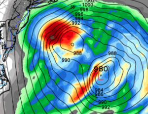
It seems weird to me that the more western low would lose out to the eastern low, especially since the western low should be fed by the warm Gulf Stream.  See the current SST (sea surface temperature) anomalies…

SST anomalies

By now you’re probably bored and want me to cut to the chase as to what this means for NC, so I’ll oblige… I don’t know.  Just picking.  Kind of…

For clarification of time…this will be Tues AM.  Following the party line would be to say that development of a coastal low will confine the deepest moisture and precip totals east of Raleigh.  And without sufficient precip, it will be tough to cool the boundary layer to near freezing.  That means that there should be a cold rain mixed with snow, especially in relatively heavier showers of precip.  But we’re only talking .1″ of liquid equivalent, so not much of anything.  Heavier precip amounts will be found farther east to the coast.  In the northeast part of NC into eastern VA is where there could be more snow mixed in.

All this is based on the low developing sufficiently offshore, a westward jaunt of 100 miles would mean heavier precip rates and more heavy wet snow into Raleigh.  Perhaps I’m being foolish about this, but I want to see more agreement in the modeling before I pronounce this scenario off the table.

If you’re traveling north this week.  Boston and Cape Cod look to get clocked.  Again I want to see how this dueling low thing plays out and which dominates, but under the western-dominant low idea we would see lots of snow back into Long Island and double digit totals even into NYC with several inches back to Philly and tapering back south and west.

Lots of time yet to fret!

To Sea or Not to Sea…

…that is the question.

Like I said yesterday, we’re in that mid-game time when a track out to sea comes into play.  Certainly the 12Z runs of pretty much all of the models have shifted east.  The other trend this go round has been to rapidly deepen the low (bomb it out) as it races north, which is also something we were looking for.

There is good consensus on the potential for a very powerful Nor’easter with pressures nearing 960mb (that’s low…’Superstorm Sandy made landfall in Jersey with a pressure of 946mb).  Of course, this will happen when it bombs out off the New England coast.  The question is, what does the track look like.  And we won’t really be able to say with any confidence until the energy (that thousands of miles away and will eventually grow to be the storm) is sampled by upper air observations on Saturday.  Once those observations are integrated into the models, then things will become more clear.

For you snow lovers, don’t take this as the kiss of death, because it certainly is not. And, in fact, this AM’s GFS still depicted several inches of snow for central and eastern NC.

Bottom line is that tonight’s models won’t interest me as much as those beginning tomorrow AM, but especially into Sunday.