…if you get a little rain in the next hour before the heavier snow showers arrive.
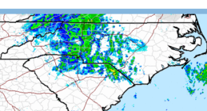
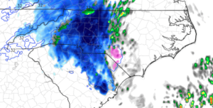
Short term high resolution models are doing a good job depicting today’s snow. Compare these:
Careful, because the color schemes are different, but at the top are the actual reflectivities (normal color bar from a typical radar shot) and at the bottom the simulated reflectivities from a short term ‘nowcasting’ model (the precip types are color coded snow=blue, pink=sleet, green=rain)
All to say that, I’m believing in a little higher totals at this point. Again, still the highest totals to the north and west, but the Triangle may be able to get 2-3″ generally with lollipops of 4 and 5″ under convective cells. And several reports of thundersnow have come in from the western part of the state. Not out of the question here for us, either.
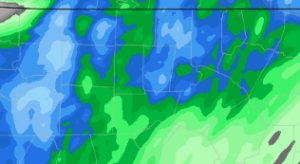
This next picture is of liquid equivalent QPF from that short term model on a super close-up shot centered on the Triangle (look for the county lines). Couple of things to note: the cellular nature of the precip distribution, and decent totals. Here the dark green starts the .3″ contour and the dark blue is .4″, while the second blue contour is .5″ and then each contour goes up by tenths. Bottom line is that this model depicts quite a bite of moisture.

(also, note that if you need these images larger, you should be able to click on them to pop them out of your browser window)
Here we go!


1:01 PM, February 13, 2014Tia Lawson /
Heavy snow in North Raleigh
1:05 PM, February 13, 2014Sherry /
Snow happy