« Archives in January, 2022

Generally Light Snow Overnight Fri/Sat

The situation is coming into better focus to suggest that the entire state will see a dusting to 1.5″ of wet snow. Additionally, separate mechanisms will be at play to provide the potential for more in certain areas:

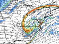
1) in the northeastern part of the state where the surface low begins to bomb out and throw back moisture as it rips up the Eastern Seaboard there could be another couple to several inches on top.

2) as the upper-level low swings thru in the wee hours of Friday night, there will be short-lived bands of moderate to potential heavy snow across central NC (akin to that of summer garden-variety thundershowers). In these favored areas, there could be another inch or two, and you could even see a flash of lightening and hear a clap of thunder. This is favored generally west of the Triangle, but not out of the question for Raleigh.

To sum it up… look for light accumulations of snow after midnight tomorrow. Expect ±1″. Be thrilled with anything more!

If you really want a blizzard, book your flight to Providence, RI for 2+ ft!

Chaos Reigns Supreme

Nearly 30 years ago, we all laughed at Jeff Goldblum’s (Ian Malcolm) seductive example of chaos theory to entice Laura Dern (Dr. Sattler). There’s actually some truth to this come-on act.

For the past couple runs, all the numerical guidance has been whipping back and forth. Sometimes the solutions converge more readily than others. In this situation, there are several nuances that will ultimately determine if Boston gets 24″ or 2″… similarly, for NC (not 24 vs 2, but several vs. flurries)

There is no need to try to make any updated projections at this point. Hopefully, things will calm down in tomorrow’s runs as the upper-level wave becomes fully sampled into the model initializations.

Sorry for no real answers at this point. The short guess at this point is a general swath of 1/2″— lucky 2″ across the entire state. Beyond that, there is definitely the potential for more, especially in the NE part of the NC.

Weekend Snow Hat Trick?

Since the last flakes fell last weekend, I’ve been incredibly good to resist the temptation to hype the potential for a third in-a-row weekend winter storm. There has existed decent potential for a major East Coast storm all week, however, the locales of emphasis have been centered from the Mid-Atlantic to New England. This is all still the case. However, over the past day or so, the numerical guidance suggests the storm could get it’s act together farther south, and with a track sufficiently close to the coast to provide snow to eastern NC before dumping impressive snows farther north.

The set up for storms like this always rely on the phasing of waves in the northern and southern jet streams. It’s tricky… is the southern behind the northern, both lining up in phase, or does the southern branch run ahead? Three days out, we’re left to try to analyze how well the models initialized from the observations (i.e. garbage in = garbage out), and make a reasonable case as to why one model solution is preferred over another.

Bottom line for tonight is that the trends in the last several cycles favor solutions that give, especially eastern NC, good chances for accumulating snow. This far out, there’s no reason to be exciting for more than an inch or two with areas toward Elizabeth City and Norfolk that have the greatest potential for significantly more accumulation.

So, that’s where we should be leveling our heads tonight. However, with the amount of potential energy on the table with this storm, you cannot discount the outlier solution (for now) that would give eastern NC an even more impressive snowfall than we saw last weekend. At the same time, hold in balance that the eastern outlier solution could play out with just a cold rain most all.

Let’s see how things evolve and the next couple days and hope for that NC Hat Trick!

The Snow is ‘Sticking’ to Plan

Quick update to confirm with all the curious snow lovers begging me for the latest… the storm is playing out according to plan.

Light snow has laid down about 1/3″ here at the world HQ of WeatherTrex.com. Snow is now moderate here in Raleigh, ITB. We should expect snow rates to ramp up over the next hour, such that after 9pm we should be accumulating at a moderate pace.

The wheelhouse for moderate to occasionally heavy snow in Wake county looks to be from 9pm to midnight/1am. Around midnight/1am, expect snow to tapper back down and all the fun is done around 3am.

I have no reason to change my thinking of 3-4″ in Raleigh. Look for totals that could scale up to 5-7″ as you head east to JoCo and over to Wilson where it’s all snow too.

Be mindful of lots of black ice for the next couple of mornings. Limit morning travel as much as possible.

Enjoy the snow!

Waffling…

When I said last night, let’s wait and see if those short term American models swing back… Well, they have.

Since we’ve been inside the short-term modeling window, the RGEM (Canada’s mesoscale model) has been steady and consistent in depicting a general warm advection-driven overrunning event that is more widespread in coverage with lower spike totals.

I could go back and forth with the details of the model vacillations, but I’ll spare you the ennui and cut to the chase for a couple of points of emphasis:

  1. All the rain that fell today is in the process of freezing in place. This puts a layer of ice in place as the arctic airmass continues to move into NC.
  2. The graupel/sleet/snow that is falling tonight won’t be a lot to see, but will add a small layer of frozen ‘stuff’ to contend with.
  3. There will be a lull during the day tomorrow, even as temperatures struggle to reach freezing. The real round of snow looks to reach Wake Co. in the 5-7pm range with earlier times as you go east.
  4. The models have come back home to solutions that still favor an axis of heaviest snows similar to last night’s post. The change may be to lower northeast NC accumulations down from the 10″ range to more like 8″ tops. Again, the thinking shifts now to a more general swath of light to moderate snow for wider areal coverage of eastern NC (with significant sleet and freezing rain as you go towards southeast NC… ice storm potential).
  5. Everybody wants a total for their backyard. The best guess for Wake Co. at this point is 3-4″
  6. Saturday clears up, but it will be cold; perhaps only getting above freezing for an hour or so. There will be some melting; not a lot. The most efficient melting will be in areas that receive sun, of course. After sundown, things get treacherous quickly, and will stay that way until we go above freezing around noon on Sunday.

This is a tough one to nail down. In the meantime, enjoy the waffling with some great maple syrup!

Updates tomorrow.

And the Fun Begins!

The American models throw a damper on the party this evening.

At this point, they may be the outliers… in contrast, to the Canadian that came in on point for the storm as advertised. As of this writing, I’m not inclined to change any of my general scenario… yet.

Several days ago, we talked about the possibility for Raleigh to miss this as the storm could skew to the east. Maybe that can happen with this? We’ll wait for any pivots until all of tonight’s runs come in; but, more importantly, tomorrow’s midday runs of the 12Z suite. Those will show us know if this is a blip vs. a trend.

For now, let’s reiterate the axis of heaviest snow, with a tweak to pull the west-most point of Albemarle to change to Pittsboro. This becomes the west-most point of the favored axis, continuing on to Norfolk.

Anyway you look at it, Scotland Neck to Norfolk will have the highest totals, 5-10″ there. Then from Scotland Neck back to Pittsboro, totals should range from 3-6″.

Updates tomorrow!

NC Winter Storm on Track

A quick update to confirm that we’re still on track for a moderate to possibly heavy winter storm, particularly in eastern NC.

As the arctic front enters NC on Thursday, rain will begin to changeover to sleet and snow as the cold air invades into Thursday evening and overnight. The front will serve as a focusing mechanism for waves of low pressure to ride from SW to NE along the Southeast Coast.

There are still plenty of details to be ironed out, but 3 days out, the models are converging on a consensus for an axis of heaviest snow lining up from Albemarle to Raleigh to Norfolk. Immediately, southeast of this line there looks to be the axis of heavy sleet.

Behind the storm it will be very cold. We’ll be dealing with whatever falls on the ground for a while after the storm is long gone.

I’ll have a more complete analysis late tonight.

Watching One More Weekend Winter Weather Whirlwind…

As today’s storm winds down for us in NC, we can look back and say that it came and went pretty well according to plan.

Note: there is the possibility of a snow shower or two rotating thru Wake Co. near the upper level low in the 11pm to 1am timeframe this evening (Sun, 16 Jan). Nothing to worry about with respect to significant accumulation, just an opportunity to see more of the flakes that many wished they had gotten earlier in the day.

Looking ahead, we’ll have a relatively chilly week, but with moderating temps each day ahead of an Arctic front which arrives Thursday accompanied by rain showers. Then, the uncertainty begins as to the possibility of a coastal storm, which is now being alluded to in the long range models for next weekend.

The numeric guidance at this point depicts a different scenario than the setup for today’s storm. This setup would be more promising for a real snowstorm vs ice. It would be a coastal storm. If fact, one of the possibilities is that Raleigh could miss out by being on the western edge of the precip, while the coastal plain hits the sweet spot.

Again, waaaaaay too early for anything except dreaming. However, I will say that pattern thru the end of the month looks to be one of the most promising in a couple of years, if you are a winter weather lover. It will average well below normal for temps. We just have to get the timing right with the arrival of the moisture!

‘Ice’- ometric

No real changes this evening to the aforementioned thinking as to evolution of the impending winter storm

Best estimation for Raleigh metro is that we begin close to 7am on Sunday morning with some light snow. The snow will quickly change to sleet, with snow/sleet accumulations of only a coating up to an inch. The snow/sleet should quickly change over to freezing rain. Look for the warm air intrusion from the coastal front to push Raleigh above freezing between 12-2pm. This will obviously end any additional accrual of freezing rain, however dangerous travel conditions will persist with the snow/sleet/ice that remain on the roads.

Estimates in Raleigh proper are for a coating to as much as an inch of snow/sleet. On top of that, expect .1 to .2″ of ice accrual. The farther west you are, the higher the totals of both snow/sleet and ice. And since Wake county will be the transition zone, impacts could range from significant (west) to ‘meh’ (east).

I’ll update with any new information on Saturday

Now, Now Kids… Let’s Play ICE

We are now entering the “short term modeling window”. To this point, we’ve been using large-scale models for general macroscale storm guidance. There is now general consensus on the evolution of the storm such that, the track of the surface low (and coastal front with its warm push intrusion) probably won’t differ by more than 20 to 50 miles. Those 20-50 miles will be crucial for those on the eastern edge battle front, which will be near Wake County.

Let’s back up to clarify… barring any crazy last minute monkey-wrenches, the outline from last night holds. In Raleigh, we should see snow begin 4-6am Sunday morning. This will be short-lived. Expect the snow to change to sleet quickly. I expect the sleet to be short-lived as well.

The snow and sleet should lay down coverage from a light coating to an inch or so. Then, the freezing rain begins. The question becomes how long does the cold air damming remain in place against the intrusion of the warm air behind the coastal front moving from SE to NW. Here’s where the short term modeling comes into play…

Up to this point, we’ve been using large scale, coarse model grid points. Now, in the short term, the grid spacing gets much tighter, and more reliable for resolving local-scale problems like… “How far west will the surface freezing line make it?” This is key to Raleigh. The longer we stay below freezing, the more crippling accrual of ice we get.

No need to guess tonight, I’ll provide more precise ideas on what that looks like in a post tomorrow. Tonight, the key takeaway is that Sunday looks to be a treacherous travel situation. Make alternate plans.

Bonus… some of the short term models suggest that we may see a period of snow Sat afternoon. Should be inconsequential, but pretty!