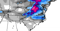
Depending on your perspective…the good news is that this storm will be a blockbuster. The bad news is that it looks to be busting the biggest blocks in VA rather than NC.
The track of the storm and upper-level closed low will ultimately determine who’s in the money (north) and who’s not (south). There has been lots of shuffling hither and yon with the low track among the models and between run cycles over the last several days from extremes of a SC/GA track to a Jersey track. Now though, as the upper-level energy that will spawn our storm has just this AM entered North American, we should expect the various models to converge on a consistent solution. We see that happening to an extent, but there is still a lot of waffling going on from run to run. Especially, in light of the fact that 50 miles difference in the track might mean the difference in 1″ vs. 6″ or rain vs. 2″.
What can be said with a high degree of certainty is that the storm will approach from the west, and as it nears the coast, it will rapidly intensify. As it does, a relatively large deformation band with moderate to heavy snow will form on the storm’s west in the cold air. It is in this deformation band that some places will get whacked with 1 to 2ft of snow and a howling wind (think Jan 2000 storm). As it appears now, central VA stands the best bet for heavy snow. The Euro has been consistently farther south with it’s low track for the past day or two vs. the American, GFS model. And remember that the Euro generally beats the GFS in mid-range skill scores. So while there is still time to hope for a continued trend south, it’s unlikely that there would be that much change to put us in the sweet spot in north central NC.
First guess for Raleigh…rain arrives on Tues, tapers off for a while as we get dry slotted on Wed AM, then rain begins again, mixes with and changes to snow Wed afternoon and we end up with a trace to an inch. Snow totals slope up as you head north toward Roxboro where they stand a better chance for appreciable accumulating snow to 4-6″.
More tomorrow…

Recent Comments