« Archives in October, 2016

Dark Side of the Moon

If Matthew is listening to a playlist, right now he’s probably playing (Pink) Floyd. (insert groan)

Thankfully, the eyewall of Matthew has maintained just offshore through FL.  As it moves northward, I still like the idea that it tracks over water or just grazes the coastline all the way to Cape Fear.  As mentioned last night, this will put eastern NC in a really bad position to receive a lot of rain.  The numerical modeling continues to highlight this threat and is converging on a solution that would produce widespread inland flooding.

I make the reference to Floyd in 1999 as the last great flooding event in eastern NC.  One of the things that exacerbated the flooding with Floyd was the fact that Hurricane Dennis had dumped several inches of rain over eastern NC just 10 days earlier.  This time around, areas around the region, including Fayetteville, are still recovering from flooding last week.
screen-shot-2016-10-07-at-12-20-25-pm

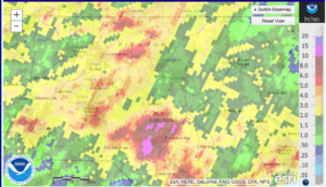
Here is the observed rainfall over the past 2 weeks centered over Raleigh and Fayetteville.


screen-shot-2016-10-07-at-12-38-31-pm


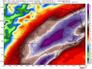
Here are predicted storm totals for Matthew from today’s 12Z GFS.  That’s a lot of rain on top of already saturated ground.


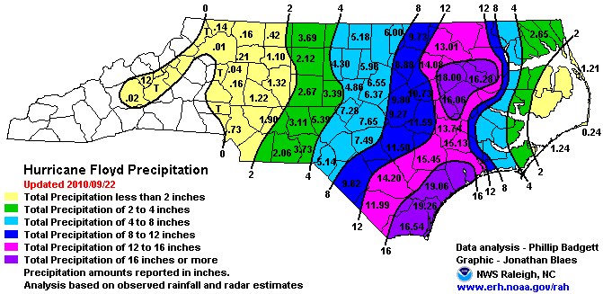
For comparison, let’s look at totals from Dennis followed by Floyd 10 days later in 1999…
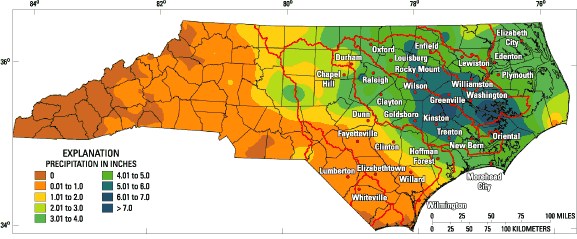
fig03


Here’s Dennis…


precip-19990915


Here’s Floyd…


It’s a serious situation to watch over the next 36 hrs.
 

[Untitled]

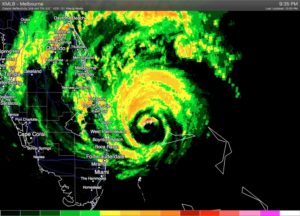
Matthew is poised to graze Florida’s Space Coast early tomorrow morning as a category 4 hurricane.  There is still much debate at this late hour as to whether it actually penetrates image-10-6-16-at-10-01-pminland or remains slightly offshore.  It’s the trickiest of forecasts with significant implications to subsequent storm strength farther north up the coast, including in NC.

I’ll leave the nowcasting to your local media outlets as Matthew tracks north.  What I’d like to put out there are a couple of points:

The models have waffled back and forth as to the track.  I’ve always been of the opinion that Matthew will track just offshore from Melbourne, FL all the way north to Cape Fear… mimicking the shape of the coastline.  Models have insisted on a sharp right turn out to sea near Charleston, but this evening’s 0Z guidance leans more towards my camp, suggesting a farther northward motion before the push to sea takes place.  Obviously, this would mean more rain, wind and surge for NC.

No matter the exact track, the interaction of Matthew with an inverted trough along the coast and the impinging cold front from the west, will combine to funnel a ton of moisture into eastern NC.  Indications this evening are that totals could trend higher.  At least 2-3″ in Raleigh on the low end.  More likely to be 4-6″ for us.


Matthew…so complicated

I suppose it’s time to weigh in on Matthew.

I’ve gotten a lot of emails asking for an update, saying that I’ve been silent.  Not really.  Twitter is a fairly effective tool for quick bursts of info.  And so, I encourage you to follow me there:  @trextrex14

There’s a lot of good information in the media on this storm, so I’ll write this post from the perspective that you’ve heard all of that…and more.  I hope to value add, to give you a couple of considerations in why the forecast could go perfectly as planned, or why it may be a total bust.

As of midday today, all the numerical guidance seemed to be converging to a tidy solution (albeit problematic in itself…for reasons I’ll talk about next).  That solution had the track of Matthew basically mirroring the concave SE coastline from FL thru GA and SC to NC then curving out to sea.  In this scenario, Matthew would track just offshore, pounding the coastline from FL to NC.  The problematic part of this is that since the shape of the coastline and the track would be nearly the same.  Any deviation of the track to the left would push the hurricane inland and significantly weaken Matthew for all locales north, i.e. less wind and surge, but still decent wind and lots of rain.  So that’s what’s hard if there was just that.

However, the Euro came in this afternoon with a literal curveball.  It depicted Matthew grazing the FL coast before doing a loop off GA back toward FL.  Then a couple of the Euro ensemble members had loops, and several had a hard right turn near GA.  Then the 18Z American ensembles came in continuing this new idea of out to sea and not up the coast.  Now, hot off the presses, the 0Z dynamical guidance echoes a similar theme…out to sea.

So, at this point I would like to be able to tell you there is confidence in a solution.  Tonight, there is more uncertainty than ever.  Hold tight, make plans for how to be prepared, but I would say there’s no need to act upon them until we see more data.  Remember we still have more than 3 days to work this out.