It’s too early to say for certain…but could it be that the Europeans will win yet another meteorological face-off over the battle-scarred Americans? This would, in fact, be great news for NC to have an out-to-sea ‘fish’ storm.
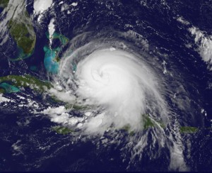
Here’s a beautiful picture of Joaquin whose official max winds are recorded at 125mph. One more tick up on the wind speed will put it at Cat 4 status. Joaquin continues drifting SW around the Bahamas and will not make a definitive turn to the north until tomorrow. And once that turns happens, it should remove some of the uncertainty that still exists.

The model spread is troubling. Many of last evening’s 0Z runs shifted their forecast tracks eastward (right) with the Euro holding firm to it’s out-to-sea solution. Interestingly, the US NAM, which was a lone ally of the Euro, flipped to the western (left) solution. Not that I trust the NAM…I can hardly find 5 or 6 good words to say about it, but it is interesting, nonetheless. The bottom line is that no one can say with certainty what the track will be at this time, but by tomorrow morning we should have a better grip on this. Let’s see who is right…or left…or correct 😉
I opened with the wildcard of Joaquin, because if it comes it will make an impending bad situation, devastating. So, it’s important to emphasize, no matter what happens to Joaquin, heavy rainfall tonight thru Sunday will cause widespread flooding in NC and SC. There will be general precip totals of 3-5″ for everyone, however there will also be an axis of training moisture that drops double to triple those amounts. Indications now are that this band will setup up near the NC/SC border or just into SC. In that scenario, the Triangle is spared the worst.
Obviously, lots of moving parts and things to keep an eye on. It’s time for the new GFS to come in. Let’s see if we stay consist or we flip.
Bon chance mes amis!
Recent Comments