Act III

The patrons are heading back in from the lobby as the entr’acte begins to play ahead of Act III…

For reference, my totals so far from the first two acts are 4.1″ snow, .4″ of sleet and .2″ of ice accrual.  The warming to freezing and just above in the eastern part of the Triangle helped tremendously in limiting ice accruals to just a couple tenths.  Hence, just spotty power outages this AM.

We should see the final bout of snow move in from west to east near lunchtime.  Heavy bursts of snow will be seen with some quick accumulations.  The best chances for highest totals are north of the Triangle, but the convective nature of these snow showers will mean that locally there could be some heavier amounts…think summertime thunderstorms and the localized nature of heavy rains with them.

1-2″ in Raleigh is a pretty good bet.  But again, with 1-2″/hour accumulation rates in these snow bursts, we could overachieve. I’ll monitor as it moves in and nowcast, as necessary.

Follow me on Twitter @trextrex14 for more frequent updates.

Act II

An impressive thrust of warm air has pushed the surface freezing line all the way into Wake county near Raleigh.  But it looks like that’s about as far west as it will make it.  Which means that eastern Wake will stop accruing ice, while western Wake accrues through the night.  Although, a more northerly flow later may push the freezing line back a little more to the east toward morning.

The near freezing temps will mean that ice accrual totals will fall under the crippling 1/2″ thresholds.  Still, western Wake and points west will realize several tenths of ice, which will be enough for power outages, especially as the winds kick up into the 20s with gusts in the 30s.

Then tomorrow as the colder air wraps around the backside of the storm it seems likely that we will see a period of snow showers to the tune of 1-3″ of snow.  The farther north, the more likely greater accumulations…something we’ll have to nowcast tomorrow.

Goodnight and here’s to keeping your power!

Act II and III

Act I is about to wind up for those in Wake Co.  And by wrap up I mean that the precip rates will decrease and become more showery in nature, and the bigger one is that the snow will changeover to sleet.  Difficult to say exactly, but this should happen over Wake Co. from SE to NW.  There are reports of sleet mixing in south now.  So maybe Raleigh has until 5 or so.  Until then heavy snow continues at the rate of 1″+ per hour.  Weathertrex headquarters has right at 4″, so this means that Act I will end up delivering more than advertised ranging from 4-7″ up from the 3-5″ progged.

Act II will be showery sleet and freezing rain this evening and overnight.  We’ll have to see how the radar fills tonight to ascertain if we will achieve the 1/2 of ice.  Will monitor.

Act III is tomorrow with the wraparound bonus snow.  Looks like 2-4″

Lots more storm to come!  Enjoy and be safe!

And Snow It Goes…

The snow is entering extreme southern Wake Co. at 11:45am.  It will arrive in Raleigh within the next hour…right on schedule.  And when it begins, it will be significant.  Expect snow rates of 1″ or even greater per hour.  This will quickly whiten things with a a good several inches before any change to sleet.  I’m happy to leave the forecast in place with the caveat of the possibility of higher accumulations on the front end.

With regard to the wrap-around snow expected tomorrow…it’s looking more likely, especially from the Triangle north to VA.  A couple inches with that seems like a safe bet.

Steady as she goes.  I’m eager to see the Euro’s latest track, which will help with understanding just how much warm air works in.

And Another Thing…

First, I agree with Fishel and his isothermal rant…especially in light of the fact that precipitation rates will be high, dictated by mesoscale banding.

But the other thing I wanted to address is the so-called wrap around or comma head or deformation band.  The new GFS continues in the trend of significant supplemental snows in association with this.  However, this new run really cranks it up to the tune of several addition inches.  We’ll see if there is consistency in subsequent runs and the other models.

And finally, you should be aware of a clipper system progged to dive over NC Friday night into early Sat AM.  This system could drop another inch or so of nuisance snow.  Just something to watch for now.

Actually as I think about it, we have a growing list of things to watch…

I Wonder If the Triangle Will Be in the ‘Sleet’ Spot

Watching the American models come in tonight, I’m wondering if maybe the Triangle might end up in the ‘sleet’ spot.  Here’s my train of thought.  I wonder if there will be a relative low in ‘inches of stuff on the ground’ in between the heftier snow totals to the west and the ice accrual glazing to the east.  So if there is zone which ends up staying for a prolonged period as sleet, then maybe it actually works out with lower snow/sleet totals and less of the dangerous icing.  I’m not saying I know the answer here.  Just pondering.  Now question this would be a preferable solution with far fewer power outages.

At this point, we’ll just leave the current outline as is, but perhaps the snow might be overdone in favor of more sleet and freezing rain.  Let’s look at the new Euro tonight.  And then perhaps more exacting might be tomorrow AM’s run cycle when have the benefit of initializations with the storm already in progress.  Although, it should be noted that this evening’s runs had the benefit of supplemental hurricane hunter aircraft data from a special mission flown to improve the accuracy of the data-poor analysis over the Gulf of Mexico.

Fun Stuff!

The Main Event

Round 1 is coming to a close for NC, but not before some impressive snow totals were squeezed out, especially in places like New Bern where up to 6″ have been reported.  Elsewhere, south of Wake county more general 1-4″ accumulations were observed into the Sandhills.

Today’s snow was a foretaste of the much stronger headline storm that arrives tomorrow.  I don’t have big changes to make at this time from previously outlined ideas.  The new 12Z Euro shows a slight shift to the east of the storm track, more in-line last night’s Euro ensemble mean.  But I continue to favor a track even just a little farther east, which would take it right over Cape Hatteras.  This is where I could be wrong, in which case snow totals would be reduced in favor of more ice.

As I’ve said before the QPF (liquid equivalent) is becoming a matter of certainty for this event.  Latest SREF (short term ensemble suite) mean QPF is 1.35.  The favored Euro 12Z deterministic is at 1.6″ and last night’s Euro ensemble mean was also right at 1.6″.  Again, lots of precip to fall.  And most, if not all will be frozen.

To review what will happen tomorrow.  Precip should arrive in Triangle around lunch in the form of snow.  Snow should accumulate several inches before mixing with and changing to sleet.  Sleet should accumulate quite a bit before changing to freezing rain. Then, as the low passes there is growing evidence that more snow will occur to the tune of a couple of inches in a formidable deformation zone wrapping about the comma head of the surface cyclone.

Blah, blah, blah…just give me the number!  Here’s my thought for Raleigh, which is basically the same as yesterday, plus bonus on the backside.  3-5″ of snow/sleet, plus .35-.5″ of ice, plus 1-3″ of snow Thurs AM in the comma head.

This evening maybe we can talk about what might go wrong…like Gulf convention limiting northward moisture transport and getting dry slotted and a far inland storm track that would cause a changeover to rain even to the Triangle.

Steady Eddy

There is no reason to change any of the outlines at this point.  I would like to reiterate the threat for significant power outages with widespread power outages likely from 1/4 to 1/2″ of ice with the potential for up to 3/4″, which would be debilitating.  If anything, the tendency would be to reduce snow/sleet totals and raise the freezing rain/ice totals.

We’re still nearly 48 hrs out from the event, so we have plenty of time to make refinements to the forecast.  But you all have time to take care of business and prep for a couple of days without power.  And while power outages can be more random than the weather, it’s better to be prepared than to be cold and eating Beenie-Weenies in your big coat!

More tomorrow.


Liquid Equivalent/QPF

Things continue on track for the main storm to arrive Wed.  We are experiencing a minor ‘flurry’ of activity now.  And we can expect the 2nd round of snow tomorrow, especially south of the Triangle into SC.  Probably very little if any accumulation with that this far north, but there will be accumulations south to the tune of a couple inches.

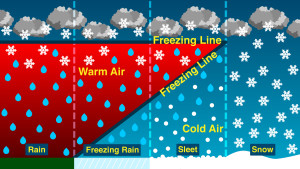
The headliner begins to spread precip in the Triangle late morning or just after lunch on Wednesday.  It will begin as snow, change to sleet and then to freezing rain.  The biggest question, which remains without an answer at this point, is how long does it precipitate in each form at any given location.  What is very clear at this point and the main point I’d like to drive home is that this storm will drop a lot of ‘something’.  What form that ‘something’ will take will be the debate.  In the met world we call this QPF (quantitative precipitation forecast) or liquid equivalent.  So even though there is uncertainty with how much of each p-type will occur in your backyard, what is more certain is there will be a lot of QPF.  And by a lot I mean over an inch of liquid equivalent.  Consensus among various models and ensembles of those models is centering in on between 1 and 1.5″ of liquid equivalent.  From the Triangle and to the west all this precip will be in some version of something frozen.  So anyway you look at it, it spells crippling winter storm.  Toward Winston-Salem through the Foothills down to Shelby looks confidently all snow.  Then points east of this line could begin to mix with sleet as the storm pulls in a mid-level warm tongue off the Atlantic.  And even farther east then there’s freezing rain to deal with.  Finally, along the eastern Sandhills and Coastal Plain the precip is likely to change to all rain.

Where all these transition zones line up will depend on the exact track of the surface low.  There is still wrestling going on with the track, but not by wide swings…more like quibbling over 100 miles…again, which makes a big difference inland.  Over the next 3-4 run cycles we’ll play these watch the track ebb back and forth, while hoping to get it nailed down.

I promised a map for this afternoon, but instead I’d like to offer a first guess for the Triangle and hold off on a map until tomorrow.  For the Triangle, we begin the real accumulating snow Wed near lunch.  We see 3 or 4 inches before changing to sleet and then add about 1/2″ of accrual of ice from freezing rain.  Then the mid-level cold pushes out the warm tongue on the backside of the low and we change back over to snow for a little more bonus accumulation.  Use this as a guideline to interpolate what you get.  As you go west, you add more snow and less ice.  So that in Winston-Salem they are looking at a foot.  As you go east and south, you get less snow and more ice and eventually a changeover to rain.

Bottom line is that now is the time to be making preparations.  You want to think about changing travel plans (all up the East Coast because this will ride up the coast).  You should also make preparations for loss of power.  1/2″ of ice would be crippling.

NWS is issuing Winter Storm Watches all around valid beginning Wed.

More to come…


The Haters Attack the Technical

First let’s be clear.  The previous post on ensembles was supposed to give broad brushed background information behind the mechanics of ensemble modeling.  That post was not intended to make any pronouncements on the upcoming storm, except to say the Euro is agreeing with itself.  Just information, for you in your next water cooler chat.

Now…what’s new with tonight’s models.  The NAM shows the Triangle as an ice rink. (I think it’s too far west with the low.)  The GFS gives a decent several inches with some sleet on top.  The Euro won’t be in until another hour or so.  But there is also support building in the shorter term US ensembles, the so called SREF.  The 21Z runs are trending totals of the ensemble means up quite impressively…10-12″ in Charlotte and 7-8″ in Raleigh.  Again, this is certainly not a forecast.  Just some interesting jockeying going on ahead of the main event.

Final word for tonight.  This will be a major disruptive event for NC.  Best 1st guess for Raleigh is a couple inches of snow followed by a layer of sleet followed by a glaze of the dreaded freezing rain.  Timing is questionable, but probably Wed AM to begin in the Triangle.  Areas near the SC border begin Tues.

Tomorrow you might begin thinking of changing your plans for Wed and Thus. I’ll have a full outline and a guess map tomorrow, early afternoon.