« Archives in January, 2016

Major East Coast Storm

There seems to be little question as to whether this weekend’s major East Coast storm will come to pass.  The questions are where and how much.

It appears likely a good swath of real estate will be measuring snow totals in feet as opposed to inches.  It appears likely this will be a monster storm.  It appears likely many coastal areas north of NC will experience significant beach erosion coinciding with a full moon.  It appears likely gale force winds will be felt over most of the Mid-Atlantic and NE, if not a couple of hurricane force gusts mixed in.  So…it’s likely to be the storm of the year, if not the storm of the past several.  If you have plans to go anywhere north of the NC/VA border this weekend, change them.

For us the questions are how much snow, how much sleet, any freezing rain? and how much rain?

It looks like we’ll should have frozen something on the front end and back end.  But, what about the middle?  Changeover to rain? and for how long and how much QPF goes to that?

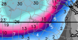
Most likely outcome for the Triangle at this point seems to be some frozen at the onset, with changeover to rain for a good portion of the storm, followed by snow at the end.  Indications 4 days out are that we should expect a rather sharp gradient in the haves and have nots.  That is, over a relatively short distance, snow totals should ramp up.  For example, see this projection. (and not to be one of those proliferating NWP snowfall maps…this is to show the gradient)

Screen Shot 2016-01-19 at 12.25.01 AM

You see how quickly we go from 3″ at RDU to 13″ at Roxboro to 30″ in Central VA.  Again, don’t take this as literal.  Just one piece of guidance for real life humans to interpret and come up with their best assessment.

Bottom line, we don’t know yet.  And I imagine we’ll be fine tuning this up to Thursday night.  There will be significant wintry precip in NC.  The mountains are a near lock…east of there we’ll see how it works.

In the meantime, we can expect a round of flurries or a lucky snow shower on Wednesday evening.  The QPF (amount of actual water equivalent) will be very small, but anything that falls should have no trouble sticking around with the antecedent cold temps.  We will monitor it assiduously, as a little snow goes a long way on frozen ground to make for bad driving a la Jan 19th 2005…lo these 10 years ago.


End of Week Storm

Hope everyone enjoyed their cometic snow event this morning!

I thought I’d follow up on my earlier alert for end of this week, especially since the snow hype machine will begin in full force after the last couple runs of the Euro (and to be fair the GFS, too)

Yes, it seems a pretty good bet there will be a significant East Coast winter storm into the weekend.  But the range of outcomes with regard to sensible weather and it’s impact literally run the spectrum.  At this point, we need to be alert for the possibility a strong storm with significant wintry consequences over a good portion of the East Coast from NC north thru New England.  There’s a lot that could go wrong…so, let’s wait and watch.

Snow-Sleet-Freezing-Rain

Right now, it looks like NC would be on the southern end of the action with a mixed bag in the Triangle.  It’s a classic setup with more proportion of snow north and west with the mountains the big winners.  Interesting to note that the timeline has been trending faster by the numerical guidance, which helps from a cold-air-in-place-perspective.  Not in our favor, is the low origin, which would traverse the Tennessee Valley.  A more favorable setup for central NC would have the low farther south.

There no doubt the Euro is the model with the best skill in these situations, but it doesn’t mean it’s right on day 5 or 6, just that it’s the best of what we have.  Should be fun to see what sort of corroboration exists for the major storm in the operational run when the ensembles come out in a couple hours.

Again, plenty of time to dissect this over the next couple days.  Don’t run to the grocery yet!


sNOw News Is Bad News

Happy New Year!

Curiously, there seems to be quite a buzz about the potential for 14 flakes of snow this weekend.  And with the buzz come many questions directed my way.  So, I thought I’d take a second to clarify that if I am not excited about the possibility of something wintry (or otherwise meteorologically spectacular), then I probably won’t post.  That is…if something is going to be a non-event (like the flurries before Christmas), there is really no need to update.  So, going forward, consider no news as bad news for the snow lovers out there.  And if you want more frequent thoughts from me on the weather you can follow me on twitter @trextrex14.  I tend to tweet with short updates especially when an extended post is not warranted.

All this being said, this weekend looks quite unimpressive.  The cold will follow Monday and beyond, and the cold will be significant.  But more intriguing is a system pegged for late next week into weekend.  Let’s watch that to see if we lovers of the white flake from above will be more than satiated!