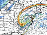
A quick update to confirm that we’re still on track for a moderate to possibly heavy winter storm, particularly in eastern NC.
As the arctic front enters NC on Thursday, rain will begin to changeover to sleet and snow as the cold air invades into Thursday evening and overnight. The front will serve as a focusing mechanism for waves of low pressure to ride from SW to NE along the Southeast Coast.
There are still plenty of details to be ironed out, but 3 days out, the models are converging on a consensus for an axis of heaviest snow lining up from Albemarle to Raleigh to Norfolk. Immediately, southeast of this line there looks to be the axis of heavy sleet.
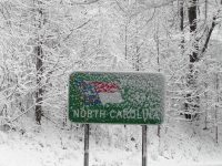
Behind the storm it will be very cold. We’ll be dealing with whatever falls on the ground for a while after the storm is long gone.
I’ll have a more complete analysis late tonight.


Recent Comments