Roll Up Your Knickers, It’s Gonna Be Hot!

The weather for tomorrow’s golf outing still looks great…just a little hotter than it first appeared it might be.

After a chilly early morning low in the low 50s, we should see plenty of sun with temperatures approaching 80 by tee time at high noon.  The temperature will continue to rise through the afternoon, popping up to a high of 88 around 4pm.  And throughout the day as the temperature rises, you will also feel it become more muggy and summer-like with an influx of moisture.  Our current dewpoints in the low 40s this afternoon will increase to about 60 tomorrow afternoon, roughly doubling the amount of water vapor in the air.

It’s the first real taste of summer.  You know the drill…wear light colored clothing, drink plenty of water and put on the sunscreen.

Good luck!

Beautiful Weather for Golf on Wednesday!

After a couple of unseasonably chilly starts over the several mornings (especially Tues AM), we should be treated to an ideal spring day on Wednesday for Hayes Barton UMC’s 3rd  ‘A Golfing Disaster’ Tournament.

My job will be an especially easy one this time around with the forecast for the tee time.  High pressure will be in control and we can expect mostly sunny skies with high right around 80°.  

There is still time to sneak under the wire and add your name to our list of golfers.  Register before tonight to support this important disaster missions fundraiser!

agolfingdisaster.eventbrite.com


Hayes Barton UMC ‘A Golfing Disaster’ Tournament


We are pleased to announce that WeatherTrex.com has been named the exclusive  provider of weather forecasts for Hayes Barton UMC’s 3rd Annual ‘A Golfing Disaster’ Tournament coming up next Wed, May 15th at beautiful Lonnie Poole Golf Course on the NC State University Campus.

Under the agreement, WeatherTrex.com will provide weather forecasts in the days leading up to the event and nowcasting on game day from the shotgun start.  The first outlook will be issued over the weekend, and golfers can access WeatherTrex.com during the event on their mobile devices for updates as necessary.

There is still time to register your foursome or become a sponsor yourself for this important fundraiser that enables us to quickly respond to the devastation in the wake of the next looming natural disaster.

To sign up to play visit:

agolfingdisaster.eventbrite.com

To sign up as a sponsor visit:

agolfingdisastersponsor1.eventbrite.com

2013 Golf Disaster Promo


30 Years Ago…

…a certain ‘Cinderella Team’ began its march to an unlikely National Championship.  But does anyone remember another significant Cinderella story during that run?

That was Raleigh’s last big late-season snow…over 7 inches on March 24th.

Here we are 30 years later.  I say it’s time for a repeat on both accounts!  Here’s to some wishful thinking!

Screen Shot 2013-03-18 at 11.46.57 AM

For fun…here’s one model’s snow accumulation ending 3/24/13.  Plenty of time to fret over this.  Just something to watch for now.  I’m sure I don’t have to remind you how difficult it would be to pull this off so late in the season…

But hey, if the glass slipper fits…!!!

Wide Left

…and not even by a little bit.  A couple of days ago this looked like a couple-hundred-mile near-miss.  Tonight, it’s kind of amazing to concede this system will go way north and concentrate the max snows north VA and MD then continue NE to the Northeast.  A Northeast solution seemed an outlier solution just last night.  That which befuddles me, intrigues me.

For NC, after tonight’s rain, we’re left with a passing snow shower tomorrow morning, at best.  The bigger story will be the wind.

Looking ahead, I’ll venture to say that a spring teaser warm-up follows end of the week, but after that there will be a cold snap.  Will the cold snap combine for a cold 40° rain or a little frozen mischievous?

Blockbuster!

Depending on your perspective…the good news is that this storm will be a blockbuster.  The bad news is that it looks to be busting the biggest blocks in VA rather than NC.

The track of the storm and upper-level closed low will ultimately determine who’s in the money (north) and who’s not (south).  There has been lots of shuffling hither and yon with the low track among the models and between run cycles over the last several days from extremes of a SC/GA track to a Jersey track.  Now though, as the upper-level energy that will spawn our storm has just this AM entered North American, we should expect the various models to converge on a consistent solution.  We see that happening to an extent, but there is still a lot of waffling going on from run to run.  Especially, in light of the fact that 50 miles difference in the track might mean the difference in 1″ vs. 6″ or rain vs. 2″.

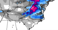
What can be said with a high degree of certainty is that the storm will approach from the west, and as it nears the coast, it will rapidly intensify.  As it does, a relatively large deformation band with moderate to heavy snow will form on the storm’s west in the cold air.  It is in this deformation band that some places will get whacked with 1 to 2ft of snow and a howling wind (think Jan 2000 storm).  As it appears now, central VA stands the best bet for heavy snow.  The Euro has been consistently farther south with it’s low track for the past day or two vs. the American, GFS model.  And remember that the Euro generally beats the GFS in mid-range skill scores.  So while there is still time to hope for a continued trend south, it’s unlikely that there would be that much change to put us in the sweet spot in north central NC.

First guess for Raleigh…rain arrives on Tues, tapers off for a while as we get dry slotted on Wed AM, then rain begins again, mixes with and changes to snow Wed afternoon and we end up with a trace to an inch.  Snow totals slope up as you head north toward Roxboro where they stand a better chance for appreciable accumulating snow to 4-6″.

More tomorrow…


The Snow March Begins

Let the hype begin!

Now that we’re talking about day 6 in the forecast, you’ll see the media outlets feel like they can utter the dreaded 4-letter S word.  The modeling on this one has been remarkably consistent for a couple of days now for feature at the 10-day range.  Of course, the exact track will ultimately determine precip type and how much of it.  This storm will come from the west and intensify at the coast.  Lots of details to figure out, so at this point it’s just something to factor into your Wednesday planning contingencies.  Your next question is probably…”could this be a ‘good’ snow?”  The answer is…yes, there is potential there for a several inch event.  That being said, there is the potential for the classic NC 35° rain.  And I’ll add on that there is also actually the potential that the storm track is suppressed so far south that this turns into a SC snow instead of NC.

One last thing…yesterday, I was reminded of the difficulty of getting it to snow in March in NC when I got into my truck that had been sitting in the sun all day…hot.  The sun angle is getting pretty high now, so you have to have a steady supply of fresh cold air to make the magic happen this late in the year.  And if it does happen, a lot of times the snow comes, is pretty, and  then is gone before you blink your eyes….which is probably a nice thing for a lot of people.

Oh and I forgot to talk about this weekend…yes, there may be a sprinkle or a flurry Sat PM.  Nothing to worry about for that one.  Save your grocery money for next Wednesday 😉

Cold’s Coming, But Will the White?

Quick update…

First, sorry I couldn’t post on the non-event on last Friday AM.  I was on a mission trip and too busy to post on something that wasn’t gonna happen.

Now to the upcoming…a huge trough in the eastern US comes into play over the weekend.  We have the possibility of a couple of winter storms from late Sat thru Thurs.  Sat night into Sun, there is much uncertainty about the possibility a coastal storm will develop with the many-times-elusive wrap around moisture for snow.  At this point I’ll buy into a couple of flurries.

But then, things get more interesting a couple days later when a southern-track, Dixie-special could be on the table.  In my mind, this may be the end all, be all to cap the 2013 winter season.  Could be waaaay nice.

More on this later in the week, just a heads up for now.


Sticky Situation

It’s a beautiful snow here in Raleigh as the big wet flakes are now piling up on everything but the roads.  And that will continue to be the situation until late this afternoon and evening when the real cold air arrives.  The enhanced precipitation rates over Wake Co. in particular have done an excellent job of dynamically cooling the air temp to just above freezing.  So, as long as it continues to snow at least moderately, the accumulating snow will win the battle over warm antecedent ground temps and the diffuse insolation thru the clouds.  This first wave of snow should taper off this afternoon and then the debate really becomes how much if any precip shows back up late afternoon and evening in association with the developing low off the coast.  The likely bet for now is that it’s nothing more that a couple of snow showers, but it’s a situation that needs to be watched, especially for NE NC toward Roanoke Rapids and Va. Beach.

For now, enjoy the snow!

Split Decision

There’s more disagreement on this weekend’s snow than there is in the U.S. Congress.  And also like Congress, there may no deal cut until the final hour.

But…the trend has been to form the storm closer to the coast and therefore produce more precip farther west.  We’ll probably see the precip begin as rain and transition over the snow.  The best bet for accumulation in Raleigh is 1-2″ and I could see 3 happening.  Higher precip amounts NW and west could result in more snow toward Rocky Mount and Roanoke Rapids, but the cold air will take longer to get there.  So, you would be fighting that battle to balance the two.  As ground temps are high and it’s currently a lovely 61 at RDU, accumulation will happen last (if at all) on the roads.

As I said last night, this could swing either way on a dime.  And it’s this type of situation that feeds the fire that meteorologists are roasted over.  Here’s to some BBQ!