« Posts by trex

Another Mess for the End of the Week?

A couple of quick points:

1)  The coldest air since last winter is on tap for midweek.  Highs Tues and Wed will not make it out of the 30s, despite lots of sun and some harmless cirrus.  Lows Tues night should reach the upper teens, especially outside the city.

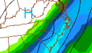
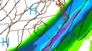
2)  It should begin to moderate late week as the next front swings thru bringing a cold rain, but secondary low development along the front could make for another wintry mess and forecast headache late Friday into Sat.

And, the Dance is Over

Unless, I’m missing something that an old, washed-up, out-of-practice meteorologist should be seeing…I’m gonna turn the lights up and declare the dance over.

There could be a couple convective bursts that lay down another layer or two.  But at this point, any more appreciable snow in areas where there is just a dusting now, would shock me.

Enjoy what you have and be careful with black ice tomorrow morning.


May I Have This Dance?

At the risk of being Captain Obvious, the colder air has arrived and the changeover is nearly complete thru most of the Triangle.  Precipitation rates will now dictate local accumulations.  We should see a lull in the precip intensity in the next hour, before the bands in association with the upper-level vortex, currently over upstate SC, rotate thru here after midnight.  In the lighter bands in the interim, you could very well see a rain/sleet mix, until the final snow.

So, enjoy the snow.  The bursts should make for some real purty!

And so, as the dance comes to a close, she finally made it.  We sway as Madonna plays loud and a teacher yells… “daylight, kids!  let me see daylight!”

Enjoy this one…Crazy for You

Waiting at the Dance

Well, here I am…all gussied up and smelling nice.  The music is thumping and the gym is dotted with groups of awkward adolescents swaying in clumsy cadence.  Now all she has to do is show up.  She…being the cold air, of course.

The thinking behind the forecast is basically unchanged from yesterday.  The models have been quite consistent and in agreement on the system’s evolution.  Yet, even as it would seem that the snow is on, the same nagging questions about the arrival of ‘the cold’ linger.  That, combined with warm ground temps, makes me worry.  Finally, the 18Z models dry us out a little quicker on the back end, which is also troubling.

It will definitely snow.  But, the accumulation of snow is predicated solely on the fact that it’s going to snow so hard to overcome a lot of warmth in the boundary layer.  It’s one of those situations where everyone will get some grassy accumulation, but maybe not much else unless the heavy snow is realized.  Under those heavy snow bands, the snow will accumulate quickly, maybe as much as 2+ inches per hour…and these are the locations that could see 5″.

As we get into early evening and we see what the radar signature looks like, we should be able to nowcast more accurately.  For now, i’m cautiously optimistic to stand by what I outlined last night, which is pretty consistent with the NWS and media.  But my tendency would be to skew to the low side rather than the high side until we see evidence that the cold is making real progress.  In Raleigh, I would think we won’t changeover until 9.

So until then, I’ll be hanging out at the dance, just waiting and listening to sappy 80s power ballads.  Click the play button to enjoy this one…


Ok, I’m a Sucker for Love…

Alright, I give in.  I’ll be waiting at the dance…again.  I’m ready to put out my first guess for accumulations.

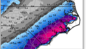
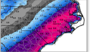
Looks like the dynamics of this storm might be so impressive as to generate thunder snow.  The last thunder snow we had in the Triangle was during the most impressive snow we’ve ever seen, back in Jan (24th) of 2000 with 20″+.  So, tomorrow night when you’re out watching it snow, look for cloud to cloud lightning, even if it’s difficult to hear the thunder.  And these impressive dynamics could be the key to realizing impressive snow accumulations in spite of warm ground temps from our recent Indian Summer.  I’m thinking that after we see the changeover tomorrow evening, we’ll see a general swath of 1-3″ in the Triangle and on either side of the line I prescribed in my previous post…obviously with the dustings to 1″ on southern and easterly edges and the higher totals to the north and west.  But, the wildcard will be how the mesoscale bands set up.  The bands of convective snow could add another 1-2″ on top of these more general totals.  The sweet spot, though, for those near the Triangle looks to be just over the Virginia border where, depending on how those bands set up, should range 5-10″.

I’ll fine tune this tomorrow.


At the Risk of Being Heartbroken…

I feel like I’m in middle school…I’ve been talking with a cute girl.  She’s very flirty.  I invite her to the dance.  We agree to meet there because she’s going to come late.  I wait.  The clock ticks on.  There are only a few more minutes before the dance is over.  She’s still not here.  The last song begins to play.  Where is she?  You see where this is going.

Tomorrow’s situation is a classic setup for heartbreak of the NC snow lover.  Lots of moisture and lots of rain on the front end of the storm.  Plenty of cold air advection and dynamic cooling aloft to suggest a changeover to snow on the back end.  But therein lies the rub.  Time after time it seems so clear, only to have hopes dashed as the cold air rushes in behind the storm and erodes the moisture field.  This girl has stood me up at the dance too many times for me to easily buy it this go round.  That’s why from the get-go on this one, I’ve been saying that I’m skeptical.

The past several model runs have come into convincing consensus as to the evolution of the approaching storm.  As I mentioned, there will be good soaking rains during the day Thursday, transitioning thru a rain/snow mix to all snow overnight into early Friday morning.  Of course, the question is…when is the change in relation to the end of the precipitation?  (Will she show up before the dance is over?)

At this point I’m ready to say that it will snow north and west of a line from Rocky Mount to the Triangle to the just north of Charlotte.  And probably, that line will end up being the line for accumulating snow.  North and west of that line there will be significant snows…especially, toward Greensboro and Roxboro into southern Virginia and of course, the mountains.  More specifics later.

We’ll see how the dance goes this time around.  Maybe she’ll show up early for bigger snows, or maybe it’ll be the same scenario where we’re left waiting for her to show as the music fades…

For those who grew up in the 80s, click on the play button, close your eyes and picture the middle school dance…

Borderline…feels like I’m gonna lose my mind…

Looks like the Thurs/Fri event will be a borderline event.  There’s no reason to suppose that we will be dealing with any more than a nuisance cold rain to sleet and/or wet snow event.  While it seems the trend is for a bit of wintry fun, the likelihood of anything more than pretty is remote.

Then, we’ll feel the Arctic chill early next week, but indications now are that we will remain dry.

Remember, if you were a previous subscriber to the site and would like to continue to receive updates on new posts, then you need to re-register on the “subscribe” box.  My site was hacked in December and we essentially had to start over.


Friday Looks Interesting…

Looks like we have the potential for a lot of rain late Mon thru early Wed with our short Indian Summer coming to an end.  Monday should still be unseasonably warm, but Tues and Wed will feature temps in the 40s with an intermittent driving rain.

The interesting part comes along overnight Thursday with a southern stream system rotating out of the southwest.  It looks to be weakening as it approaches us, and the cold air to work with is borderline.  But as this is our first shot at some winter this season, we at least have something to monitor.

No matter how the late week system works out, the overall pattern will be more favorable into the following week for another chance or two at some wintry precip for NC Carolina.

What the Hack?!?!

WeatherTrex was hacked before Christmas and had to be wiped clean to start over.  If you were previously a subscriber, you will have to reregister if you would like to continue receiving emails when a new post is published.