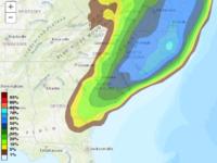
Snow appears likely to be flying in eastern NC beginning Wed afternoon thru Thursday.
What first looked to be an out-to-sea storm system only grazing the Outer Banks, now looks destined to swing farther westward, spreading snow into at least the eastern third of NC. There are major discrepancies between the coarse global models and the higher resolution mesoscale models. The global models tend to be farther east with the precipitation shield. The mesoscale models are farther west and insist on explosive cyclogenesis that will make for enhanced precipitation totals as well as gale force, gusty winds.
At this point, there is much uncertainty as to the evolution of the storm. We will look for more clarity on the upper level phasing through the modeling that comes later tonight and tomorrow morning. A sharp back edge of snow accumulations seems likely. So…will Raleigh have some flurries or a dusting…or will Raleigh get several inches? A range of possibilities are on the table at this point with this highly dynamic system.
Stay tuned.
Recent Comments