« Posts by trex

So Many Variables to Consider

Let’s deal with tomorrow first…

In interpreting meteorological model data, the saying goes…the trend is your friend.  Over the last 24 hrs, clearly, the trend has been to strengthen the first surface low farther westward.  So much so, that this evening’s American models show the normally more reserved GFS joining the NAM in backing the 1/4″ liquid equivalent contour back to Raleigh.  And you all know the rule of thumb for converting liquid equivalent to snow… In general, use a 10:1 ratio (if it’s colder (combination of aloft and surface) use a higher ratio, which is rare in NC…or if it’s close to freezing  and/or mixed with sleet or graupel, then you’ll use a lower ratio)  So, if you believe this evening’s latest models then you think we could see a couple inches tomorrow.  I’m still not convinced.  Although, cold air is streaming in this evening, it seems unlikely to realize all of that QPF (meteorologist-ese for liquid equiv).  At this point, I would expect a dusting to an inch beginning early morning tomorrow.  Hopefully, not too many road problems unless we have a panic situation like 10 years ago!  Snow should increase in significance farther east and south where deeper moisture will be present.  Closer to the coast you’ll be fighting warmer air.  For the Triangle, let’s monitor the radar trends overnight and see if it looks like the significant precip shield will, in fact, extend this far west.


Dice-Dice-baby---4c9dfb5fa2f22_hiresLet’s talk about Wed nite into Thurs AM…

The thing about Wednesday is that with a good deal of sun during the day, surface temperatures could pop into the upper 40s.  If that is the case, a significant first portion of the snow that falls would be lost from accumulation totals to cooling the surface.  But…what if we have a more impressive showing tomorrow in snow cover?  In that case, we might not warm as much Wednesday afternoon.

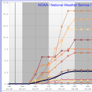
At any rate, it seems that significant QPF will be realized over central NC overnite Wed/Thurs.  How much initial QPF will be lost is yet to understand.  There is ensemble agreement with >1/2″ of QPF for the event.  The disconcerting part of the equation is that, in particular, the GFS deterministic continues to track the low center east with only .1-.2″ of QPF for Raleigh.  In fact, this evening’s 0Z operational run of the GFS prints more QPF for RDU with tomorrow’s initial wave, rather than with the second storm.  A coup?   Maybe…but the problem is that the deterministic version of the GFS has been consistently tracking the low east of it’s ensemble suite mean.  Not good.

Thank you for reading to the end of my blah, blah, blah.  The bottom line is that there exists much uncertainty both Tuesday and late Wed.  And…the evidence suggests that there is potential for significant snowfall.  Tomorrow it could be a pretty snow shower, or…a accumulating snow to a 2″.  For Wed nite into Thurs AM, it could be as little as an inch, but as much 9.  So, let’s play it low key and we’ll talk tomorrow as to how this evolves.


Bonus!

Today has gone according to plan, but perhaps I have not been giving enough credit to the potential for snow for tomorrow.  As I mentioned last night, the southern stream is very active with various waves blipping along. As they round the bend at the SouthEastern coast, there is the potential for development.  Tomorrow’s wave is looking more promising for development farther west in today’s modeling.  So, what looked to be a flurry or two, now looks to be more snow showery with the potential for some light accumulations, especially on grassy surfaces all the way back to central NC.  Certainly the (relatively) heavier precip will be near the coast, but wintry precip will be tampered by a warmer boundary layer.  Taken literally, the 18Z NAM, would be quite snowy, but there’s not much evidence to bit that hard yet.  Just something to watch.

As for the main event for Wed evening into Thursday AM.  While the operational GFS is the most easterly of the model data, it’s ensemble members are generally west into central NC with significant precip.  The Euro is in a similar camp with it’s ensemble mean being wetter than the deterministic.  All this to say that the stage is set for a potentially significant snowfall.

I’ll not mention totals for Wed night’s event until later tonight.  I wouldn’t want anyone to get to excited too soon.


The Signal and the Noise

Forgive me Nate Silver for my title ripoff. (but it’s really a great book…especially if you like weather, baseball and politics!)

signal_in_noiseThe noise part…over the past couple of days, the numerical modeling for the upcoming week has been all over the place.  With a suppressed southern storm track, various runs and models have popped a storm into the Carolinas at some point.  But there has been little consistency from model to model or run to run or among the ensemble members.  There has, however, been plenty of indication in the ensembles that something might be out there.  (again, with no consistency in time or space)  I told a friend tonight that it was like the CIA hearing “chatter” on a possible terrorist attack, but not having any idea of the specificity of the event.  So…you keep listening and hopefully things firm up sooner rather than later.

Today, it seems things may be turning the corner in the way of clarification.  The 12z Euro was very bullish in its operational and ensemble suite, depicting a significant winter storm for overnight Wednesday into Thursday morning.   There is not enough evidence yet, but we need to monitor how far west the the storm track might be.  It is curious that so many ensemble members had a strong hit on central NC.   With the previously large spread in solutions, I would have expected a wide spread of low tracks.  But the operational and deterministic were in agreement with .6″ of liquid equivalent of frozen precip at RDU.  This evening’s NAM has trended west with it’s storm track (although to be fair, we’re just coming into the scope of it’s time range, so trends can just now be discerned.)  We’ll look to see if the GFS, which has been out to sea, will trend westward.  And then, really telling will be the 0Z Euro and it’s ensembles to see if their 12Z runs were a one-off or not.

Also, some of you maybe concerned about tomorrow.  Don’t be.  If we do have any frozen mixing in or changing over, it should be inconsequential.


4:45 Update

That was fun.  The initial lighter snow showers came thru on schedule about 4.

The next band is the heavier more substantial band.  It is just moving into Durham now.  It should arrive in Raleigh by 5:15 or so depending on where you are west to east.  This is the band that will be capable of producing a quick coating to 1/2″  maybe 1″ for a couple of lucky ones.  Roads should be safe having absorbed a lot of energy today from a full day of sun.

Happy Snow…it should be pretty!

Arctic Front This Afternoon with Snow Squalls

Bitter cold air arrives tonight behind the arctic front that will be accompanied by gusty winds and the possibility of a moderate to heavy snow squall for the lucky.  The sun has done a great job this afternoon warming up the boundary layer under beautiful blues skies.  This will all rapidly change over the next couple hours as the skies darken and clouds thicken up.

Radar trends and short-term high resolution models indicate that the snow bands should arrive in the Triangle about 4pm.  With a steep temperature drop in the atmosphere are you go up in height, we expect a cellular, convective appearance to the bands…more like what you would expect in the summer with a line of thunderstorms.  And just the same as with a line of thunderstorms, it is hit or miss as to who is under the heaviest cells.  There will be some places under the more vigorous cells that see heavy snow for a brief period.  It should be very pretty and satisfy those who were disappointed in the the sleet on Monday.  Under one of these heavy bands, there could be a quick flash accumulation of up to an inch (roads will be hard to accumulate on if they have been in the sun).  Don’t panic.  It will be over before you know it.  Taken literally, the latest short-term modeling suggests that after a couple lighter snow showers come thru Raleigh about 4pm, that a  heavier cell will head thru Wake Co. between 5 and 6pm.  Should be fun to see if that pans out.

Then bundle up!  Near 10 tonight and near 0 tomorrow night.

There could be a couple hours of light wintry weather on Sat before changing to rain.  Low confidence on this.

Then next week there are lots of questions about another winter storm.  Models are all over the place and not consistent from run to run.  Something to watch.


Don’t ‘Glaze Over’ the Bitter Cold

Once in a ‘long time’ event for freezing rain at crazy low surface temps is underway.

Temps in the Triangle are either side of 20° even as a freeing rain / sleet mix falls.  This is very impressive from a meteorological weenie perspective.

Things are going pretty much according to plan.  I expected to see a little more snow/sleet earlier to achieve a little more in the way of white accumulation this evening.  But we will still see periods of primarily sleet driven by higher precip rate cells thru the night.  Expect sleet showers and freezing rain to waffle (special lady) back and forth favoring freezing rain from Raleigh south.  Then maybe a a little sleet near daybreak as the freezing rain ends.

The better case scenario would be for more sleet rather than freezing rain, which would limit the accrual of ice on trees and power lines.  I’m actually optimistic that Raleigh may see enough sleet mixing in that we will luck out with only 1/4 to 1/3″ of glaze.  In southern Wake Co. maybe not so much with up to 1/2″ or more.

ice-storm-1

Like I said yesterday, no matter how you slice it…this will be a major event for much of NC regardless of how much white stuff is on the ground vs. the glassy stuff in the trees.  Widespread power outages will be the norm.

Final call for Raleigh is 1/2″ of snow/sleet and 1/3″ of ice glaze.

Behind the wintry precip comes the coldest air in 20 years.  As the arctic front arrives on Wed, expect to see some snow showers.  Then Wed night lows at 3-7.  Thursday highs will not get out of the teens…under a decent amount of sun.  Then the fun begins as the watch for a below 0 low begins…will we make it?!  perhaps.

Still watching a couple of systems over the weekend and early next week for more winter weather fun!


What Time Is It? 4:30

Anybody get this music reference?

nclock-04-30_33864_lg

Best guess for the Triangle is that an initial band of light snow begins to spread from west to east between 4 to 5.  The latest short range modeling indicates that this initial band will be light and spotty as the very dry atmosphere in place slowly moistens up.

Don’t be disappointed that when it begins, that the precip does not steadily come down until more like 8.

I’ll refine the forecast later this afternoon…probably something like 1-2″ of snow/sleet and 1/4 to 1/3″ of ice for Raleigh.

more later…


Sooner or Later

The quicker onset idea has troubled me today.  And the 0Z models hint that maybe we won’t see the mid afternoon start that I’ve seen touted in some media outlets today.  While a couple of flurries are possible early, it seems the more prudent timetable for substantive snow/sleet in the Triangle is more like 5-7pm.

Further, the more prudent approach is to see how the precip shield presents on radar tomorrow AM and extrapolate from there…rather than rely on machines crunching a bunch of 0s and 1s a billion times over.

Remember the bigger story may end up being bitter cold…like 15-year cold into Thursday.

mas mañana!


You Want It? You Got It!

If you want snow or sleet or freezing rain, you’re gonna be happy.  Heck, if you want a low of zero, you’ve got a chance for that too!

Following along the thinking of last evening’s post, the next 7-10 days should be the heart of our winter…certainly from a cold standpoint.

First things first…tomorrow night’s storm.  As previously noted, the timetable has been edged earlier over the past couple days such that we should see light snow breakout in the Triangle tomorrow afternoon sometime between 4 and 6pm. Expect the event to be winding down early Tuesday morning from west to east.

As goes climatology, so goes the setup in precip type corridors for this storm.  That is, north and west toward Greensboro and the Va border will feature the greatest percentage of snow, transitioning through sleet and freezing rain as you go south and east.  Everybody wants to know what will end up in their backyard, of course.  Here’s what I’m going to tell you.  It won’t really matter that much.  Most of NC will end up seeing a major impact event.  And it doesn’t matter that much if you have 4″ and ice on top vs if you have 1″ of snow plus an inch of sleet plus .25″ of ice.  It’s all a mess.  And yes, I understand that all snow is much better to deal with than ice.  Of course.  I’m just saying this will be a widespread event where NC comes to a standstill for a couple days.

With the above in mind, let’s try to call it for the Triangle and then you can extrapolate geographically from there.  Precip begins as light snow late afternoon…then a snow/sleet combo thru the evening with accumulation of snow and sleet 2-3″.  By midnight there should be a freezing rain/sleet combo or even periods of just freezing rain that will add at least a tenth of ice glaze, possibly up to 1/4″.  Maybe a flurry near the end on Tuesday AM.  There could even be a lot of variance even across just Wake County…the north west part might get 3″ of snow/sleet and just a little glaze, while the south east portions end up getting 1/2″ of snow sleet and 1/4″ or more of glaze.  Hopefully, we can better define these zones later tonight and tomorrow.

Two notes: 1) Since the ground is already going to be very cold, and since the precip is arriving late afternoon when the sun is setting…the snow and sleet will sticky very quickly to everything.  Plan to be home before it begins in earnest early evening.  2) The good news about last night’s wind rage is that it took out lots of weak limbs that would be the first to go in a significant glazing situation.

Many winter events in NC come and go with their effects leaving just as quickly.  Not so this time around.  Air even colder than what we have today is set to come in behind tomorrow’s system.  All the snow and ice will be with us for the week with highs struggling to get out of the 20s on Thurs and morning lows getting awfully close to 0…yes, zero Fahrenheit.

Finally, just something to keep an eye on…there are indications in the medium to long range that while the bitter cold relaxes at the end of this week…there may be a couple more opportunities for winter weather next weekend and the following week.


A Winter’s Worth of Winter Weather in One Week

The average annual snowfall for RDU is about 7″.  We’ve obviously had no snow so far.  The days of snow drought have strung together, and last week I began to hear the bemoaning “It’s not gonna snow this year. Is it?”  The answer to that is…no.  In fact, the next 10 or so days could be the nastiest, most winter-like of the year.

We had the teaser shot of cold air arrive yesterday.  But later tonight, you’ll know the cold means business as the wind picks up even more with gust approaching 50 mph as temps plummet into the teens.  This will set the stage for Sunday when temps won’t climb out of the 20s despite abundant sun.

Then things get tricky to figure out.

The early/mid week system has been well advertised as complicated with lower than normal forecast confidence.  What makes it complicated is a 1-2 punch scenario with weak surface low riding out of the lower Miss Valley that ends up being usurped as it reaches the GA/SC coast by a developing coastal storm.

Lightest precip scenario…The southern storm tracks well to our south with a light inch or two of snow for us on it’s northern periphery.  Then the coastal storm form far enough offshore and with a sufficiently northeasterly track to limit further precip.

Heaviest precip scenario…The southern storm again tracks well to our south with that initial light inch or two or perhaps three of snow.  As it transfers energy to the developing coastal storm, precip blossoms across the eastern 2/3 of NC as this new storm center takes over and hugs the coast.  However, this solution would pull in warmer air above the surface for much of the eastern 1/3 of NC and there would be a broad transition of snow west to sleet to freezing rain to rain at the coast.  Accumulations of ice and snow would be heavy with several inches of snow west.  Then snow/ lots of sleet/ little freezing rain ending as snow.  Then little snow/little sleet/lots of freezing rain ending as snow.  You get the idea?

Perhaps the most likely scenario at this point…A combination of the above.  Probably what happens is that we get that inch or two later Monday evening as the coastal storm begins to develop.  But it doesn’t really hug the coast, it’s close enough to throw moisture back, but not a ton.  So you get heavier precip totals as you approach the coast.  But of course the coldest air is west.  So there will be the favored zone that maximizes available cold with precip…probably somewhere from the Triangle to I-95.

Should be fun to see it evolve.  At this point expect a significant event that will shut down NC for at least Tues.

Then behind the storm another shot of cold air comes in, and with snow on the ground temperature will really bottom out.  Depending on sky cover, single digits to zero could be in the works.

Finally, what’s behind that?  Another Fri/Sat storm?