As complicated a forecast as this is for central NC, I’m thankful to not have to worry so much about the battle raging over the northern extent of the major snow axis in the Megalopolis!
At midday, I’m comfortable with the previously outlined ideas for precip types and timelines. In yesterday’s post we talked about how inches of frozen stuff on the ground would vary wildly over relatively short distances owing to duration of each precip type. So the forecast that I’m going to outline now will be for Raleigh. Then we can hand wave later for other locations.
Here’s what I think happens…Precip arrives tomorrow 4-5AM in the form of snow. We should be able to achieve 3-5″ of mostly snow and sleet before early afternoon. Then it sleets for a bit before changing over to freezing rain. The tricky part is figuring out how much freezing rain accrues. Complicating factors that will limit high totals will be the anticipated heavy precip rates and surface temperatures close to freezing (i.e. not in the upper 20s). These things are in our favor as a limit. Favoring greater accruals are indications that the warm nose might not be as pronounced, i.e. the temperature at 850mb (about a mile up) might not be as warm as first thought. This is the trickiest part…deciding how long we have sleet before the change to freezing rain. My best guess is to say we add 1/4″ to 1/3″ of glaze. It is also possible that we briefly pop above freezing for an hour or so late evening tomorrow. (remember that freezing rain is a self-limiting process, which actually releases heat into the atmosphere. so each time a rain drop freezes, the air get slightly warmer. if you don’t replace that ‘warm’ air with more cold it eventually heats up) So, if we’re dumping a lot of rain and freezing a lot of rain we’ll probably warm to at or just above freezing before the colder air sweeps back in behind the storm. Once the main precip shield exits tomorrow evening we will be dry slotted for several hours and wait for the elusive wraparound snow. I’ll go conservative on that for now with an additional of snow Sat, but some folks could easily get up to 3″ if it really works out.
Let me summarize succinctly… For Raleigh, precip begins just before dawn with 3-5″ of snow/sleet before an afternoon changeover to freezing rain, which adds 1/4 to 1/3″ of ice, followed by a lull until Sat AM for another inch or so.
There is definite potential for more upside on the “white stuff on the ground”, but also a definite downside risk as well in the case that freezing rain to predominates.
Also remember that there will be impressive cyclogenesis taking place on the Carolina’s coast and as such, winds will begin to pick up. So expect gusty winds in combination with trees and power lines coming down from the weight of the ice. Make sure to you have batteries and candles. And make sure to charge your mobile phones!
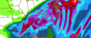
Storm total QPF (predicted liquid equivalent)
3:25 PM, January 21, 2016Cynthia Brewer Feathers /
thank you for explaining things so clearly! Stocked with beer, wine and some good books (the old fashioned kind). Hoping for a mostly snow event.
4:25 PM, January 21, 2016Ashley /
Thanks for your insight on the upcoming storm! There are so many factors affecting the forecast, it is difficult to get a good idea of what to expect. This is especially true for areas surrounding Raleigh. Could you shed some light on what you expect north of Raleigh, specifically for the Franklinton / Youngsville area?
7:48 PM, January 21, 2016jdkstaub /
I am more excited than my kids!