« Archives in February, 2015

Don’t ‘Glaze Over’ the Bitter Cold

Once in a ‘long time’ event for freezing rain at crazy low surface temps is underway.

Temps in the Triangle are either side of 20° even as a freeing rain / sleet mix falls.  This is very impressive from a meteorological weenie perspective.

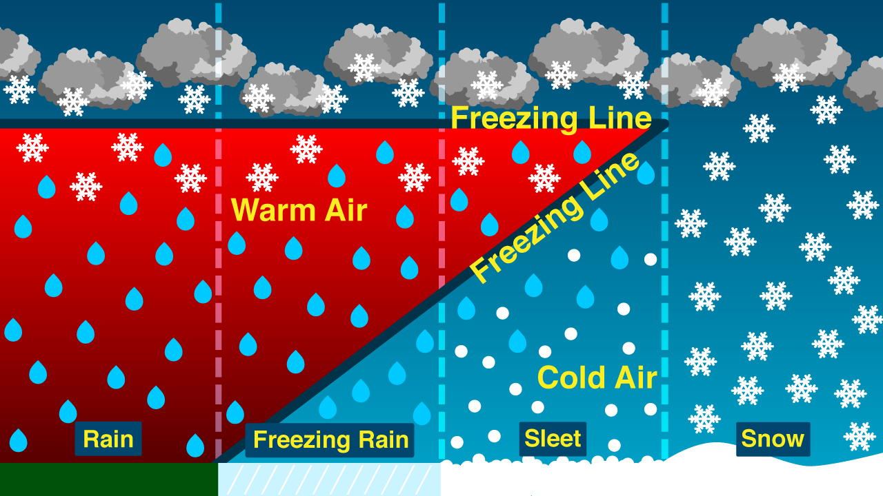
Things are going pretty much according to plan.  I expected to see a little more snow/sleet earlier to achieve a little more in the way of white accumulation this evening.  But we will still see periods of primarily sleet driven by higher precip rate cells thru the night.  Expect sleet showers and freezing rain to waffle (special lady) back and forth favoring freezing rain from Raleigh south.  Then maybe a a little sleet near daybreak as the freezing rain ends.

The better case scenario would be for more sleet rather than freezing rain, which would limit the accrual of ice on trees and power lines.  I’m actually optimistic that Raleigh may see enough sleet mixing in that we will luck out with only 1/4 to 1/3″ of glaze.  In southern Wake Co. maybe not so much with up to 1/2″ or more.

ice-storm-1

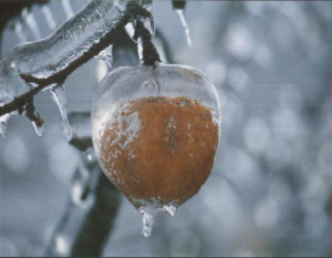
Like I said yesterday, no matter how you slice it…this will be a major event for much of NC regardless of how much white stuff is on the ground vs. the glassy stuff in the trees.  Widespread power outages will be the norm.

Final call for Raleigh is 1/2″ of snow/sleet and 1/3″ of ice glaze.

Behind the wintry precip comes the coldest air in 20 years.  As the arctic front arrives on Wed, expect to see some snow showers.  Then Wed night lows at 3-7.  Thursday highs will not get out of the teens…under a decent amount of sun.  Then the fun begins as the watch for a below 0 low begins…will we make it?!  perhaps.

Still watching a couple of systems over the weekend and early next week for more winter weather fun!


What Time Is It? 4:30

Anybody get this music reference?

nclock-04-30_33864_lg

Best guess for the Triangle is that an initial band of light snow begins to spread from west to east between 4 to 5.  The latest short range modeling indicates that this initial band will be light and spotty as the very dry atmosphere in place slowly moistens up.

Don’t be disappointed that when it begins, that the precip does not steadily come down until more like 8.

I’ll refine the forecast later this afternoon…probably something like 1-2″ of snow/sleet and 1/4 to 1/3″ of ice for Raleigh.

more later…


Sooner or Later

The quicker onset idea has troubled me today.  And the 0Z models hint that maybe we won’t see the mid afternoon start that I’ve seen touted in some media outlets today.  While a couple of flurries are possible early, it seems the more prudent timetable for substantive snow/sleet in the Triangle is more like 5-7pm.

Further, the more prudent approach is to see how the precip shield presents on radar tomorrow AM and extrapolate from there…rather than rely on machines crunching a bunch of 0s and 1s a billion times over.

Remember the bigger story may end up being bitter cold…like 15-year cold into Thursday.

mas mañana!


You Want It? You Got It!

If you want snow or sleet or freezing rain, you’re gonna be happy.  Heck, if you want a low of zero, you’ve got a chance for that too!

Following along the thinking of last evening’s post, the next 7-10 days should be the heart of our winter…certainly from a cold standpoint.

First things first…tomorrow night’s storm.  As previously noted, the timetable has been edged earlier over the past couple days such that we should see light snow breakout in the Triangle tomorrow afternoon sometime between 4 and 6pm. Expect the event to be winding down early Tuesday morning from west to east.

As goes climatology, so goes the setup in precip type corridors for this storm.  That is, north and west toward Greensboro and the Va border will feature the greatest percentage of snow, transitioning through sleet and freezing rain as you go south and east.  Everybody wants to know what will end up in their backyard, of course.  Here’s what I’m going to tell you.  It won’t really matter that much.  Most of NC will end up seeing a major impact event.  And it doesn’t matter that much if you have 4″ and ice on top vs if you have 1″ of snow plus an inch of sleet plus .25″ of ice.  It’s all a mess.  And yes, I understand that all snow is much better to deal with than ice.  Of course.  I’m just saying this will be a widespread event where NC comes to a standstill for a couple days.

With the above in mind, let’s try to call it for the Triangle and then you can extrapolate geographically from there.  Precip begins as light snow late afternoon…then a snow/sleet combo thru the evening with accumulation of snow and sleet 2-3″.  By midnight there should be a freezing rain/sleet combo or even periods of just freezing rain that will add at least a tenth of ice glaze, possibly up to 1/4″.  Maybe a flurry near the end on Tuesday AM.  There could even be a lot of variance even across just Wake County…the north west part might get 3″ of snow/sleet and just a little glaze, while the south east portions end up getting 1/2″ of snow sleet and 1/4″ or more of glaze.  Hopefully, we can better define these zones later tonight and tomorrow.

Two notes: 1) Since the ground is already going to be very cold, and since the precip is arriving late afternoon when the sun is setting…the snow and sleet will sticky very quickly to everything.  Plan to be home before it begins in earnest early evening.  2) The good news about last night’s wind rage is that it took out lots of weak limbs that would be the first to go in a significant glazing situation.

Many winter events in NC come and go with their effects leaving just as quickly.  Not so this time around.  Air even colder than what we have today is set to come in behind tomorrow’s system.  All the snow and ice will be with us for the week with highs struggling to get out of the 20s on Thurs and morning lows getting awfully close to 0…yes, zero Fahrenheit.

Finally, just something to keep an eye on…there are indications in the medium to long range that while the bitter cold relaxes at the end of this week…there may be a couple more opportunities for winter weather next weekend and the following week.


A Winter’s Worth of Winter Weather in One Week

The average annual snowfall for RDU is about 7″.  We’ve obviously had no snow so far.  The days of snow drought have strung together, and last week I began to hear the bemoaning “It’s not gonna snow this year. Is it?”  The answer to that is…no.  In fact, the next 10 or so days could be the nastiest, most winter-like of the year.

We had the teaser shot of cold air arrive yesterday.  But later tonight, you’ll know the cold means business as the wind picks up even more with gust approaching 50 mph as temps plummet into the teens.  This will set the stage for Sunday when temps won’t climb out of the 20s despite abundant sun.

Then things get tricky to figure out.

The early/mid week system has been well advertised as complicated with lower than normal forecast confidence.  What makes it complicated is a 1-2 punch scenario with weak surface low riding out of the lower Miss Valley that ends up being usurped as it reaches the GA/SC coast by a developing coastal storm.

Lightest precip scenario…The southern storm tracks well to our south with a light inch or two of snow for us on it’s northern periphery.  Then the coastal storm form far enough offshore and with a sufficiently northeasterly track to limit further precip.

Heaviest precip scenario…The southern storm again tracks well to our south with that initial light inch or two or perhaps three of snow.  As it transfers energy to the developing coastal storm, precip blossoms across the eastern 2/3 of NC as this new storm center takes over and hugs the coast.  However, this solution would pull in warmer air above the surface for much of the eastern 1/3 of NC and there would be a broad transition of snow west to sleet to freezing rain to rain at the coast.  Accumulations of ice and snow would be heavy with several inches of snow west.  Then snow/ lots of sleet/ little freezing rain ending as snow.  Then little snow/little sleet/lots of freezing rain ending as snow.  You get the idea?

Perhaps the most likely scenario at this point…A combination of the above.  Probably what happens is that we get that inch or two later Monday evening as the coastal storm begins to develop.  But it doesn’t really hug the coast, it’s close enough to throw moisture back, but not a ton.  So you get heavier precip totals as you approach the coast.  But of course the coldest air is west.  So there will be the favored zone that maximizes available cold with precip…probably somewhere from the Triangle to I-95.

Should be fun to see it evolve.  At this point expect a significant event that will shut down NC for at least Tues.

Then behind the storm another shot of cold air comes in, and with snow on the ground temperature will really bottom out.  Depending on sky cover, single digits to zero could be in the works.

Finally, what’s behind that?  Another Fri/Sat storm?


More Waffling Than…

…the “Special Lady at the Waffle House”

hqdefault

Yesterday we talked about a more suppressed storm track and what that would mean for us.  Some of the runs have shown some reeeeeally suppressed solutions (6Z GFS had no precip in NC) and even the operational 12Z Euro is pretty far south, with NC on the northern edge of the precip shield until the low rounds the bend at the coast heading north.  In this scenario, east of I-95 gets the worst of it.

But this far out, as much fun as it is to look at each model run come in, we really need to paint with a broad brush of generalities.  What we’re likely to see are track solutions jumping back and forth before settling down over the weekend.  At this point, I am expecting a significant winter episode for much of NC early Tues into Wed.  We can talk amounts and ptype over the weekend.

One more thing to address…the well-advertised cold we have now and even colder shot coming Sat night will set the stage for any frozen precipitation to quickly cause problems.  Many times with NC winter events, some portion of the initial snow or sleet is lost from accumulating because of warm antecedent ground conditions.  This will not be the case this go round.  (Remember when .3″ of snow caused 10hrs of gridlock back in 2005?!  That was primarily because the roads were very cold to start with.)

Stay tuned.  It should be fun to see how this evolves.

I Love It When a Plan Comes Together


Ok, so maybe a plan hasn’t come together, but at least we’re beginning to see convergence in model solutions.

I’ve said for days that a winter weather event mid next week fits the pattern, and now the latest 12Z suite of model guidance speaks with a voice of unanimity of a more suppressed storm track and slightly quicker timing than previously depicted.  These two items work in favor of a significant wintry mess.  The suppressed storm track means we would be squarely on the northern side of the storm track (colder).  The moisture arriving quicker would ‘lock in’ a cold air wedge at the surface from strong evaporative cooling realized by dropping moisture into the abnormally cold, dry air initially in place.  As far as sensible weather…this would mean precip begins as snow, then changes to sleet, then freezing rain.  More snow and sleet north and west.  More sleet and freezing rain south and east.  Then rain to the south and east of the freezing rain.  That’s the plan.  Where does the transition zone lie?  If you believe today’s runs, then the Triangle would spend the majority of the event below freezing.

Freezing_New_Mid

Only problem…it’s five days away!  At this point nothing is set, but the pieces are there.  We’ll see if they align.


(next) Wednesday’s Winter Weather Waggery?

Wow…more Ws than a CSI investigation!

Long time, no blog.

Not that we should get hyped up about a potential day-8 event, but this winter that’s about the extent of what we have to cling to.  I’ve been bored with the winter weather drought and fed up with the 30-something rains…so let the snow mongering begin!

Before we get to the hypotheticals of 7-8 days out, let me affirm the significance of the cold air on the way for this weekend.  It will be impressive.  Lows in the low teens, and highs on Sunday (despite a lot of sun) in the mid 20s.

2048px-Lorenz_attractor_yb.svg

Then as the pattern relaxes a bit after that, how quickly will a southern stream disturbance arrive in NC where the cold resides?  Long range modeling has been

hinting at a confluence of the two for a couple of days.  Over the past couple of model run cycles there seems to be more agreement that a storm with a southerly track will affect the SE by mid-week.  How the low tracks is up for grabs…and as you know, you’ll want to be on the northern side of the track to receive wintry precip.

That’s enough for now.  Just be alert the possibility.

And…I’ll tease you with a new game that I’ll introduce in tomorrow’s post. 😉