« Posts under SNOW

Now, Now Kids… Let’s Play ICE

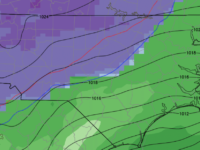
We are now entering the “short term modeling window”. To this point, we’ve been using large-scale models for general macroscale storm guidance. There is now general consensus on the evolution of the storm such that, the track of the surface low (and coastal front with its warm push intrusion) probably won’t differ by more than 20 to 50 miles. Those 20-50 miles will be crucial for those on the eastern edge battle front, which will be near Wake County.

Let’s back up to clarify… barring any crazy last minute monkey-wrenches, the outline from last night holds. In Raleigh, we should see snow begin 4-6am Sunday morning. This will be short-lived. Expect the snow to change to sleet quickly. I expect the sleet to be short-lived as well.

The snow and sleet should lay down coverage from a light coating to an inch or so. Then, the freezing rain begins. The question becomes how long does the cold air damming remain in place against the intrusion of the warm air behind the coastal front moving from SE to NW. Here’s where the short term modeling comes into play…

Up to this point, we’ve been using large scale, coarse model grid points. Now, in the short term, the grid spacing gets much tighter, and more reliable for resolving local-scale problems like… “How far west will the surface freezing line make it?” This is key to Raleigh. The longer we stay below freezing, the more crippling accrual of ice we get.

No need to guess tonight, I’ll provide more precise ideas on what that looks like in a post tomorrow. Tonight, the key takeaway is that Sunday looks to be a treacherous travel situation. Make alternate plans.

Bonus… some of the short term models suggest that we may see a period of snow Sat afternoon. Should be inconsequential, but pretty!

Ice, Ice Baby?

Lots of time before this event… Tonight, the best guess for Raleigh is for a little bit of snow — to significant sleet — to significant iceand then rain at the end of the event.

Happy New Year!

I could/should wax poetic over the couple of different scenarios on the table as to our impending winter weather event. However, the main message to convey is that a significant winter storm is likely to impact Raleigh west thru the mountains, beginning early Sunday morning (earlier from the west to east).

As disappointing as it might be for clarity, there’s no need to hypothesize as to scenarios until we get closer in the Fri PM/Sat AM timeframe. Honestly, all solutions are on the table at this point, and we’ll probably waffle back and forth over the next couple days.

Tonight’s read indicates an impactful snow to sleet to freezing rain to rain event in Raleigh. Then, along a gradient as you go west to Greensboro you’ll see an all frozen… more snow, more sleet and freezing rain.

Happy snow-dreaming!

Things Are Looking Up…

…as in, I’m looking to up expected snow totals a bit… albeit with the risk of a Charlie Brown, Lucy, football reenactment!

A consensus is forming in the numerical guidance with regard to tonight’s snow event. QPFs have trended higher, which will lead to greater cooling of the column, which will lead to higher snow totals across the northern half of NC.

We should see precipitation break out in the Triangle in the form of rain around 9pm. Then, we’ll see that typical cold, NC winter rain thru midnight. Between midnight and 1am we should see the changeover to all snow. Precipitation rates look to be moderate, so I would expect some picturesque moderate to even heavy snow. There will be a window of just 4-5 hours for the snow, and most of it should be wrapped up by dawn. If you want to see it, set those middle of the night alarms for 3am!

Expected heaviest accumulations north of a line from Greensboro to Raleigh to Wilson. Totals will range 2-4″ with perhaps some 5-6″ totals toward the Virginia border. A good target for Raleigh is around 3″. Bust potential to the downside will be just a dusting. Bust potential to the high side would be 5″.

Ground temps and particularly road temps are fairly warm, so this accumulation will be primarily in the grass, especially early. Although with the anticipated heavier snow rates, the roads could eventual succumb to the snow. However, once the snow stops and the sun comes up, any problems will quickly dissipate.

I’m still eyeing the next system for Sunday. However, we may turn out to be on the warm side of that, but it’s something to continue to monitor. And especially interests north and west should keep tabs on the latest.

Play It Again, Sam

Raleigh has escaped the storm with the best possible outcome…a beautiful 4-7″ snow and temps hovering just above freezing to avoid any damaging ice build up.

But wait, there’s more…

It looks like there will be another round of snow and sleet early tomorrow AM as another shortwave rounds the trough.  The latest trends in the modeling indicate there could be another burst of heavy precip for at least a couple hours.  Surface temps will again be hovering close to freezing, but the precipitation rates should be high enough to achieve more accumulation.  This doesn’t look to be the case for everyone in NC, but under this band should be a thumping of 1-2″ …possibly isolated cases of 3 or 4″.   Right now the Triangle looks to be included in this next round.  And this would be just in time for tomorrow’s morning commute.  More winter fun!

Tomorrow evening clearing will following and temps will drop to the mid 20’s for lows.  Refreezing will be a major issue on Tuesday morning.

Steady, Steady…

As much as everyone wants to hear the latest… the latest is that what I outlined yesterday still looks good to me tonight.

I can see concerns for bust potential above and below my current forecast.  My thoughts on Wake Co. follow, but really they are applicable to the wider region…

  • bust big?… there will be a period of heavy snow after the initial onset of precip which quickly cycles thru rain to sleet to snow.  some models say there could be as much as 6-8″ in that initial hit.  so, you’d have that and then sleet and then frz rain.
  • bust small?… fears of the warm tongue penetrating earlier and more pronounced would limit the initial accumulation of snow and changeover precip to sleet and freezing rain much more quickly.

I’m going in the middle on this and holding firm to my forecast from yesterday.  The action starts overnight with snow beginning in earnest between 2 and 3am.  I’ll nowcast early morning with an update for how that tricky transition zone looks.


Wild Ride Coming!

It’s been many, many years since NC has experienced a winter snow of this magnitude this early in December.  This storm promises to make it a December to remember.

As has been widely advertised, there are going to be heavy snows to the west, rain to the south and east and a battle zone that should line up fairly close to a line from Raleigh to Charlotte where the forecast is super complicated and the weather super messy. I can hear the bemoaning of the infamous “line” as I type.  There are some interesting numerical modeling disagreements ongoing behind the scenes that hopefully will be resolved soon, but in the larger picture here are a couple of key points:

  • There will be a lot of moisture available for this system.  Liquid equivalents will run about 2″ for most along and south of the Triangle and Triad with amounts tapering to an inch along the Virginia border.
  • Heavy snows of 12 to 20″ will be common in places like Greensboro, Hickory, Boone, Asheville where most of the moisture comes in the form of snow with little mixing.
  • The zone to the south and east, in places like Burlington, Chapel Hill, Salisbury and Concord, should probably expected half snow, half sleet and a little freezing rain.
  • The next zone to the south and east has Durham and Raleigh and Charlotte.  I expect a mixed bag of it all…something like 3-6″, 1-2″ of sleet and 1/4 of freezing rain.  Remember that west and north in these zones you are more likely to skew to snow.  For instance, Durham may get 6″, Raleigh may only get 3 or 4″.
  • Remember that whatever snow you get will be compacted by any sleet falling on top of it.  So, you could measure 6″ pre-sleet and shrivel down to only 3″ afterwards.
  • IMPORTANT: The impacts of this event will be high and widespread no matter what form the frozen stuff on the ground is.  And after you get a couple inches, it’s really all the same in terms of impacts.  It just takes longer to go away with more of it there when it’s over.
  • Something to watch will be the extent of the freezing rain.  If the warm nose penetrates farther north and west and deeper than is currently thought, significant ice accrual could become a real problem.
  • Timing:  this looks to arrive from south to north overnight tomorrow.  For Raleigh, perhaps in the 1-3am timeframe.

As always, stay tuned as we monitor the latest trends and I will update as necessary.


Major Winter Storm Impending

Details need to be ironed out, but what it clear is that an early season winter storm is on tap for much of NC this weekend.

I don’t want to get into specifics this early… we have plenty of time for backyard forecasting later.  At this point, let’s say that from Wake Co. N and W this will be a high impact event with significant snow, sleet and freezing rain beginning at late night Sat into Sun and continuing thru Mon.  Especially from Greensboro west, the snow totals will be historic for this early in the season.

Of course, we still have three days to go, but as it is now… the model guidance is converging on a storm to remember.  Start making alternate plans for Sun, Mon and Tues of next week.


Early Season Major Winter Storm Coming (but where?)

A quick post to say, yes… there is the potential for a major winter storm in many parts of NC, VA and upstate SC this weekend.

Of course, all that potential doesn’t mean anything unless it’s in your back yard.  It’s waaaaay too early to say anything definite.  Be alert for the possibility of significant issues, especially north and west of Raleigh.  At this point, we can say that there is the potential for higher precip totals (liquid, frozen or refrozen).

We will monitor the evolution of this system for impacts Saturday night thru Monday. This will be a fun week of forecasting!

Bust Potential Is High

The current thinking on the weekend wintry weather is that Raleigh will be (slightly) on the warm side of the action.  Could be.  Or not.

Remember when you were a kid playing on the seesaw?  Did you ever play with the kid who was so very close to your weight that you could nearly balance each other?  Didn’t really matter how close, just that he/she had that extra little mass that tipped the seesaw in their favor.  And once tipped, it was all out.  They were on the ground; you were in the air.

And so, this weekend’s setup is a bit of a meteorological seesaw.  The atmosphere is really close to that tipping point where no wintry precip transitions to sleet with heavy wet snow to lots of heavy wet snow…all while surface temps hover just above freezing.

Right now, I’d be on alert for areas north of hwy 64.  This will be one of those situations where the numerical guidance will have a hard time exacting the boundary.  We’ll have to wait until tomorrow evening to really see how this plays out.  The safe bet is that Raleigh just gets a coating of white stuff.  The reality is that Raleigh could get a lot more.  And depending on where that tipping point falls (the gradient will be sharp), we could see a situation where the northern part of the county has significant accumulation, while the southern part is clear.

Let’s figure this out tomorrow!


Palm Sunday Snow?

First off, about the snow for tomorrow (Wednesday)…  it’s not a big deal.  Just like last week wasn’t a big deal.  I don’t generally post unless there will be a significant impact from an event, or i’m intrigued by the possibilities.  So, I’m actually posting now, because I’m intrigued by the potential for a Palm Sunday snow this weekend, and not what will come tomorrow.  It’s a good thing my church is smart and employs a meteorologist to guide them through any meteorological mayhem during the high holy days! 😉

And talk about climatologically unfavorable!  The setup for Sunday is out of the ordinary a) because it’s so late in the season, and b) because of the clipper-like nature of the low diving south of us from the northwest.  We generally don’t get appreciable snows from clipper systems, and many of them go over top of us or to our north, leaving us on the warm side of things.  This could be different.  There is some evidence to suggest that the March Madness that started last weekend with Virginia losing in the NCAA tourney may continue for us with a rare snow.

It’s a hundred years off in meteorologist-time, so a lot can and will change.  But it’s something to watch and see how it develops.